Witter Topo Map Arkansas
To zoom in, hover over the map of Witter
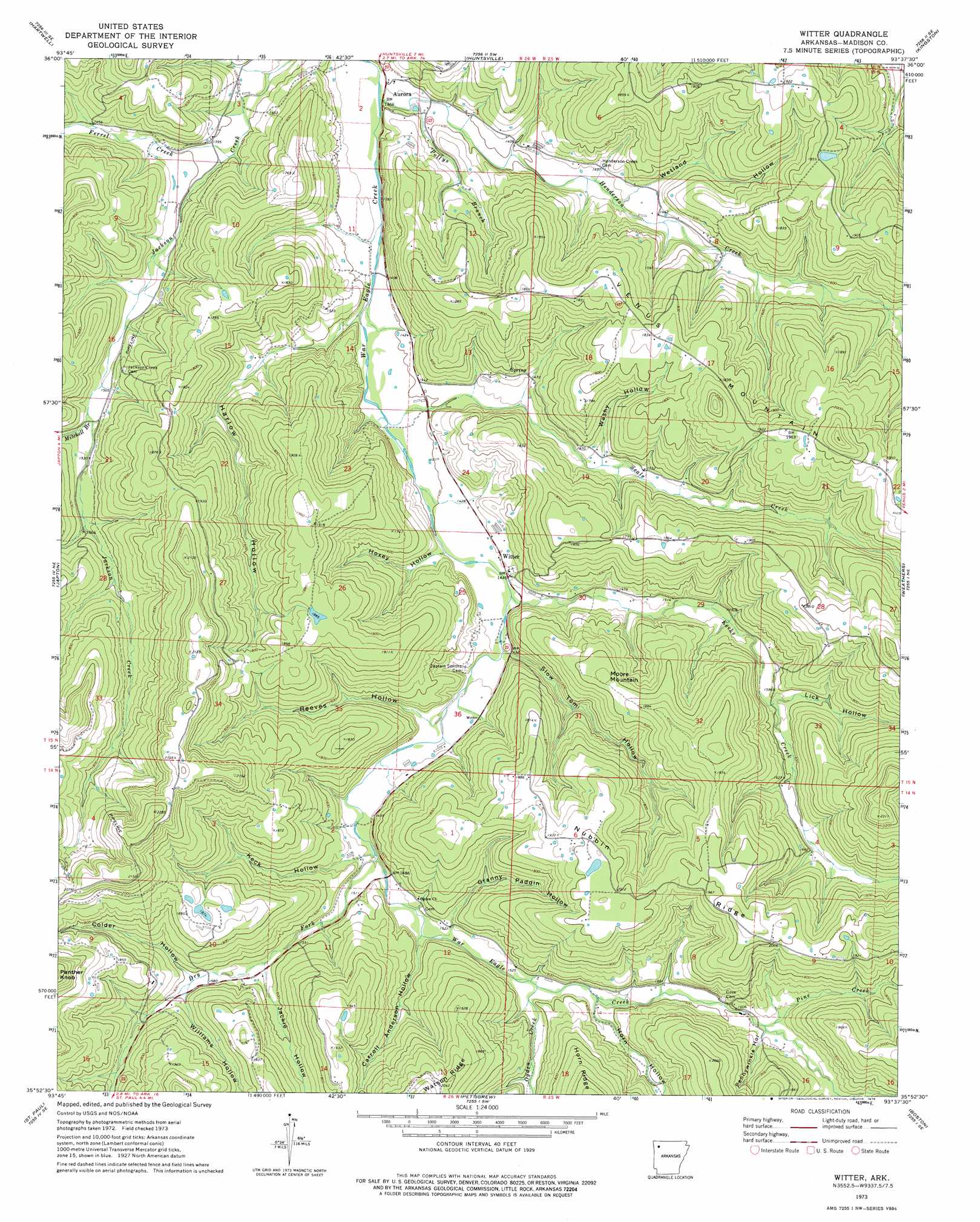
USGS Topo Quad 35093h6 - 1:24,000 scale
| Topo Map Name: | Witter |
| USGS Topo Quad ID: | 35093h6 |
| Print Size: | ca. 21 1/4" wide x 27" high |
| Southeast Coordinates: | 35.875° N latitude / 93.625° W longitude |
| Map Center Coordinates: | 35.9375° N latitude / 93.6875° W longitude |
| U.S. State: | AR |
| Filename: | o35093h6.jpg |
| Download Map JPG Image: | Witter topo map 1:24,000 scale |
| Map Type: | Topographic |
| Topo Series: | 7.5´ |
| Map Scale: | 1:24,000 |
| Source of Map Images: | United States Geological Survey (USGS) |
| Alternate Map Versions: |
Witter AR 1973, updated 1976 Download PDF Buy paper map Witter AR 2011 Download PDF Buy paper map Witter AR 2014 Download PDF Buy paper map |
1:24,000 Topo Quads surrounding Witter
Spring Valley |
Hindsville |
Forum |
Marble |
Osage |
Goshen |
Hartwell |
Huntsville |
Kingston |
Osage Sw |
Durham |
Japton |
Witter |
Weathers |
Boxley |
Delaney |
Saint Paul |
Pettigrew |
Boston |
Fallsville |
Bidville |
Cass |
Yale |
Oark |
Ozone |
> Back to 35093e1 at 1:100,000 scale
> Back to 35092a1 at 1:250,000 scale
> Back to U.S. Topo Maps home
Witter topo map: Gazetteer
Witter: Populated Places
Aurora elevation 409m 1341′Jordan (historical) elevation 610m 2001′
Venquin (historical) elevation 463m 1519′
Witter elevation 434m 1423′
Witter: Ridges
Nubbin Ridge elevation 592m 1942′Witter: Streams
Dry Fork elevation 446m 1463′Ferrel Creek elevation 419m 1374′
Henderson Creek elevation 408m 1338′
Kecks Creek elevation 429m 1407′
Mitchell Branch elevation 455m 1492′
Ogden Creek elevation 463m 1519′
Pine Creek elevation 489m 1604′
Pollys Branch elevation 411m 1348′
Seals Creek elevation 420m 1377′
Witter: Summits
Moore Mountain elevation 565m 1853′Witter: Valleys
Carroll Anderson Hollow elevation 471m 1545′Colder Hollow elevation 483m 1584′
Granny Paddin Hollow elevation 459m 1505′
Harlow Hollow elevation 417m 1368′
Horn Hollow elevation 469m 1538′
Hoxey Hollow elevation 428m 1404′
Jackie Hollow elevation 486m 1594′
Keck Hollow elevation 454m 1489′
Lick Hollow elevation 477m 1564′
Pennywinkle Hollow elevation 496m 1627′
Reeves Hollow elevation 440m 1443′
Slow Tom Hollow elevation 441m 1446′
Washy Hollow elevation 552m 1811′
Wetland Hollow elevation 439m 1440′
Williams Hollow elevation 486m 1594′
Witter digital topo map on disk
Buy this Witter topo map showing relief, roads, GPS coordinates and other geographical features, as a high-resolution digital map file on DVD: