Ione Topo Map Arkansas
To zoom in, hover over the map of Ione
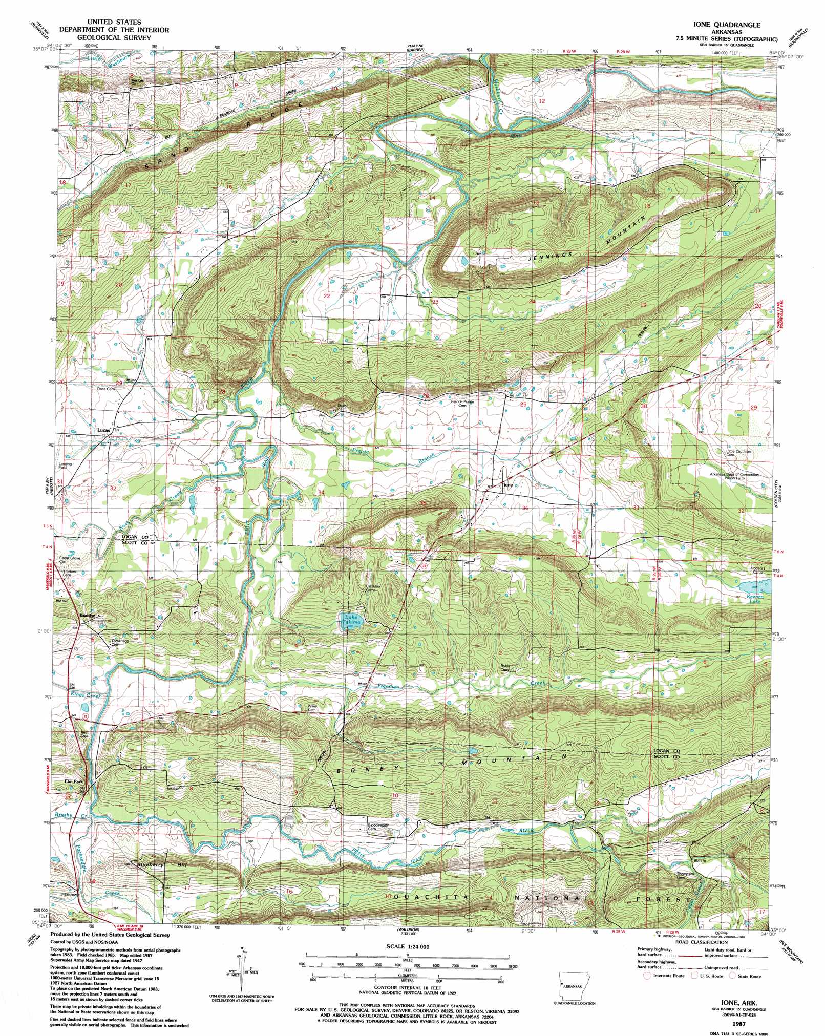
USGS Topo Quad 35094a1 - 1:24,000 scale
| Topo Map Name: | Ione |
| USGS Topo Quad ID: | 35094a1 |
| Print Size: | ca. 21 1/4" wide x 27" high |
| Southeast Coordinates: | 35° N latitude / 94° W longitude |
| Map Center Coordinates: | 35.0625° N latitude / 94.0625° W longitude |
| U.S. State: | AR |
| Filename: | o35094a1.jpg |
| Download Map JPG Image: | Ione topo map 1:24,000 scale |
| Map Type: | Topographic |
| Topo Series: | 7.5´ |
| Map Scale: | 1:24,000 |
| Source of Map Images: | United States Geological Survey (USGS) |
| Alternate Map Versions: |
Ione AR 1947, updated 1976 Download PDF Buy paper map Ione AR 1951 Download PDF Buy paper map Ione AR 1987, updated 1988 Download PDF Buy paper map Ione AR 2011 Download PDF Buy paper map Ione AR 2014 Download PDF Buy paper map |
| FStopo: | US Forest Service topo Ione is available: Download FStopo PDF Download FStopo TIF |
1:24,000 Topo Quads surrounding Ione
Barling |
Lavaca |
Charleston |
Branch |
Caulksville |
Greenwood |
Burnville |
Barber |
Booneville |
Magazine |
Huntington |
Abbott |
Ione |
Golden City |
Sugar Grove |
Cauthron |
Hon |
Waldron |
Bee Mountain |
Freedom Mountain |
Horseshoe Mountain |
Peanut Mountain |
Boles |
Parks |
Harvey |
> Back to 35094a1 at 1:100,000 scale
> Back to 35094a1 at 1:250,000 scale
> Back to U.S. Topo Maps home
Ione topo map: Gazetteer
Ione: Airports
Worth James Ranch Airport elevation 165m 541′Ione: Dams
Lake Lakima Dam elevation 180m 590′Ione: Lakes
Lake Takima elevation 179m 587′Ione: Populated Places
Boothe elevation 200m 656′Elm Park elevation 166m 544′
Ione elevation 165m 541′
Lucas elevation 159m 521′
Ione: Reservoirs
Lake Lakima elevation 180m 590′Ione: Ridges
Sand Ridge elevation 200m 656′Ione: Streams
Brushy Creek elevation 160m 524′Cedar Creek elevation 203m 666′
Freedom Creek elevation 152m 498′
Kings Creek elevation 156m 511′
Old Freedom Creek elevation 161m 528′
Packsaddle Creek elevation 160m 524′
Prairie Branch elevation 147m 482′
Prairie Creek elevation 158m 518′
Rock Creek elevation 151m 495′
Washburn Creek elevation 144m 472′
Ione: Summits
Blueberry Hill elevation 206m 675′Jennings Mountain elevation 232m 761′
Ione digital topo map on disk
Buy this Ione topo map showing relief, roads, GPS coordinates and other geographical features, as a high-resolution digital map file on DVD: