Abbott Topo Map Arkansas
To zoom in, hover over the map of Abbott
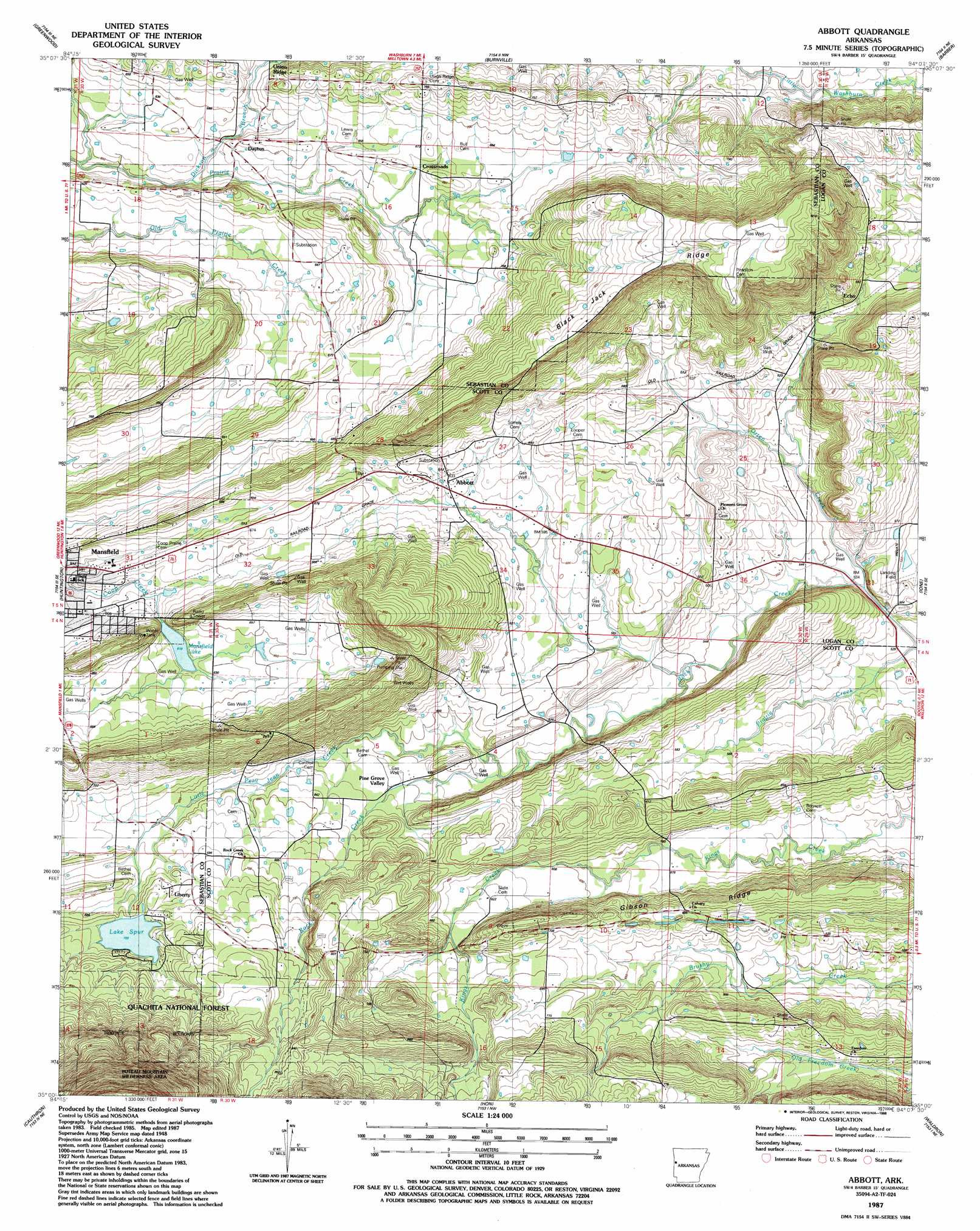
USGS Topo Quad 35094a2 - 1:24,000 scale
| Topo Map Name: | Abbott |
| USGS Topo Quad ID: | 35094a2 |
| Print Size: | ca. 21 1/4" wide x 27" high |
| Southeast Coordinates: | 35° N latitude / 94.125° W longitude |
| Map Center Coordinates: | 35.0625° N latitude / 94.1875° W longitude |
| U.S. State: | AR |
| Filename: | o35094a2.jpg |
| Download Map JPG Image: | Abbott topo map 1:24,000 scale |
| Map Type: | Topographic |
| Topo Series: | 7.5´ |
| Map Scale: | 1:24,000 |
| Source of Map Images: | United States Geological Survey (USGS) |
| Alternate Map Versions: |
Abbott AR 1948, updated 1971 Download PDF Buy paper map Abbott AR 1948, updated 1979 Download PDF Buy paper map Abbott AR 1987, updated 1988 Download PDF Buy paper map Abbott AR 2011 Download PDF Buy paper map Abbott AR 2014 Download PDF Buy paper map |
| FStopo: | US Forest Service topo Abbott is available: Download FStopo PDF Download FStopo TIF |
1:24,000 Topo Quads surrounding Abbott
South Fort Smith |
Barling |
Lavaca |
Charleston |
Branch |
Hackett |
Greenwood |
Burnville |
Barber |
Booneville |
Hartford |
Huntington |
Abbott |
Ione |
Golden City |
Bates |
Cauthron |
Hon |
Waldron |
Bee Mountain |
Loving |
Horseshoe Mountain |
Peanut Mountain |
Boles |
Parks |
> Back to 35094a1 at 1:100,000 scale
> Back to 35094a1 at 1:250,000 scale
> Back to U.S. Topo Maps home
Abbott topo map: Gazetteer
Abbott: Dams
Lake Spur Dam elevation 213m 698′Mansfield Dam elevation 193m 633′
Abbott: Lakes
Lake Spur elevation 213m 698′Abbott: Oilfields
Mansfield Gas Field elevation 194m 636′Abbott: Populated Places
Abbott elevation 190m 623′Bluff Ridge (historical) elevation 185m 606′
Crossroads elevation 209m 685′
Dayton elevation 193m 633′
Echo elevation 210m 688′
Kings Creek (historical) elevation 196m 643′
Lewis elevation 160m 524′
Liberty elevation 210m 688′
Abbott: Reservoirs
Mansfield Lake elevation 193m 633′Abbott: Ridges
Black Jack Ridge elevation 285m 935′Coop Ridge elevation 295m 967′
Gibson Ridge elevation 214m 702′
Union Ridge elevation 217m 711′
Abbott: Streams
Dickson Branch elevation 181m 593′Henry Branch elevation 182m 597′
Little Petit Jean Creek elevation 172m 564′
Orten Creek elevation 159m 521′
Abbott digital topo map on disk
Buy this Abbott topo map showing relief, roads, GPS coordinates and other geographical features, as a high-resolution digital map file on DVD: