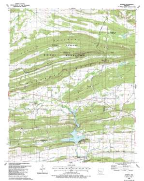
Barber Topo Map Arkansas
To zoom in, hover over the map of Barber
USGS Topo Quad 35094b1 - 1:24,000 scale
| Topo Map Name: | Barber |
| USGS Topo Quad ID: | 35094b1 |
| Print Size: | ca. 21 1/4" wide x 27" high |
| Southeast Coordinates: | 35.125° N latitude / 94° W longitude |
| Map Center Coordinates: | 35.1875° N latitude / 94.0625° W longitude |
| U.S. State: | AR |
| Filename: | o35094b1.jpg |
| Download Map JPG Image: | Barber topo map 1:24,000 scale |
| Map Type: | Topographic |
| Topo Series: | 7.5´ |
| Map Scale: | 1:24,000 |
| Source of Map Images: | United States Geological Survey (USGS) |
| Alternate Map Versions: |
Barber AR 1947, updated 1973 Download PDF Buy paper map Barber AR 1947, updated 1978 Download PDF Buy paper map Barber AR 1951 Download PDF Buy paper map Barber AR 1987, updated 1988 Download PDF Buy paper map Barber AR 1997, updated 1999 Download PDF Buy paper map Barber AR 2011 Download PDF Buy paper map Barber AR 2014 Download PDF Buy paper map |
1:24,000 Topo Quads surrounding Barber
> Back to 35094a1 at 1:100,000 scale
> Back to 35094a1 at 1:250,000 scale
> Back to U.S. Topo Maps home
Barber topo map: Gazetteer
Barber: Dams
Sixmile Creek Watershed Site 12 Dam elevation 155m 508′Upper Petit Jean Site Number Nine Dam elevation 160m 524′
Barber: Gaps
Backbone Narrows elevation 220m 721′Bradshaw Narrows elevation 212m 695′
Rattlesnake Narrows elevation 283m 928′
Barber: Oilfields
Booneville Gas Field elevation 184m 603′Barber: Populated Places
Barber elevation 167m 547′Glendale elevation 182m 597′
Leon (historical) elevation 155m 508′
Washburn elevation 182m 597′
Barber: Post Offices
Barber Post Office (historical) elevation 174m 570′Barber: Reservoirs
Booneville Lake elevation 163m 534′Sixmile Creek Watershed Site 12 Reservoir elevation 155m 508′
Upper Petit Jean Site Number Nine Reservoir elevation 160m 524′
Barber: Ridges
Barber Ridge elevation 149m 488′Blythe Ridge elevation 213m 698′
Green Ridge elevation 208m 682′
Mebane Ridge elevation 218m 715′
Pleasant Ridge elevation 239m 784′
Barber: Streams
Gin Creek elevation 161m 528′Little Washburn Creek elevation 148m 485′
Molly Gap Creek elevation 166m 544′
Pigeon Creek elevation 159m 521′
Polecat Branch elevation 147m 482′
Barber: Summits
Pine Hill elevation 207m 679′Pinnacle Mountain elevation 368m 1207′
Barber digital topo map on disk
Buy this Barber topo map showing relief, roads, GPS coordinates and other geographical features, as a high-resolution digital map file on DVD:


