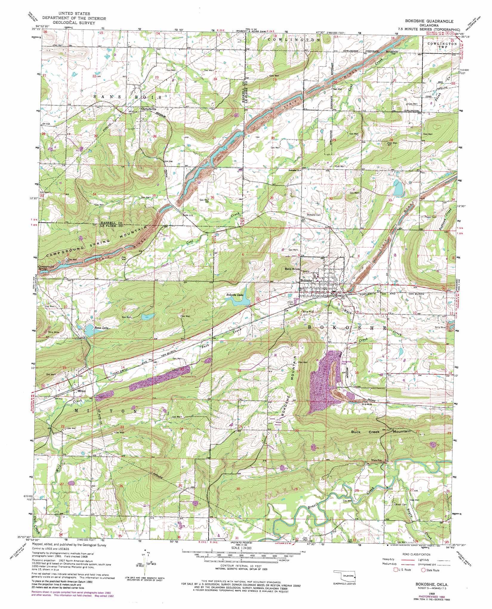
Bokoshe Topo Map Oklahoma
To zoom in, hover over the map of Bokoshe
USGS Topo Quad 35094b7 - 1:24,000 scale
| Topo Map Name: | Bokoshe |
| USGS Topo Quad ID: | 35094b7 |
| Print Size: | ca. 21 1/4" wide x 27" high |
| Southeast Coordinates: | 35.125° N latitude / 94.75° W longitude |
| Map Center Coordinates: | 35.1875° N latitude / 94.8125° W longitude |
| U.S. State: | OK |
| Filename: | o35094b7.jpg |
| Download Map JPG Image: | Bokoshe topo map 1:24,000 scale |
| Map Type: | Topographic |
| Topo Series: | 7.5´ |
| Map Scale: | 1:24,000 |
| Source of Map Images: | United States Geological Survey (USGS) |
| Alternate Map Versions: |
Bokoshe OK 1968, updated 1969 Download PDF Buy paper map Bokoshe OK 1968, updated 1977 Download PDF Buy paper map Bokoshe OK 1968, updated 1983 Download PDF Buy paper map Bokoshe OK 2010 Download PDF Buy paper map Bokoshe OK 2012 Download PDF Buy paper map Bokoshe OK 2016 Download PDF Buy paper map |
1:24,000 Topo Quads surrounding Bokoshe
Stigler Ne |
Vian |
Sallisaw |
Gans |
Muldrow |
Stigler East |
Keota |
Robert S Kerr Dam |
Muldrow Sw |
Fort Coffee |
Lafayette |
Mccurtain |
Bokoshe |
Panama |
Spiro |
Lequire |
Mccurtain Sw |
Potato Peaks |
Poteau West |
Poteau East |
Red Oak |
Leflore |
Summerfield |
Wister |
Heavener |
> Back to 35094a1 at 1:100,000 scale
> Back to 35094a1 at 1:250,000 scale
> Back to U.S. Topo Maps home
Bokoshe topo map: Gazetteer
Bokoshe: Dams
Bokoshe Lake Dam elevation 165m 541′Oknoname 079001 Dam elevation 217m 711′
Reese Lake Dam elevation 180m 590′
Sienickie Lake Dam elevation 165m 541′
Bokoshe: Populated Places
Bokoshe elevation 157m 515′Cartersville elevation 181m 593′
Milton elevation 168m 551′
Bokoshe: Reservoirs
Bokoshe Lake elevation 165m 541′Bokoshe Lake elevation 167m 547′
Oknoname 079001 Reservoir elevation 217m 711′
Reese Lake elevation 181m 593′
Sienickie Lake elevation 165m 541′
Bokoshe: Ridges
Nubbin Ridge elevation 200m 656′Bokoshe: Streams
Doe Creek elevation 143m 469′Mack Watson Creek elevation 134m 439′
Bokoshe: Summits
Bald Knob elevation 219m 718′Bokoshe Mountain elevation 278m 912′
Buck Creek Mountain elevation 235m 770′
Bokoshe digital topo map on disk
Buy this Bokoshe topo map showing relief, roads, GPS coordinates and other geographical features, as a high-resolution digital map file on DVD: