Fort Smith Topo Map Arkansas
To zoom in, hover over the map of Fort Smith
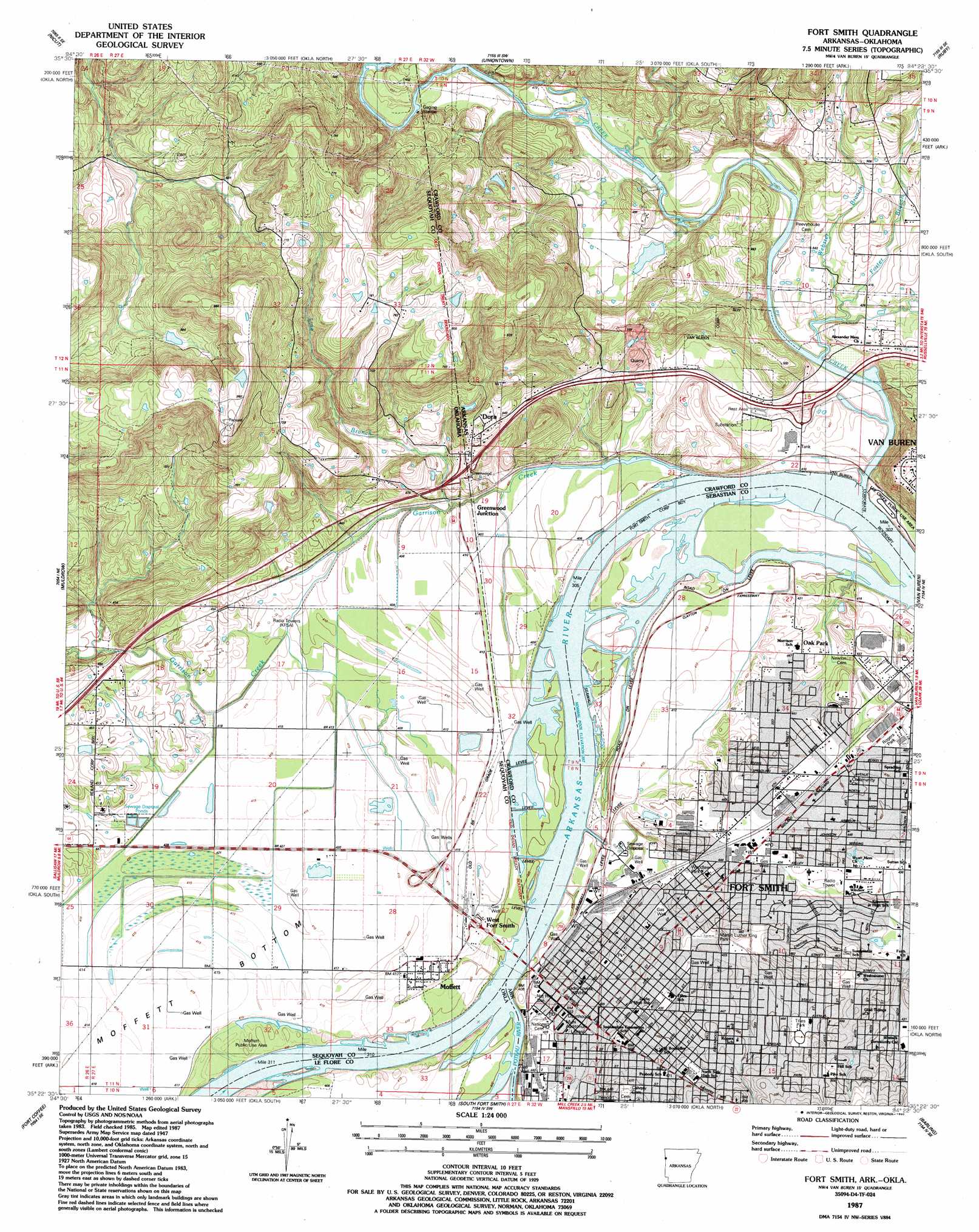
USGS Topo Quad 35094d4 - 1:24,000 scale
| Topo Map Name: | Fort Smith |
| USGS Topo Quad ID: | 35094d4 |
| Print Size: | ca. 21 1/4" wide x 27" high |
| Southeast Coordinates: | 35.375° N latitude / 94.375° W longitude |
| Map Center Coordinates: | 35.4375° N latitude / 94.4375° W longitude |
| U.S. States: | AR, OK |
| Filename: | o35094d4.jpg |
| Download Map JPG Image: | Fort Smith topo map 1:24,000 scale |
| Map Type: | Topographic |
| Topo Series: | 7.5´ |
| Map Scale: | 1:24,000 |
| Source of Map Images: | United States Geological Survey (USGS) |
| Alternate Map Versions: |
Fort Smith AR 1947, updated 1966 Download PDF Buy paper map Fort Smith AR 1947, updated 1973 Download PDF Buy paper map Fort Smith AR 1947, updated 1974 Download PDF Buy paper map Fort Smith AR 1947, updated 1978 Download PDF Buy paper map Fort Smith AR 1951 Download PDF Buy paper map Fort Smith AR 1976, updated 1978 Download PDF Buy paper map Fort Smith AR 1987, updated 1988 Download PDF Buy paper map Fort Smith AR 1987, updated 1990 Download PDF Buy paper map Fort Smith AR 1997, updated 1999 Download PDF Buy paper map Fort Smith AR 2011 Download PDF Buy paper map Fort Smith AR 2014 Download PDF Buy paper map |
1:24,000 Topo Quads surrounding Fort Smith
Greasy |
Big Round Mountain |
Natural Dam |
Rudy Ne |
Mountainburg |
Brushy |
Nicut |
Uniontown |
Rudy |
Mountainburg Sw |
Gans |
Muldrow |
Fort Smith |
Van Buren |
Alma |
Muldrow Sw |
Fort Coffee |
South Fort Smith |
Barling |
Lavaca |
Panama |
Spiro |
Hackett |
Greenwood |
Burnville |
> Back to 35094a1 at 1:100,000 scale
> Back to 35094a1 at 1:250,000 scale
> Back to U.S. Topo Maps home
Fort Smith topo map: Gazetteer
Fort Smith: Airports
Sparks Regional Medical Center Heliport elevation 137m 449′Venture Aerodrome Airpark Number 2 elevation 143m 469′
Fort Smith: Capes
Belle Point elevation 121m 396′Fort Smith: Crossings
Interchange 1 elevation 152m 498′Interchange 3 elevation 124m 406′
Fort Smith: Dams
Montgomery Lake Dam elevation 128m 419′Fort Smith: Oilfields
Greenwood Junction Gas Field elevation 248m 813′Fort Smith: Parks
Andrews Field elevation 133m 436′Belle Grove Historic District elevation 132m 433′
Fort Smith National Historic Site elevation 132m 433′
Harley Wilson Park elevation 126m 413′
Harper Stadium elevation 142m 465′
Kay Rodgers Park elevation 137m 449′
Latture Park elevation 125m 410′
Lee Creek Public Use Area elevation 124m 406′
Martin Luther King Park elevation 128m 419′
Miliking Park elevation 132m 433′
Moffett Public Use Area elevation 123m 403′
Riverfront Park elevation 128m 419′
Rogers Park elevation 137m 449′
Tilles Park elevation 134m 439′
West Garrison Avenue Historic District elevation 133m 436′
Woodlawn Park elevation 135m 442′
Fort Smith: Populated Places
Dora elevation 163m 534′Fort Smith elevation 131m 429′
Greenwood elevation 149m 488′
Greenwood Junction elevation 126m 413′
Moffett elevation 126m 413′
Oak Park elevation 132m 433′
West Fort Smith elevation 128m 419′
Fort Smith: Post Offices
Fort Smith Post Office elevation 135m 442′Fort Smith: Reservoirs
Lee Creek Reservoir elevation 122m 400′Montgomery Lake elevation 128m 419′
Fort Smith: Streams
Foster Branch elevation 114m 374′Garrison Creek elevation 120m 393′
Lee Creek elevation 119m 390′
Line Branch elevation 122m 400′
Poteau River elevation 118m 387′
Webster Branch elevation 121m 396′
Fort Smith: Trails
River Trail elevation 122m 400′Fort Smith digital topo map on disk
Buy this Fort Smith topo map showing relief, roads, GPS coordinates and other geographical features, as a high-resolution digital map file on DVD: