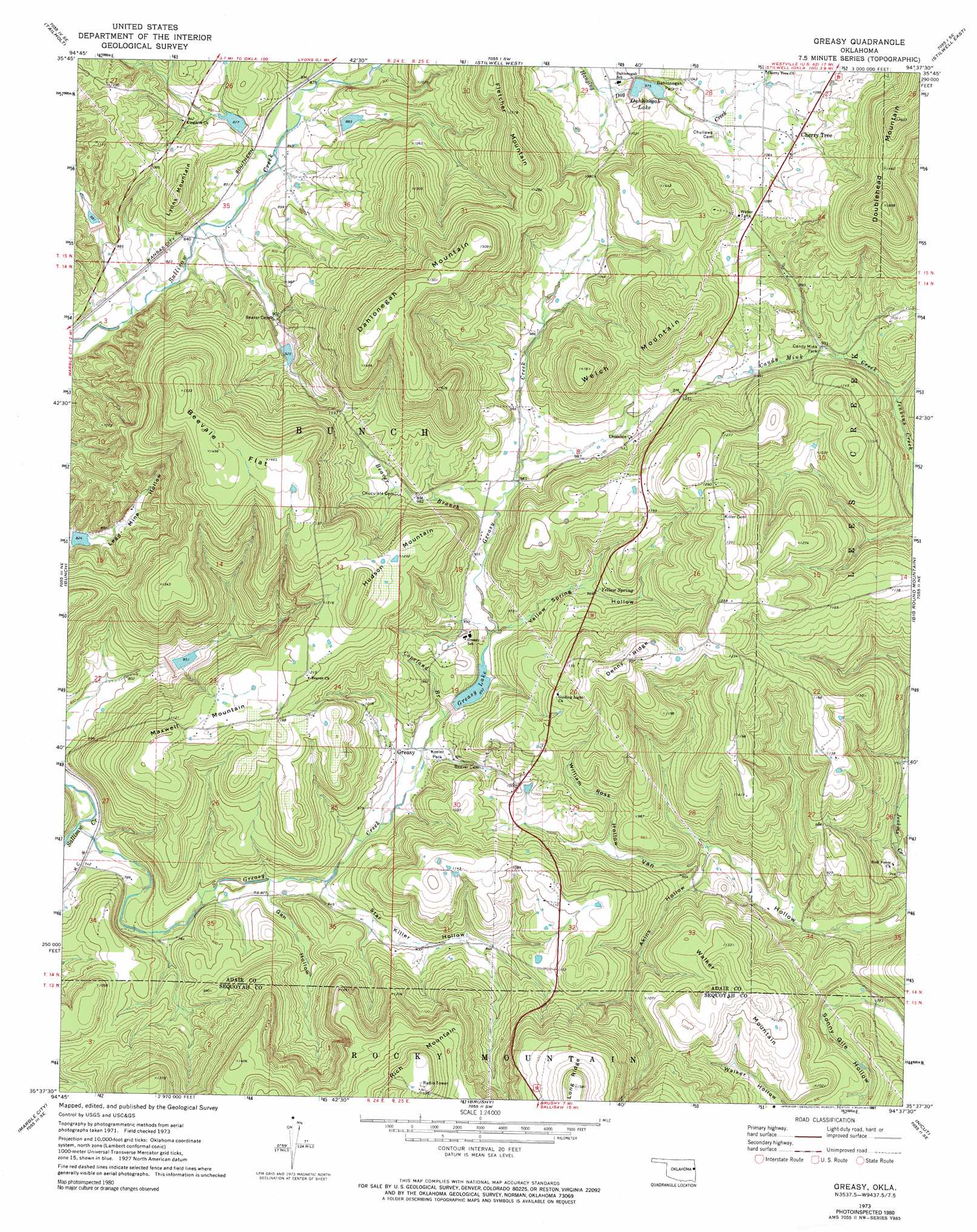
Greasy Topo Map Oklahoma
To zoom in, hover over the map of Greasy
USGS Topo Quad 35094f6 - 1:24,000 scale
| Topo Map Name: | Greasy |
| USGS Topo Quad ID: | 35094f6 |
| Print Size: | ca. 21 1/4" wide x 27" high |
| Southeast Coordinates: | 35.625° N latitude / 94.625° W longitude |
| Map Center Coordinates: | 35.6875° N latitude / 94.6875° W longitude |
| U.S. State: | OK |
| Filename: | o35094f6.jpg |
| Download Map JPG Image: | Greasy topo map 1:24,000 scale |
| Map Type: | Topographic |
| Topo Series: | 7.5´ |
| Map Scale: | 1:24,000 |
| Source of Map Images: | United States Geological Survey (USGS) |
| Alternate Map Versions: |
Greasy OK 1973, updated 1974 Download PDF Buy paper map Greasy OK 1973, updated 1991 Download PDF Buy paper map Greasy OK 2010 Download PDF Buy paper map Greasy OK 2012 Download PDF Buy paper map Greasy OK 2016 Download PDF Buy paper map |
1:24,000 Topo Quads surrounding Greasy
Tahlequah |
Proctor |
Christie |
Westville |
Lincoln |
Park Hill |
Tailholt |
Stilwell West |
Stilwell East |
Evansville |
Cookson |
Bunch |
Greasy |
Big Round Mountain |
Natural Dam |
Blackgum |
Marble City |
Brushy |
Nicut |
Uniontown |
Vian |
Sallisaw |
Gans |
Muldrow |
Fort Smith |
> Back to 35094e1 at 1:100,000 scale
> Back to 35094a1 at 1:250,000 scale
> Back to U.S. Topo Maps home
Greasy topo map: Gazetteer
Greasy: Dams
Sallisaw Creek Site 20 Dam elevation 298m 977′Sallisaw Creek Site 21 Dam elevation 272m 892′
Sallisaw Creek Site 25 Dam elevation 361m 1184′
Sallisaw Creek Site 26 Dam elevation 282m 925′
Greasy: Flats
Beevale Flat elevation 445m 1459′Greasy: Parks
Candy Mink Park elevation 281m 921′Dahlonegah Park elevation 306m 1003′
Keeler Park elevation 268m 879′
Greasy: Populated Places
Cherry Tree elevation 331m 1085′Greasy elevation 270m 885′
Greasy: Reservoirs
Dahlonegah Lake elevation 297m 974′Greasy Lake elevation 272m 892′
Sallisaw Creek Site 20 Reservoir elevation 298m 977′
Sallisaw Creek Site 21 Reservoir elevation 272m 892′
Sallisaw Creek Site 25 Reservoir elevation 361m 1184′
Sallisaw Creek Site 26 Reservoir elevation 282m 925′
Greasy: Ridges
Denny Ridge elevation 397m 1302′Greasy: Springs
Yellow Spring elevation 300m 984′Greasy: Streams
Beaver Branch elevation 286m 938′Candy Mink Creek elevation 265m 869′
Copeland Branch elevation 277m 908′
Greasy Creek elevation 219m 718′
Greasy: Summits
Dahlonegah Mountain elevation 462m 1515′Fletcher Mountain elevation 410m 1345′
Hudson Mountain elevation 410m 1345′
Lyons Mountain elevation 351m 1151′
Maxwell Mountain elevation 366m 1200′
Walker Mountain elevation 360m 1181′
Welch Mountains elevation 425m 1394′
Greasy: Valleys
Akins Hollow elevation 244m 800′Gan Hollow elevation 250m 820′
Pine Hollow elevation 257m 843′
Star Killer Hollow elevation 251m 823′
William Ross Hollow elevation 263m 862′
Yellow Spring Hollow elevation 275m 902′
Greasy digital topo map on disk
Buy this Greasy topo map showing relief, roads, GPS coordinates and other geographical features, as a high-resolution digital map file on DVD: