Bunch Topo Map Oklahoma
To zoom in, hover over the map of Bunch
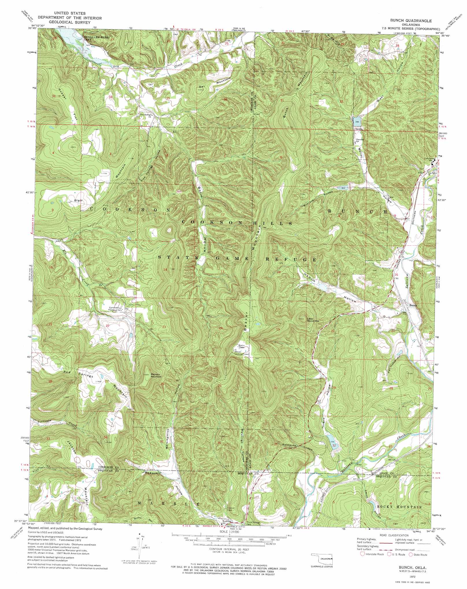
USGS Topo Quad 35094f7 - 1:24,000 scale
| Topo Map Name: | Bunch |
| USGS Topo Quad ID: | 35094f7 |
| Print Size: | ca. 21 1/4" wide x 27" high |
| Southeast Coordinates: | 35.625° N latitude / 94.75° W longitude |
| Map Center Coordinates: | 35.6875° N latitude / 94.8125° W longitude |
| U.S. State: | OK |
| Filename: | o35094f7.jpg |
| Download Map JPG Image: | Bunch topo map 1:24,000 scale |
| Map Type: | Topographic |
| Topo Series: | 7.5´ |
| Map Scale: | 1:24,000 |
| Source of Map Images: | United States Geological Survey (USGS) |
| Alternate Map Versions: |
Bunch OK 1972, updated 1974 Download PDF Buy paper map Bunch OK 2010 Download PDF Buy paper map Bunch OK 2012 Download PDF Buy paper map Bunch OK 2016 Download PDF Buy paper map |
1:24,000 Topo Quads surrounding Bunch
Thompson Corner |
Tahlequah |
Proctor |
Christie |
Westville |
Zeb |
Park Hill |
Tailholt |
Stilwell West |
Stilwell East |
Qualls |
Cookson |
Bunch |
Greasy |
Big Round Mountain |
Gore |
Blackgum |
Marble City |
Brushy |
Nicut |
Stigler Ne |
Vian |
Sallisaw |
Gans |
Muldrow |
> Back to 35094e1 at 1:100,000 scale
> Back to 35094a1 at 1:250,000 scale
> Back to U.S. Topo Maps home
Bunch topo map: Gazetteer
Bunch: Dams
Sallisaw Creek Site 12 Dam elevation 258m 846′Sallisaw Creek Site 12 Dam elevation 222m 728′
Sallisaw Creek Site 13 Dam elevation 261m 856′
Sallisaw Creek Site 14 Dam elevation 254m 833′
Sallisaw Creek Site 15 Dam elevation 278m 912′
Sallisaw Creek Site 23 Dam elevation 254m 833′
Sallisaw Creek Site 27 Dam elevation 242m 793′
Bunch: Flats
Hopper Flat elevation 357m 1171′Bunch: Parks
Cookson Hills State Game Refuge elevation 343m 1125′Bunch: Populated Places
Bunch elevation 238m 780′Dry Creek elevation 301m 987′
Bunch: Reservoirs
Sallisaw Creek Site 12 Reservoir elevation 222m 728′Sallisaw Creek Site 12 Reservoir elevation 258m 846′
Sallisaw Creek Site 13 Reservoir elevation 261m 856′
Sallisaw Creek Site 14 Reservoir elevation 254m 833′
Sallisaw Creek Site 15 Reservoir elevation 278m 912′
Sallisaw Creek Site 23 Reservoir elevation 254m 833′
Sallisaw Creek Site 27 Reservoir elevation 242m 793′
Bunch: Summits
Beaver Mountain elevation 484m 1587′Blair Mountain elevation 356m 1167′
Blaylock Mountain elevation 449m 1473′
Bunch Mountain elevation 470m 1541′
Jackson Mountain elevation 428m 1404′
Little Round Mountain elevation 445m 1459′
Owl Mountain elevation 308m 1010′
Red Springs Mountain elevation 458m 1502′
Bunch: Valleys
Bolin Hollow elevation 212m 695′Buzzard Hollow elevation 254m 833′
Fat Horse Hollow elevation 226m 741′
Goldmine Hollow elevation 205m 672′
Hamlin Hollow elevation 244m 800′
Hastings Hollow elevation 212m 695′
Lead Mine Hollow elevation 234m 767′
Malloy Hollow elevation 244m 800′
Pipe Springs Hollow elevation 222m 728′
Rider Hollow elevation 267m 875′
Smith Hollow elevation 208m 682′
Teague Hollow elevation 208m 682′
Walkingstick Hollow elevation 233m 764′
Bunch digital topo map on disk
Buy this Bunch topo map showing relief, roads, GPS coordinates and other geographical features, as a high-resolution digital map file on DVD: