Evansville Topo Map Arkansas
To zoom in, hover over the map of Evansville
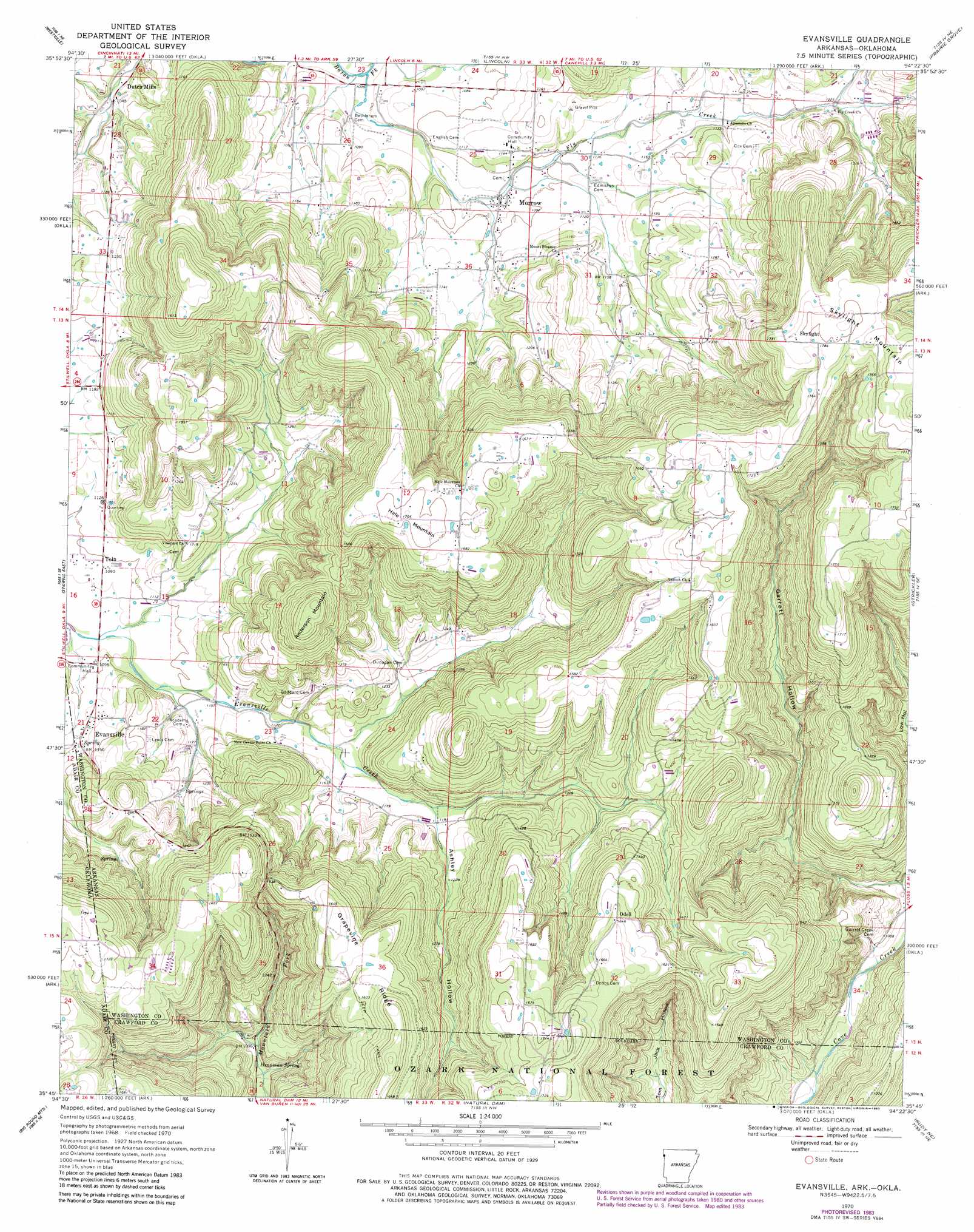
USGS Topo Quad 35094g4 - 1:24,000 scale
| Topo Map Name: | Evansville |
| USGS Topo Quad ID: | 35094g4 |
| Print Size: | ca. 21 1/4" wide x 27" high |
| Southeast Coordinates: | 35.75° N latitude / 94.375° W longitude |
| Map Center Coordinates: | 35.8125° N latitude / 94.4375° W longitude |
| U.S. States: | AR, OK |
| Filename: | o35094g4.jpg |
| Download Map JPG Image: | Evansville topo map 1:24,000 scale |
| Map Type: | Topographic |
| Topo Series: | 7.5´ |
| Map Scale: | 1:24,000 |
| Source of Map Images: | United States Geological Survey (USGS) |
| Alternate Map Versions: |
Evansville AR 1970, updated 1972 Download PDF Buy paper map Evansville AR 1970, updated 1979 Download PDF Buy paper map Evansville AR 1970, updated 1983 Download PDF Buy paper map Evansville AR 2011 Download PDF Buy paper map Evansville AR 2014 Download PDF Buy paper map |
| FStopo: | US Forest Service topo Evansville is available: Download FStopo PDF Download FStopo TIF |
1:24,000 Topo Quads surrounding Evansville
Chance |
Watts |
Rhea |
Wheeler |
Fayettville |
Christie |
Westville |
Lincoln |
Prairie Grove |
West Fork |
Stilwell West |
Stilwell East |
Evansville |
Strickler |
Winslow |
Greasy |
Big Round Mountain |
Natural Dam |
Rudy Ne |
Mountainburg |
Brushy |
Nicut |
Uniontown |
Rudy |
Mountainburg Sw |
> Back to 35094e1 at 1:100,000 scale
> Back to 35094a1 at 1:250,000 scale
> Back to U.S. Topo Maps home
Evansville topo map: Gazetteer
Evansville: Populated Places
Evansville elevation 342m 1122′Morrow elevation 328m 1076′
Odell elevation 501m 1643′
Skylight elevation 542m 1778′
Stop (historical) elevation 306m 1003′
Tolu elevation 333m 1092′
Evansville: Post Offices
Evansville Post Office elevation 347m 1138′Morrow Post Office elevation 329m 1079′
Tolu Post Office (historical) elevation 333m 1092′
Evansville: Ridges
Grapevine Ridge elevation 523m 1715′Evansville: Springs
Hennman Spring elevation 326m 1069′Evansville: Streams
Fly Creek elevation 311m 1020′Evansville: Summits
Anderson Mountain elevation 507m 1663′Hale Mountain elevation 519m 1702′
Skylight Mountain elevation 573m 1879′
Evansville: Valleys
Ashley Hollow elevation 364m 1194′Garrett Hollow elevation 294m 964′
Low Gap Hollow elevation 457m 1499′
Low Hollow elevation 317m 1040′
Evansville digital topo map on disk
Buy this Evansville topo map showing relief, roads, GPS coordinates and other geographical features, as a high-resolution digital map file on DVD: