Northeast Muskogee Topo Map Oklahoma
To zoom in, hover over the map of Northeast Muskogee
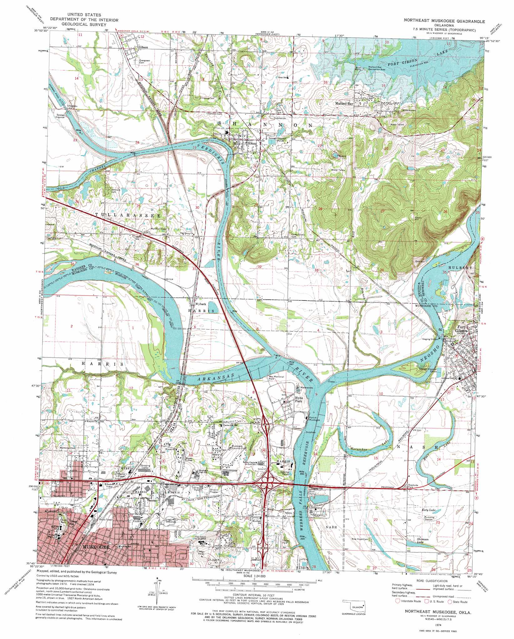
USGS Topo Quad 35095g3 - 1:24,000 scale
| Topo Map Name: | Northeast Muskogee |
| USGS Topo Quad ID: | 35095g3 |
| Print Size: | ca. 21 1/4" wide x 27" high |
| Southeast Coordinates: | 35.75° N latitude / 95.25° W longitude |
| Map Center Coordinates: | 35.8125° N latitude / 95.3125° W longitude |
| U.S. State: | OK |
| Filename: | o35095g3.jpg |
| Download Map JPG Image: | Northeast Muskogee topo map 1:24,000 scale |
| Map Type: | Topographic |
| Topo Series: | 7.5´ |
| Map Scale: | 1:24,000 |
| Source of Map Images: | United States Geological Survey (USGS) |
| Alternate Map Versions: |
Wagoner SE OK 1972, updated 1974 Download PDF Buy paper map Northeast Muskogee OK 1974, updated 1978 Download PDF Buy paper map Northeast Muskogee OK 2010 Download PDF Buy paper map Northeast Muskogee OK 2012 Download PDF Buy paper map Northeast Muskogee OK 2016 Download PDF Buy paper map |
1:24,000 Topo Quads surrounding Northeast Muskogee
Catoosa Se |
Neodesha |
Rocky Point |
Cedar Crest |
Peggs |
Red Bird |
Wagoner West |
Wagoner East |
Hulbert |
Thompson Corner |
Taft |
Northwest Muskogee |
Northeast Muskogee |
Fort Gibson Dam |
Zeb |
Beland |
Southwest Muskogee |
Southeast Muskogee |
Braggs |
Qualls |
Wainwright |
Oktaha |
Keefton |
Webbers Falls |
Gore |
> Back to 35095e1 at 1:100,000 scale
> Back to 35094a1 at 1:250,000 scale
> Back to U.S. Topo Maps home
Northeast Muskogee topo map: Gazetteer
Northeast Muskogee: Dams
Chouteau Lock elevation 156m 511′Chouteau Lock and Dam 17 elevation 156m 511′
Northeast Muskogee: Falls
Lower Verdigris Falls (historical) elevation 149m 488′Northeast Muskogee: Lakes
Horseshoe Lake elevation 151m 495′Katy Lake elevation 155m 508′
Ross Lake elevation 151m 495′
Shimoon Lake elevation 152m 498′
Northeast Muskogee: Parks
Civitan Park elevation 197m 646′Elliott Park elevation 192m 629′
Fort Gibson Stockade elevation 162m 531′
Mallard Bay Recreation Area elevation 170m 557′
War Memorial Park elevation 157m 515′
Northeast Muskogee: Populated Places
Bacone elevation 176m 577′Fort Gibson elevation 172m 564′
Gibson elevation 164m 538′
Hyde Park elevation 159m 521′
Mallard Bay elevation 185m 606′
Okay elevation 166m 544′
Wybark elevation 157m 515′
Northeast Muskogee: Reservoirs
Chouteau Lock and Dam 17 elevation 156m 511′Northeast Muskogee: Streams
Clinging Creek elevation 156m 511′Correll Branch elevation 155m 508′
Dry Branch elevation 150m 492′
Neosho River elevation 149m 488′
Old Channel Verdigris River elevation 150m 492′
Verdigris River elevation 149m 488′
Northeast Muskogee: Summits
Tower Hill elevation 201m 659′Northeast Muskogee digital topo map on disk
Buy this Northeast Muskogee topo map showing relief, roads, GPS coordinates and other geographical features, as a high-resolution digital map file on DVD: