Shawnee Ne Topo Map Oklahoma
To zoom in, hover over the map of Shawnee Ne
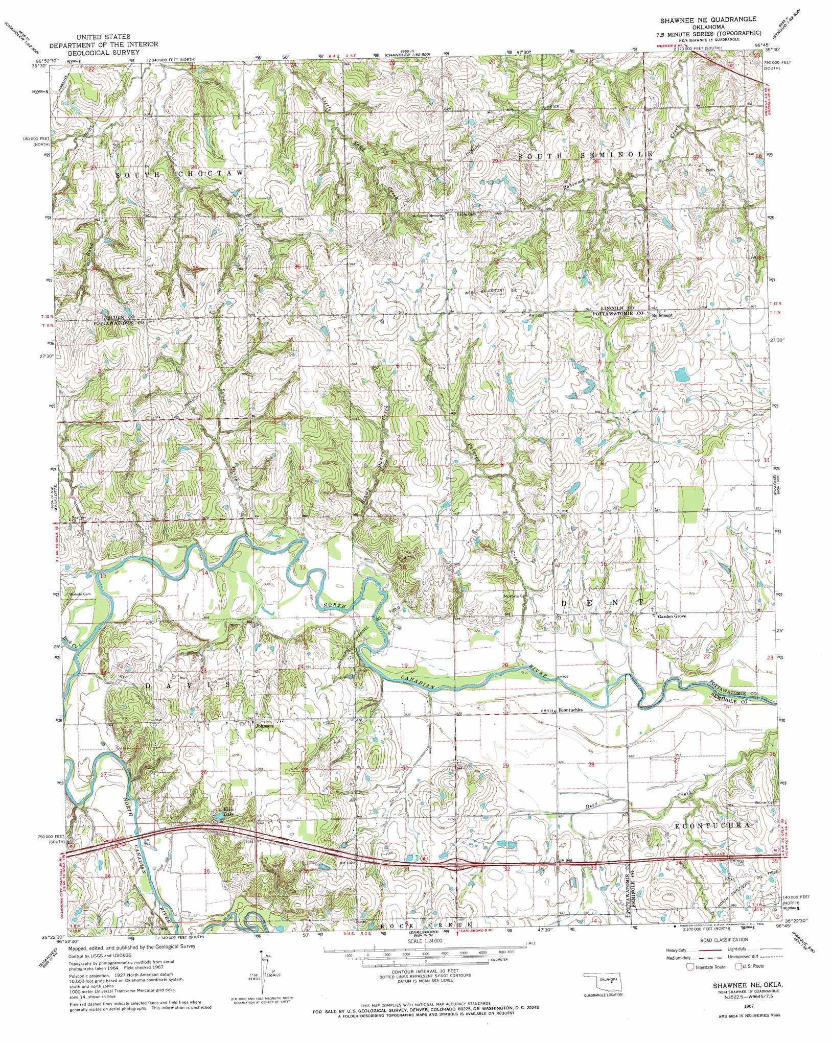
USGS Topo Quad 35096d7 - 1:24,000 scale
| Topo Map Name: | Shawnee Ne |
| USGS Topo Quad ID: | 35096d7 |
| Print Size: | ca. 21 1/4" wide x 27" high |
| Southeast Coordinates: | 35.375° N latitude / 96.75° W longitude |
| Map Center Coordinates: | 35.4375° N latitude / 96.8125° W longitude |
| U.S. State: | OK |
| Filename: | o35096d7.jpg |
| Download Map JPG Image: | Shawnee Ne topo map 1:24,000 scale |
| Map Type: | Topographic |
| Topo Series: | 7.5´ |
| Map Scale: | 1:24,000 |
| Source of Map Images: | United States Geological Survey (USGS) |
| Alternate Map Versions: |
Shawnee NE OK 1967, updated 1968 Download PDF Buy paper map Shawnee NE OK 2010 Download PDF Buy paper map Shawnee NE OK 2012 Download PDF Buy paper map Shawnee NE OK 2016 Download PDF Buy paper map |
1:24,000 Topo Quads surrounding Shawnee Ne
Wellston |
Chandler |
Davenport |
Stroud South |
Ritts Junction |
Luther Se |
Meeker |
Sparks |
Arlington |
Paden |
Mcloud |
Aydelotte |
Shawnee Ne |
Prague |
Prague Ne |
Shawnee Reservoir |
Shawnee |
Earlsboro |
Prague Sw |
Prague Se |
Macomb |
Brooksville |
Maud |
Seminole |
Wewoka West |
> Back to 35096a1 at 1:100,000 scale
> Back to 35096a1 at 1:250,000 scale
> Back to U.S. Topo Maps home
Shawnee Ne topo map: Gazetteer
Shawnee Ne: Dams
Ellis Lake Dam elevation 306m 1003′Oknoname 12517 Dam elevation 301m 987′
Oknoname 12519 Dam elevation 297m 974′
Oknoname 12520 Dam elevation 305m 1000′
Quapaw Creek Site 10 Dam elevation 277m 908′
Quapaw Creek Site 11 Dam elevation 268m 879′
Quapaw Creek Site 8 Dam elevation 270m 885′
Quapaw Creek Site 9 Dam elevation 268m 879′
Shawnee Ne: Oilfields
Northeast Shawnee Oil Field elevation 281m 921′West Bellemont Oil Field elevation 327m 1072′
Shawnee Ne: Populated Places
Bellemont elevation 318m 1043′Econtuchka elevation 279m 915′
Garden Grove elevation 293m 961′
Johnson elevation 317m 1040′
Shawnee Ne: Reservoirs
Ellis Lake elevation 308m 1010′Oknoname 12517 Reservoir elevation 301m 987′
Oknoname 12519 Reservoir elevation 297m 974′
Oknoname 12520 Reservoir elevation 305m 1000′
Quapaw Creek Site 10 Reservoir elevation 277m 908′
Quapaw Creek Site 11 Reservoir elevation 268m 879′
Quapaw Creek Site 8 Reservoir elevation 270m 885′
Quapaw Creek Site 9 Reservoir elevation 268m 879′
Shawnee Ne: Streams
Painter Creek elevation 276m 905′Rock Creek elevation 283m 928′
Squaw Creek elevation 281m 921′
Stamp Dance Creek elevation 281m 921′
Shawnee Ne digital topo map on disk
Buy this Shawnee Ne topo map showing relief, roads, GPS coordinates and other geographical features, as a high-resolution digital map file on DVD: