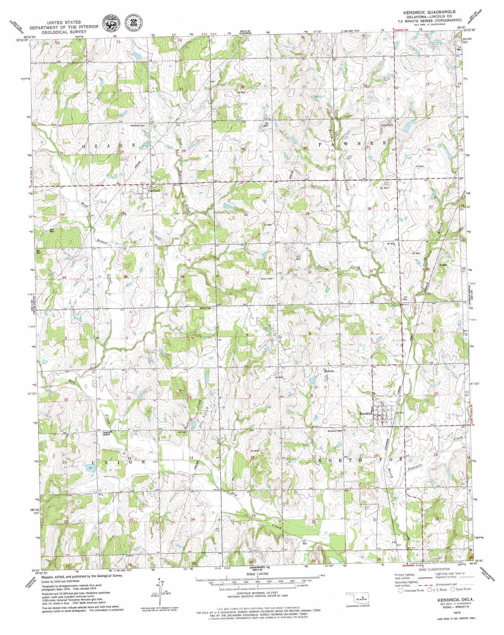
Kendrick Topo Map Oklahoma
To zoom in, hover over the map of Kendrick
USGS Topo Quad 35096g7 - 1:24,000 scale
| Topo Map Name: | Kendrick |
| USGS Topo Quad ID: | 35096g7 |
| Print Size: | ca. 21 1/4" wide x 27" high |
| Southeast Coordinates: | 35.75° N latitude / 96.75° W longitude |
| Map Center Coordinates: | 35.8125° N latitude / 96.8125° W longitude |
| U.S. State: | OK |
| Filename: | o35096g7.jpg |
| Download Map JPG Image: | Kendrick topo map 1:24,000 scale |
| Map Type: | Topographic |
| Topo Series: | 7.5´ |
| Map Scale: | 1:24,000 |
| Source of Map Images: | United States Geological Survey (USGS) |
| Alternate Map Versions: |
Kendrick OK 1975, updated 1979 Download PDF Buy paper map Kendrick OK 2010 Download PDF Buy paper map Kendrick OK 2012 Download PDF Buy paper map Kendrick OK 2016 Download PDF Buy paper map |
1:24,000 Topo Quads surrounding Kendrick
Stillwater South |
Ripley |
Twin Mounds |
Yale |
Oilton |
Perkins |
Tryon North |
Cushing |
North Village |
Drumright |
Carney |
Tryon South |
Kendrick |
Stroud North |
Depew |
Wellston |
Chandler |
Davenport |
Stroud South |
Ritts Junction |
Luther Se |
Meeker |
Sparks |
Arlington |
Paden |
> Back to 35096e1 at 1:100,000 scale
> Back to 35096a1 at 1:250,000 scale
> Back to U.S. Topo Maps home
Kendrick topo map: Gazetteer
Kendrick: Dams
Oknoname 08105 Dam elevation 268m 879′Oknoname 08114 Dam elevation 301m 987′
Oknoname 08115 Dam elevation 281m 921′
Kendrick: Populated Places
Kendrick elevation 260m 853′Parkland elevation 293m 961′
Kendrick: Reservoirs
Oknoname 08105 Reservoir elevation 268m 879′Oknoname 08114 Reservoir elevation 301m 987′
Oknoname 08115 Reservoir elevation 281m 921′
Kendrick: Streams
Beaver Creek elevation 256m 839′East Beaver Creek elevation 257m 843′
Fourmile Creek elevation 249m 816′
North Branch Ranch Creek elevation 256m 839′
Spring Creek elevation 256m 839′
Turkey Creek elevation 252m 826′
West Beaver Creek elevation 257m 843′
Kendrick digital topo map on disk
Buy this Kendrick topo map showing relief, roads, GPS coordinates and other geographical features, as a high-resolution digital map file on DVD: