Mcloud Topo Map Oklahoma
To zoom in, hover over the map of Mcloud
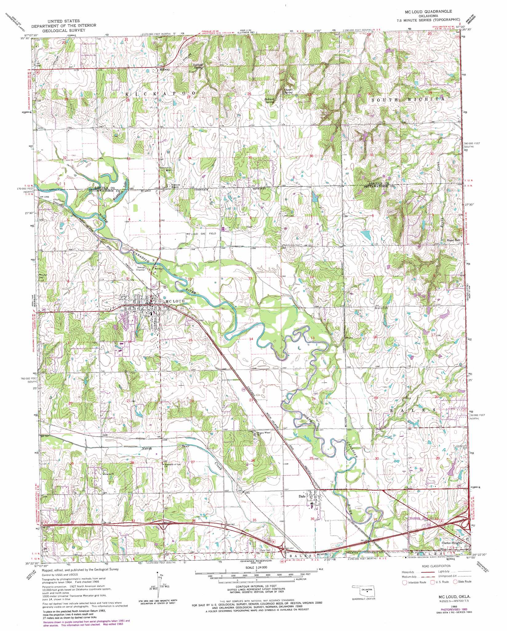
USGS Topo Quad 35097d1 - 1:24,000 scale
| Topo Map Name: | Mcloud |
| USGS Topo Quad ID: | 35097d1 |
| Print Size: | ca. 21 1/4" wide x 27" high |
| Southeast Coordinates: | 35.375° N latitude / 97° W longitude |
| Map Center Coordinates: | 35.4375° N latitude / 97.0625° W longitude |
| U.S. State: | OK |
| Filename: | o35097d1.jpg |
| Download Map JPG Image: | Mcloud topo map 1:24,000 scale |
| Map Type: | Topographic |
| Topo Series: | 7.5´ |
| Map Scale: | 1:24,000 |
| Source of Map Images: | United States Geological Survey (USGS) |
| Alternate Map Versions: |
Mc Loud OK 1966, updated 1968 Download PDF Buy paper map Mc Loud OK 1966, updated 1980 Download PDF Buy paper map Mc Loud OK 1966, updated 1983 Download PDF Buy paper map McLoud OK 2009 Download PDF Buy paper map McLoud OK 2012 Download PDF Buy paper map McLoud OK 2016 Download PDF Buy paper map |
1:24,000 Topo Quads surrounding Mcloud
Arcadia |
Luther |
Wellston |
Chandler |
Davenport |
Jones |
Horseshoe Lake |
Luther Se |
Meeker |
Sparks |
Choctaw |
Harrah |
Mcloud |
Aydelotte |
Shawnee Ne |
Franklin |
Stella |
Shawnee Reservoir |
Shawnee |
Earlsboro |
Denver |
Little Axe |
Macomb |
Brooksville |
Maud |
> Back to 35097a1 at 1:100,000 scale
> Back to 35096a1 at 1:250,000 scale
> Back to U.S. Topo Maps home
Mcloud topo map: Gazetteer
Mcloud: Airports
Flying N Ranch Airport elevation 293m 961′L D Airport elevation 336m 1102′
Mcloud: Lakes
Kishketon Lake elevation 320m 1049′Mcloud: Oilfields
McLoud Gas Field elevation 322m 1056′Mcloud: Populated Places
Clarks Heights elevation 338m 1108′Dale elevation 317m 1040′
Hazel Dell elevation 327m 1072′
McLoud elevation 333m 1092′
Midway elevation 346m 1135′
Mcloud: Springs
Bullard Spring elevation 334m 1095′Chager Spring elevation 331m 1085′
Doddehl Spring elevation 318m 1043′
Mcloud digital topo map on disk
Buy this Mcloud topo map showing relief, roads, GPS coordinates and other geographical features, as a high-resolution digital map file on DVD: