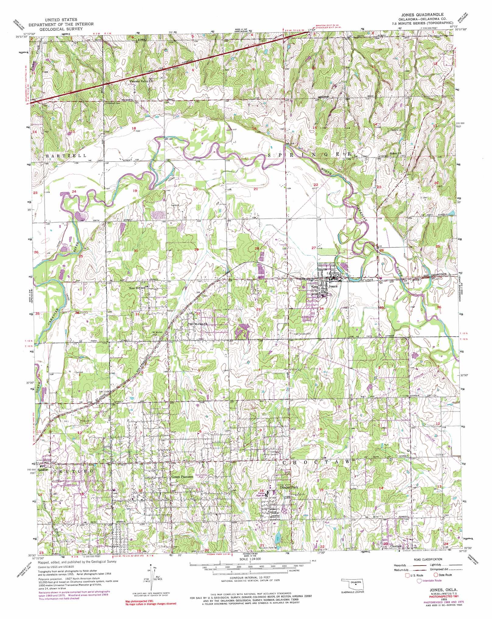
Jones Topo Map Oklahoma
To zoom in, hover over the map of Jones
USGS Topo Quad 35097e3 - 1:24,000 scale
| Topo Map Name: | Jones |
| USGS Topo Quad ID: | 35097e3 |
| Print Size: | ca. 21 1/4" wide x 27" high |
| Southeast Coordinates: | 35.5° N latitude / 97.25° W longitude |
| Map Center Coordinates: | 35.5625° N latitude / 97.3125° W longitude |
| U.S. State: | OK |
| Filename: | o35097e3.jpg |
| Download Map JPG Image: | Jones topo map 1:24,000 scale |
| Map Type: | Topographic |
| Topo Series: | 7.5´ |
| Map Scale: | 1:24,000 |
| Source of Map Images: | United States Geological Survey (USGS) |
| Alternate Map Versions: |
Jones OK 1955, updated 1957 Download PDF Buy paper map Jones OK 1955, updated 1970 Download PDF Buy paper map Jones OK 1955, updated 1976 Download PDF Buy paper map Jones OK 1955, updated 1991 Download PDF Buy paper map Jones OK 2010 Download PDF Buy paper map Jones OK 2012 Download PDF Buy paper map Jones OK 2016 Download PDF Buy paper map |
1:24,000 Topo Quads surrounding Jones
Navina |
Guthrie South |
Guthrie Se |
Meridian |
Carney |
Bethany Ne |
Edmond |
Arcadia |
Luther |
Wellston |
Britton |
Spencer |
Jones |
Horseshoe Lake |
Luther Se |
Oklahoma City |
Midwest City |
Choctaw |
Harrah |
Mcloud |
Oklahoma City Se |
Moore |
Franklin |
Stella |
Shawnee Reservoir |
> Back to 35097e1 at 1:100,000 scale
> Back to 35096a1 at 1:250,000 scale
> Back to U.S. Topo Maps home
Jones topo map: Gazetteer
Jones: Airports
Hopcus Farms Airport elevation 341m 1118′Jones: Dams
Mary Mahoney Dam elevation 352m 1154′Oknoname 7 Dam elevation 318m 1043′
Oknoname 8 Dam elevation 358m 1174′
Pate Lake Dam elevation 313m 1026′
Jones: Parks
Lewis Park elevation 375m 1230′Jones: Populated Places
Dunjee Park elevation 368m 1207′Green Pastures elevation 377m 1236′
Jones elevation 340m 1115′
Jones: Reservoirs
Mary Mahoney Reservoir elevation 352m 1154′Oknoname 7 Reservoir elevation 318m 1043′
Oknoname 8 Reservoir elevation 358m 1174′
Pate Lake elevation 313m 1026′
Jones digital topo map on disk
Buy this Jones topo map showing relief, roads, GPS coordinates and other geographical features, as a high-resolution digital map file on DVD: