Britton Topo Map Oklahoma
To zoom in, hover over the map of Britton
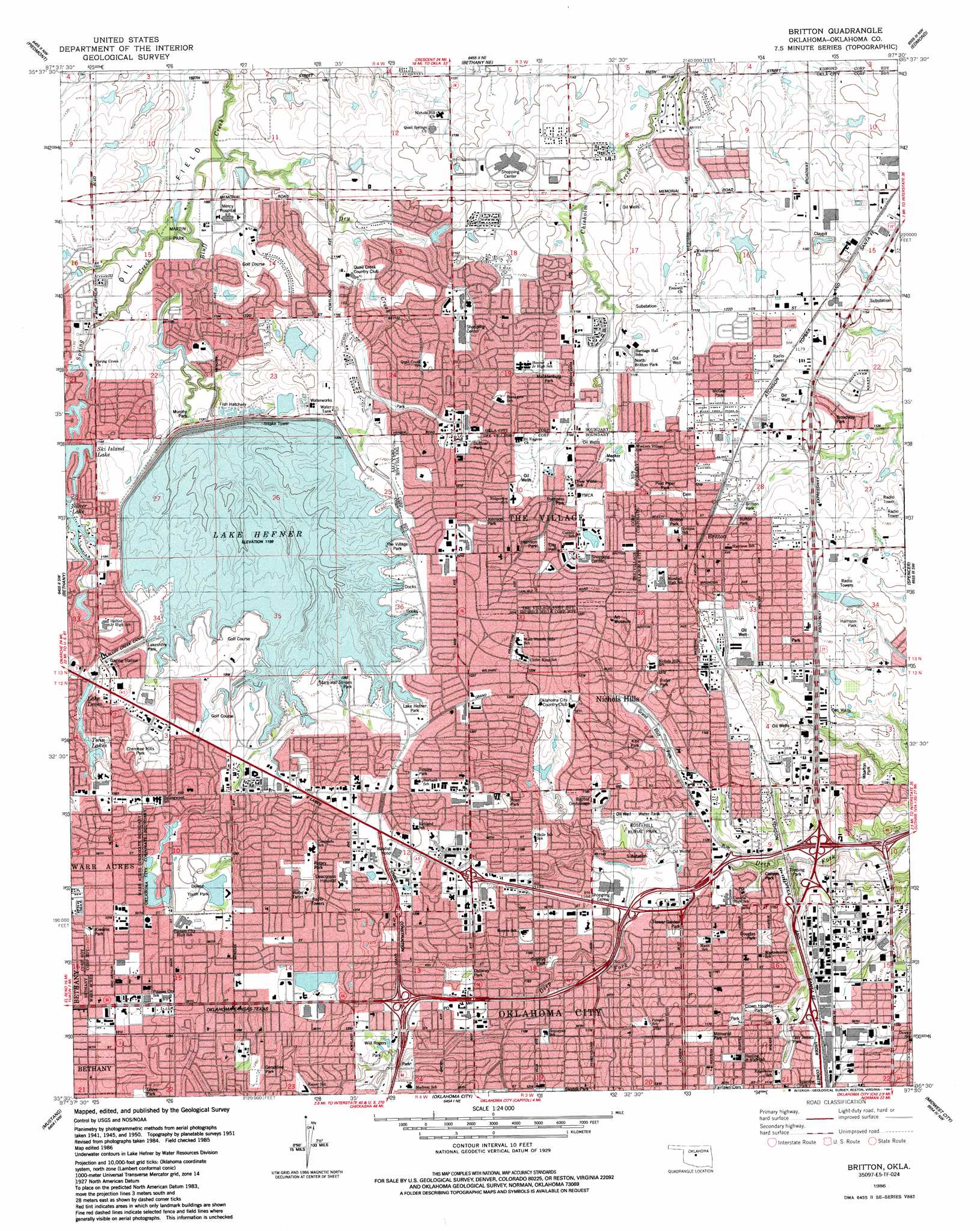
USGS Topo Quad 35097e5 - 1:24,000 scale
| Topo Map Name: | Britton |
| USGS Topo Quad ID: | 35097e5 |
| Print Size: | ca. 21 1/4" wide x 27" high |
| Southeast Coordinates: | 35.5° N latitude / 97.5° W longitude |
| Map Center Coordinates: | 35.5625° N latitude / 97.5625° W longitude |
| U.S. State: | OK |
| Filename: | o35097e5.jpg |
| Download Map JPG Image: | Britton topo map 1:24,000 scale |
| Map Type: | Topographic |
| Topo Series: | 7.5´ |
| Map Scale: | 1:24,000 |
| Source of Map Images: | United States Geological Survey (USGS) |
| Alternate Map Versions: |
Britton OK 1951, updated 1952 Download PDF Buy paper map Britton OK 1951, updated 1966 Download PDF Buy paper map Britton OK 1951, updated 1967 Download PDF Buy paper map Britton OK 1951, updated 1970 Download PDF Buy paper map Britton OK 1951, updated 1976 Download PDF Buy paper map Britton OK 1986, updated 1987 Download PDF Buy paper map Britton OK 1995, updated 1999 Download PDF Buy paper map Britton OK 2010 Download PDF Buy paper map Britton OK 2012 Download PDF Buy paper map Britton OK 2016 Download PDF Buy paper map |
1:24,000 Topo Quads surrounding Britton
Kingfisher Se |
Cashion |
Navina |
Guthrie South |
Guthrie Se |
El Reno Ne |
Piedmont |
Bethany Ne |
Edmond |
Arcadia |
Richland |
Bethany |
Britton |
Spencer |
Jones |
Minco Ne |
Mustang |
Oklahoma City |
Midwest City |
Choctaw |
Tuttle |
Oklahoma City Sw |
Oklahoma City Se |
Moore |
Franklin |
> Back to 35097e1 at 1:100,000 scale
> Back to 35096a1 at 1:250,000 scale
> Back to U.S. Topo Maps home
Britton topo map: Gazetteer
Britton: Airports
Atrium Heliport elevation 390m 1279′BMC Heliport elevation 392m 1286′
Central Park Helistop elevation 350m 1148′
Mercy Health Center Heliport elevation 342m 1122′
Britton: Dams
Belle Isle Dam elevation 348m 1141′Blue Stem Dam elevation 345m 1131′
Dry Creek Detention Dam elevation 348m 1141′
Hefner Dam elevation 350m 1148′
J W Quillian 209 Dam elevation 340m 1115′
Lansbrook Dam elevation 357m 1171′
Leven Dam elevation 365m 1197′
NW Oklahoma City Sludge Lagoon Number 1 Dam elevation 352m 1154′
Oknoname 21 Dam elevation 342m 1122′
Oknoname 24 Dam elevation 350m 1148′
Oknoname 25 Dam elevation 340m 1115′
Oknoname 26 Dam elevation 342m 1122′
Quapaw Creek Site 23 Dam elevation 363m 1190′
Roy Brown Dam elevation 330m 1082′
Sportsmans Club Dam elevation 389m 1276′
The Pines East Dam elevation 365m 1197′
Twin Lakes East Dam elevation 381m 1250′
Will Rogers Park Holding Pond Dam elevation 366m 1200′
Britton: Lakes
Lake Leven elevation 382m 1253′Shepherd Lake elevation 365m 1197′
Twin Lakes elevation 375m 1230′
Britton: Parks
Bixler Park elevation 366m 1200′Britton Park elevation 360m 1181′
Britton Park elevation 370m 1213′
Broadway Park elevation 354m 1161′
Bumpass Park elevation 363m 1190′
Burton Park elevation 366m 1200′
Canyon Park elevation 339m 1112′
Cherokee Hills Park elevation 385m 1263′
Crown Heights Park elevation 350m 1148′
Dolese Youth Park elevation 328m 1076′
Douglas Park elevation 353m 1158′
Duffner Park elevation 367m 1204′
Dulaney Park elevation 372m 1220′
Edgemere Park elevation 351m 1151′
Flower Garden Park elevation 352m 1154′
Geraldine Park elevation 391m 1282′
Grove Park elevation 398m 1305′
Guy James Park elevation 347m 1138′
Harrison Park elevation 356m 1167′
Johnson Park elevation 371m 1217′
Kite Park elevation 354m 1161′
Kiwanis Park elevation 396m 1299′
Lake Hefner Park elevation 367m 1204′
Lakeshore Park elevation 369m 1210′
Macklanburg Park elevation 361m 1184′
Martin Park elevation 329m 1079′
McGee Park elevation 362m 1187′
Meeker Park elevation 360m 1181′
Memorial Park elevation 353m 1158′
Murphy Park elevation 341m 1118′
North Britton Park elevation 357m 1171′
Pied Piper Park elevation 364m 1194′
Ross Park elevation 368m 1207′
Rotary Park elevation 392m 1286′
Smittys Park elevation 359m 1177′
Stars and Stripes Park elevation 368m 1207′
The Village Park elevation 370m 1213′
Tinsley Park elevation 376m 1233′
Topping Park elevation 341m 1118′
Wharton Park elevation 349m 1145′
Will Rogers Park elevation 364m 1194′
Britton: Populated Places
Britton elevation 372m 1220′Nichols Hills elevation 371m 1217′
The Village elevation 372m 1220′
Warr Acres elevation 399m 1309′
Britton: Reservoirs
Belle Isle Lake elevation 344m 1128′Blue Stem Lake elevation 345m 1131′
Dry Creek Dentention Reservoir elevation 348m 1141′
East Twin Lake elevation 381m 1250′
J W Quillian Reservoir elevation 340m 1115′
Lake Hefner elevation 366m 1200′
Lake Leven elevation 365m 1197′
Lansbrook Lake elevation 357m 1171′
NW Oklahoma City Sludge Lagoon elevation 352m 1154′
Oknoname 21 Reservoir elevation 342m 1122′
Oknoname 24 Reservoir elevation 350m 1148′
Oknoname 25 Lake elevation 340m 1115′
Oknoname 26 Reservoir elevation 342m 1122′
Quapaw Creek Site 23 Reservoir elevation 363m 1190′
Roy Brown Reservoir elevation 330m 1082′
Sportsmans Club Lake elevation 389m 1276′
The Pines East Lake elevation 365m 1197′
Britton: Streams
Dry Creek elevation 323m 1059′Britton digital topo map on disk
Buy this Britton topo map showing relief, roads, GPS coordinates and other geographical features, as a high-resolution digital map file on DVD: