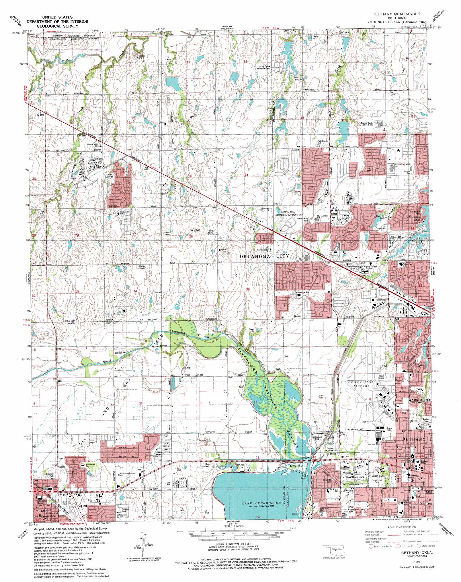
Bethany Topo Map Oklahoma
To zoom in, hover over the map of Bethany
USGS Topo Quad 35097e6 - 1:24,000 scale
| Topo Map Name: | Bethany |
| USGS Topo Quad ID: | 35097e6 |
| Print Size: | ca. 21 1/4" wide x 27" high |
| Southeast Coordinates: | 35.5° N latitude / 97.625° W longitude |
| Map Center Coordinates: | 35.5625° N latitude / 97.6875° W longitude |
| U.S. State: | OK |
| Filename: | o35097e6.jpg |
| Download Map JPG Image: | Bethany topo map 1:24,000 scale |
| Map Type: | Topographic |
| Topo Series: | 7.5´ |
| Map Scale: | 1:24,000 |
| Source of Map Images: | United States Geological Survey (USGS) |
| Alternate Map Versions: |
Bethany OK 1966, updated 1967 Download PDF Buy paper map Bethany OK 1966, updated 1976 Download PDF Buy paper map Bethany OK 1966, updated 1984 Download PDF Buy paper map Bethany OK 1986, updated 1987 Download PDF Buy paper map Bethany OK 1995, updated 1999 Download PDF Buy paper map Bethany OK 2009 Download PDF Buy paper map Bethany OK 2012 Download PDF Buy paper map Bethany OK 2016 Download PDF Buy paper map |
1:24,000 Topo Quads surrounding Bethany
Kingfisher |
Kingfisher Se |
Cashion |
Navina |
Guthrie South |
Okarche |
El Reno Ne |
Piedmont |
Bethany Ne |
Edmond |
El Reno |
Richland |
Bethany |
Britton |
Spencer |
Union City |
Minco Ne |
Mustang |
Oklahoma City |
Midwest City |
Minco |
Tuttle |
Oklahoma City Sw |
Oklahoma City Se |
Moore |
> Back to 35097e1 at 1:100,000 scale
> Back to 35096a1 at 1:250,000 scale
> Back to U.S. Topo Maps home
Bethany topo map: Gazetteer
Bethany: Airports
Sundance Airpark elevation 358m 1174′Wiley Post Airport elevation 390m 1279′
Bethany: Basins
Sedimentation Basin elevation 347m 1138′Bethany: Canals
Bluff Creek Canal elevation 378m 1240′Bethany: Dams
Cottonwood Creek Site 33 Dam elevation 347m 1138′Eagle Dam elevation 359m 1177′
Knight Dam elevation 372m 1220′
Oknoname 10 Dam elevation 341m 1118′
Oknoname 11 Dam elevation 335m 1099′
Oknoname 12 Dam elevation 349m 1145′
Oknoname 13 Dam elevation 349m 1145′
Oknoname 14 Dam elevation 354m 1161′
Regal Dam elevation 356m 1167′
Saint Francis West Dam elevation 369m 1210′
Silver Dam elevation 347m 1138′
Ski Island Dam elevation 345m 1131′
The Pines West Dam elevation 371m 1217′
Twin Lakes West Dam elevation 371m 1217′
Willow Dam elevation 357m 1171′
Woodlake Apartments Dam elevation 377m 1236′
Bethany: Parks
Bledsoe Park elevation 386m 1266′Eldon Lyon Park elevation 392m 1286′
Harvest Hills Park elevation 370m 1213′
McMillan Park elevation 381m 1250′
Riverside Park elevation 381m 1250′
Ski Island Park elevation 349m 1145′
Stinchcomb Wildlife Refuge elevation 381m 1250′
Sunrise Park elevation 400m 1312′
Bethany: Populated Places
Bethany elevation 399m 1309′Woodlawn Park elevation 393m 1289′
Bethany: Reservoirs
Cottonwood Creek Site 33 Reservoir elevation 347m 1138′Eagle Lake elevation 359m 1177′
Knight Lake elevation 372m 1220′
Oknoname 10 Reservoir elevation 341m 1118′
Oknoname 11 Reservoir elevation 335m 1099′
Oknoname 12 Reservoir elevation 349m 1145′
Oknoname 13 Reservoir elevation 349m 1145′
Oknoname 14 Reservoir elevation 354m 1161′
Ramsey Lake elevation 380m 1246′
Regal Lake elevation 356m 1167′
Saint Francis West Lake elevation 369m 1210′
Silver Lake elevation 347m 1138′
Silver Lake elevation 349m 1145′
Ski Island Lake elevation 346m 1135′
The Pines West Lake elevation 371m 1217′
West Twin Lake elevation 371m 1217′
Willow Lake elevation 357m 1171′
Woodlake Apartments Lake elevation 377m 1236′
Bethany: Streams
Spring Creek elevation 334m 1095′Spring Creek elevation 345m 1131′
Bethany digital topo map on disk
Buy this Bethany topo map showing relief, roads, GPS coordinates and other geographical features, as a high-resolution digital map file on DVD: