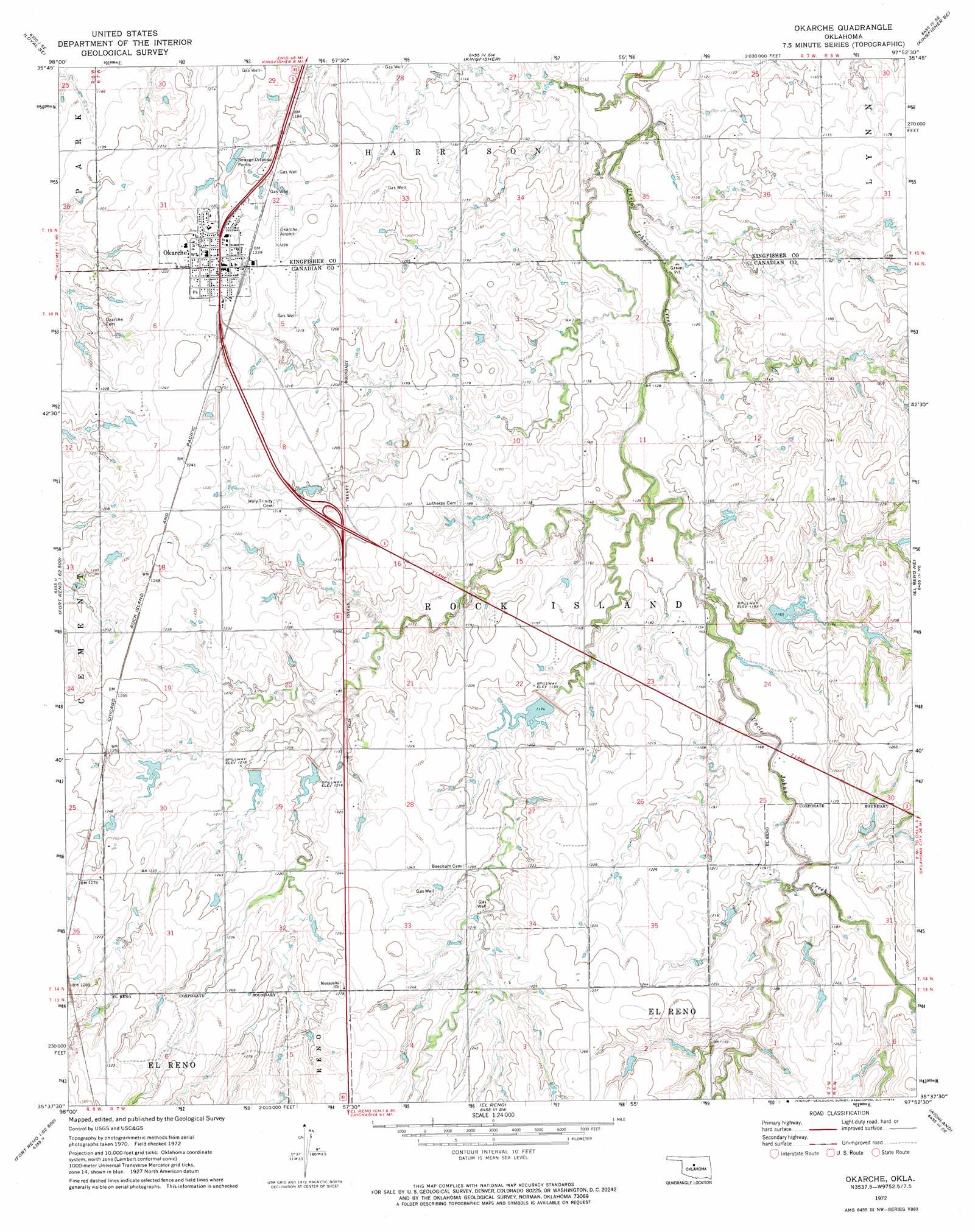
Okarche Topo Map Oklahoma
To zoom in, hover over the map of Okarche
USGS Topo Quad 35097f8 - 1:24,000 scale
| Topo Map Name: | Okarche |
| USGS Topo Quad ID: | 35097f8 |
| Print Size: | ca. 21 1/4" wide x 27" high |
| Southeast Coordinates: | 35.625° N latitude / 97.875° W longitude |
| Map Center Coordinates: | 35.6875° N latitude / 97.9375° W longitude |
| U.S. State: | OK |
| Filename: | o35097f8.jpg |
| Download Map JPG Image: | Okarche topo map 1:24,000 scale |
| Map Type: | Topographic |
| Topo Series: | 7.5´ |
| Map Scale: | 1:24,000 |
| Source of Map Images: | United States Geological Survey (USGS) |
| Alternate Map Versions: |
Okarche OK 1972, updated 1974 Download PDF Buy paper map Okarche OK 2009 Download PDF Buy paper map Okarche OK 2012 Download PDF Buy paper map Okarche OK 2016 Download PDF Buy paper map |
1:24,000 Topo Quads surrounding Okarche
Loyal Nw |
Loyal |
Dover |
Kingfisher Ne |
Crescent Nw |
Omega |
Loyal Se |
Kingfisher |
Kingfisher Se |
Cashion |
Porcupine Butte |
Fort Reno Ne |
Okarche |
El Reno Ne |
Piedmont |
Fort Reno Sw |
Fort Reno |
El Reno |
Richland |
Bethany |
Cogar Nw |
Cogar Ne |
Union City |
Minco Ne |
Mustang |
> Back to 35097e1 at 1:100,000 scale
> Back to 35096a1 at 1:250,000 scale
> Back to U.S. Topo Maps home
Okarche topo map: Gazetteer
Okarche: Airports
Chandler Armory Heliport elevation 364m 1194′Okarche Airport elevation 379m 1243′
Okarche: Dams
Oknoname 017004 Dam elevation 358m 1174′Oknoname 017006 Dam elevation 366m 1200′
Oknoname 017007 Dam elevation 375m 1230′
Uncle John Creek Site 11 Dam elevation 355m 1164′
Uncle John Creek Site 4 Dam elevation 363m 1190′
Uncle John Creek Site 5 Dam elevation 367m 1204′
Uncle John Creek Site 6 Dam elevation 363m 1190′
Uncle John Creek Site 7 Dam elevation 357m 1171′
Uncle John Creek Site 8 Dam elevation 360m 1181′
Uncle John Creek Site 9 Dam elevation 359m 1177′
Okarche: Populated Places
Okarche elevation 379m 1243′Okarche: Reservoirs
Oknoname 4 Lake elevation 358m 1174′Oknoname 6 Lake elevation 366m 1200′
Oknoname Canadian County 7 Lake elevation 375m 1230′
Uncle John Creek Site 11 Reservoir elevation 355m 1164′
Uncle John Creek Site 4 Reservoir elevation 363m 1190′
Uncle John Creek Site 5 Reservoir elevation 367m 1204′
Uncle John Creek Site 6 Reservoir elevation 363m 1190′
Uncle John Creek Site 7 Reservoir elevation 357m 1171′
Uncle John Creek Site 8 Reservoir elevation 360m 1181′
Uncle John Creek Site 9 Reservoir elevation 359m 1177′
Okarche digital topo map on disk
Buy this Okarche topo map showing relief, roads, GPS coordinates and other geographical features, as a high-resolution digital map file on DVD: