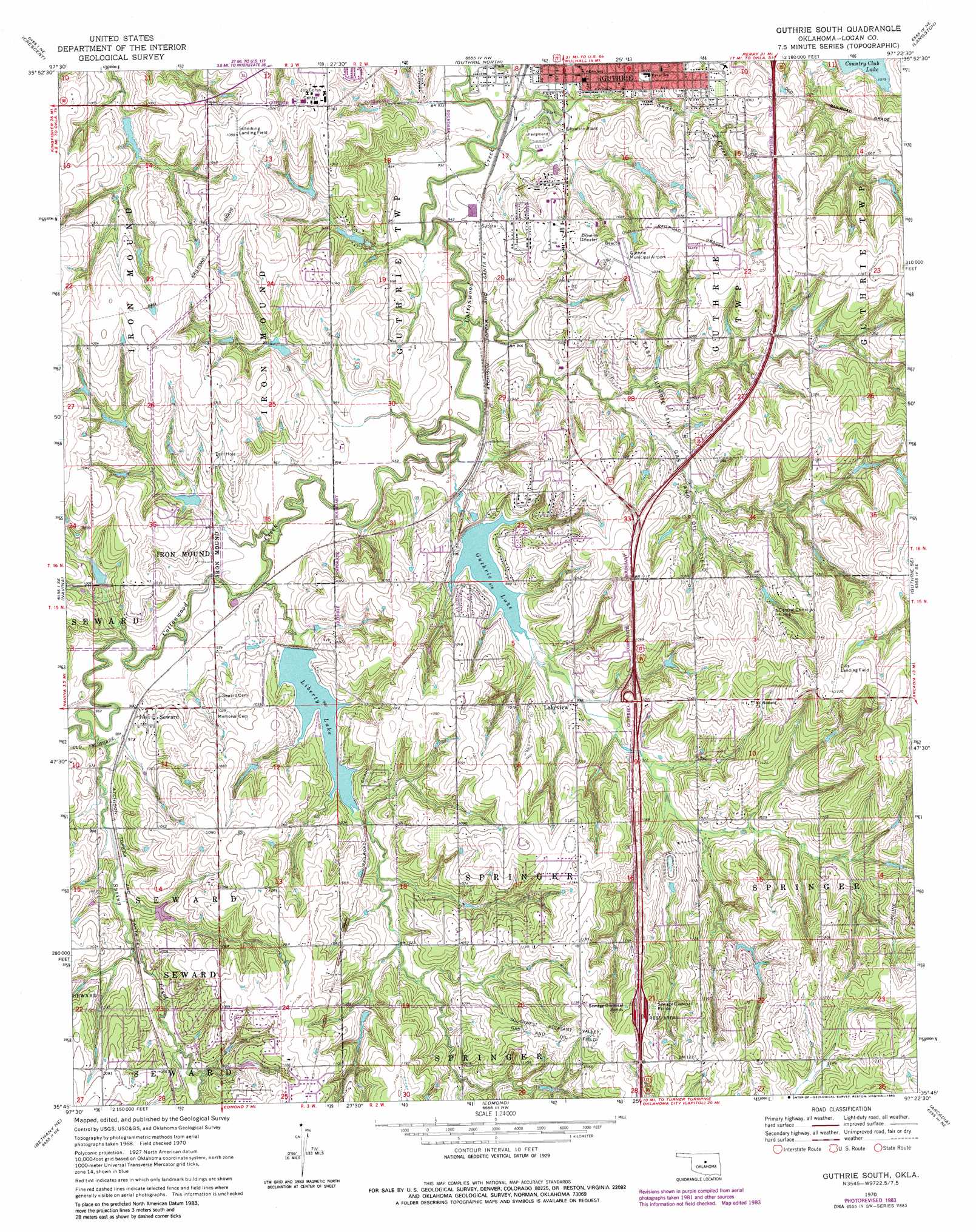
Guthrie South Topo Map Oklahoma
To zoom in, hover over the map of Guthrie South
USGS Topo Quad 35097g4 - 1:24,000 scale
| Topo Map Name: | Guthrie South |
| USGS Topo Quad ID: | 35097g4 |
| Print Size: | ca. 21 1/4" wide x 27" high |
| Southeast Coordinates: | 35.75° N latitude / 97.375° W longitude |
| Map Center Coordinates: | 35.8125° N latitude / 97.4375° W longitude |
| U.S. State: | OK |
| Filename: | o35097g4.jpg |
| Download Map JPG Image: | Guthrie South topo map 1:24,000 scale |
| Map Type: | Topographic |
| Topo Series: | 7.5´ |
| Map Scale: | 1:24,000 |
| Source of Map Images: | United States Geological Survey (USGS) |
| Alternate Map Versions: |
Guthrie South OK 1970, updated 1972 Download PDF Buy paper map Guthrie South OK 1970, updated 1981 Download PDF Buy paper map Guthrie South OK 1970, updated 1983 Download PDF Buy paper map Guthrie South OK 2010 Download PDF Buy paper map Guthrie South OK 2012 Download PDF Buy paper map Guthrie South OK 2016 Download PDF Buy paper map |
1:24,000 Topo Quads surrounding Guthrie South
Lovell |
Bridge Creek |
Mulhall |
Clear Creek |
Stillwater Sw |
Crescent Nw |
Crescent |
Guthrie North |
Langston |
Coyle |
Cashion |
Navina |
Guthrie South |
Guthrie Se |
Meridian |
Piedmont |
Bethany Ne |
Edmond |
Arcadia |
Luther |
Bethany |
Britton |
Spencer |
Jones |
Horseshoe Lake |
> Back to 35097e1 at 1:100,000 scale
> Back to 35096a1 at 1:250,000 scale
> Back to U.S. Topo Maps home
Guthrie South topo map: Gazetteer
Guthrie South: Airports
Ellis/Harvey Airport elevation 368m 1207′Guthrie Municipal Airport elevation 325m 1066′
Myrick Airport elevation 356m 1167′
Guthrie South: Dams
Cabana Club Lake Dam elevation 286m 938′Cottonwood Creek Site 2 Dam elevation 303m 994′
Cottonwood Creek Site 3 Dam elevation 300m 984′
Cottonwood Creek Site 4 Dam elevation 298m 977′
Cottonwood Creek Site 55 Dam elevation 303m 994′
Guthrie City Lake Dam elevation 289m 948′
Liberty Lake Dam elevation 303m 994′
Oknoname 083012 Dam elevation 318m 1043′
Oknoname 083014 Dam elevation 346m 1135′
Oknoname 083015 Dam elevation 339m 1112′
Oknoname 083017 Dam elevation 301m 987′
Oknoname 083023 Dam elevation 308m 1010′
Oknoname 083029 Dam elevation 311m 1020′
Guthrie South: Oilfields
East Guthrie Lake Gas and Oil Field elevation 307m 1007′Southwest Pleasant Valley Gas and Oil Field elevation 357m 1171′
Guthrie South: Populated Places
Lakeview elevation 304m 997′Seward elevation 304m 997′
Guthrie South: Reservoirs
Cabana Club Lake elevation 286m 938′Cottonwood Creek Site 2 Reservoir elevation 303m 994′
Cottonwood Creek Site 3 Reservoir elevation 300m 984′
Cottonwood Creek Site 4 Reservoir elevation 298m 977′
Cottonwood Creek Site 55 Reservoir elevation 303m 994′
Country Club Lake elevation 311m 1020′
Guthrie City Lake elevation 289m 948′
Guthrie Lake elevation 298m 977′
Liberty Lake elevation 304m 997′
Oknoname 083012 Reservoir elevation 318m 1043′
Oknoname 083014 Reservoir elevation 346m 1135′
Oknoname 083015 Reservoir elevation 339m 1112′
Oknoname 083017 Reservoir elevation 301m 987′
Oknoname 083023 Reservoir elevation 308m 1010′
Oknoname 083029 Reservoir elevation 311m 1020′
Guthrie South: Streams
Snake Creek elevation 284m 931′Spring Creek elevation 292m 958′
Guthrie South digital topo map on disk
Buy this Guthrie South topo map showing relief, roads, GPS coordinates and other geographical features, as a high-resolution digital map file on DVD: