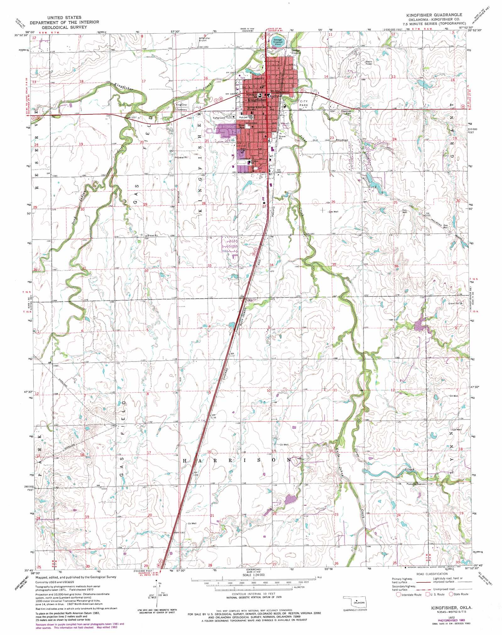
Kingfisher Topo Map Oklahoma
To zoom in, hover over the map of Kingfisher
USGS Topo Quad 35097g8 - 1:24,000 scale
| Topo Map Name: | Kingfisher |
| USGS Topo Quad ID: | 35097g8 |
| Print Size: | ca. 21 1/4" wide x 27" high |
| Southeast Coordinates: | 35.75° N latitude / 97.875° W longitude |
| Map Center Coordinates: | 35.8125° N latitude / 97.9375° W longitude |
| U.S. State: | OK |
| Filename: | o35097g8.jpg |
| Download Map JPG Image: | Kingfisher topo map 1:24,000 scale |
| Map Type: | Topographic |
| Topo Series: | 7.5´ |
| Map Scale: | 1:24,000 |
| Source of Map Images: | United States Geological Survey (USGS) |
| Alternate Map Versions: |
Kingfisher OK 1972, updated 1974 Download PDF Buy paper map Kingfisher OK 1972, updated 1983 Download PDF Buy paper map Kingfisher OK 2009 Download PDF Buy paper map Kingfisher OK 2012 Download PDF Buy paper map Kingfisher OK 2016 Download PDF Buy paper map |
1:24,000 Topo Quads surrounding Kingfisher
Parvin |
Lacey |
Hennessey |
Union |
Lovell |
Loyal Nw |
Loyal |
Dover |
Kingfisher Ne |
Crescent Nw |
Omega |
Loyal Se |
Kingfisher |
Kingfisher Se |
Cashion |
Porcupine Butte |
Fort Reno Ne |
Okarche |
El Reno Ne |
Piedmont |
Fort Reno Sw |
Fort Reno |
El Reno |
Richland |
Bethany |
> Back to 35097e1 at 1:100,000 scale
> Back to 35096a1 at 1:250,000 scale
> Back to U.S. Topo Maps home
Kingfisher topo map: Gazetteer
Kingfisher: Airports
Reherman Airport elevation 336m 1102′Kingfisher: Dams
Kingfisher Sewage Disposal Dam elevation 311m 1020′Oknoname 07309 Dam elevation 330m 1082′
Oknoname 07311 Dam elevation 345m 1131′
Uncle John Creek Site 14 Dam elevation 330m 1082′
Uncle John Creek Site 2 Dam elevation 339m 1112′
Kingfisher: Parks
Shaw Park elevation 332m 1089′Kingfisher: Populated Places
Kingfisher elevation 321m 1053′Kingfisher: Reservoirs
Kingfisher Sewage Disposal Pond elevation 311m 1020′Oknoname 07309 Reservoir elevation 330m 1082′
Oknoname 07311 Reservoir elevation 345m 1131′
Uncle John Creek Site 14 Reservoir elevation 330m 1082′
Uncle John Creek Site 2 Reservoir elevation 339m 1112′
Kingfisher: Streams
Clear Creek elevation 326m 1069′Uncle Johns Creek elevation 316m 1036′
Winter Camp Creek elevation 312m 1023′
Kingfisher digital topo map on disk
Buy this Kingfisher topo map showing relief, roads, GPS coordinates and other geographical features, as a high-resolution digital map file on DVD: