Gracemont Topo Map Oklahoma
To zoom in, hover over the map of Gracemont
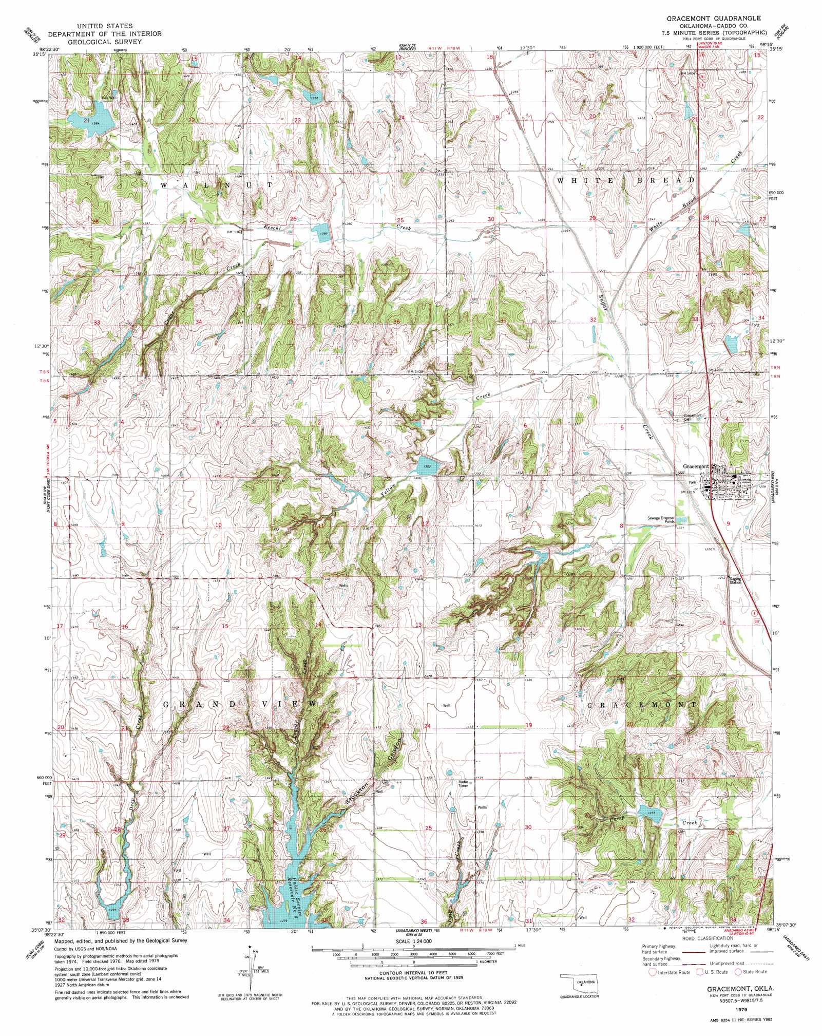
USGS Topo Quad 35098b3 - 1:24,000 scale
| Topo Map Name: | Gracemont |
| USGS Topo Quad ID: | 35098b3 |
| Print Size: | ca. 21 1/4" wide x 27" high |
| Southeast Coordinates: | 35.125° N latitude / 98.25° W longitude |
| Map Center Coordinates: | 35.1875° N latitude / 98.3125° W longitude |
| U.S. State: | OK |
| Filename: | o35098b3.jpg |
| Download Map JPG Image: | Gracemont topo map 1:24,000 scale |
| Map Type: | Topographic |
| Topo Series: | 7.5´ |
| Map Scale: | 1:24,000 |
| Source of Map Images: | United States Geological Survey (USGS) |
| Alternate Map Versions: |
Gracemont OK 1979, updated 1979 Download PDF Buy paper map Gracemont OK 2009 Download PDF Buy paper map Gracemont OK 2013 Download PDF Buy paper map Gracemont OK 2016 Download PDF Buy paper map |
1:24,000 Topo Quads surrounding Gracemont
Eakly Ne |
Rock Mary |
Hinton |
Cogar Nw |
Cogar Ne |
Eakly |
Sickles |
Binger |
Cogar |
Cogar Se |
Alfalfa |
Fort Cobb Dam |
Gracemont |
Anadarko Nw |
Anadarko Ne |
Carnegie |
Fort Cobb |
Anadarko West |
Anadarko East |
Verden |
Alden |
Boone |
Apache |
Cyril |
Laverty |
> Back to 35098a1 at 1:100,000 scale
> Back to 35098a1 at 1:250,000 scale
> Back to U.S. Topo Maps home
Gracemont topo map: Gazetteer
Gracemont: Dams
Sugar Creek Site 1 Dam elevation 388m 1272′Sugar Creek Site 101 Dam elevation 399m 1309′
Sugar Creek Site 102 Dam elevation 393m 1289′
Sugar Creek Site 103 Dam elevation 449m 1473′
Sugar Creek Site 2 Dam elevation 393m 1289′
Sugar Creek Site 3 Dam elevation 397m 1302′
Sugar Creek Site 34 Dam elevation 397m 1302′
Sugar Creek Site 35 Dam elevation 387m 1269′
Sugar Creek Site 37 Dam elevation 409m 1341′
Sugar Creek Site 38 Dam elevation 379m 1243′
Sugar Creek Site 4 Dam elevation 390m 1279′
Sugar Creek Site 4a Dam elevation 409m 1341′
Sugar Creek Site L43 Dam elevation 398m 1305′
Gracemont: Populated Places
Gracemont elevation 378m 1240′Gracemont: Reservoirs
Sugar Creek Site 1 Reservoir elevation 388m 1272′Sugar Creek Site 101 Reservoir elevation 399m 1309′
Sugar Creek Site 102 Reservoir elevation 393m 1289′
Sugar Creek Site 103 Reservoir elevation 449m 1473′
Sugar Creek Site 2 Reservoir elevation 393m 1289′
Sugar Creek Site 3 Reservoir elevation 397m 1302′
Sugar Creek Site 34 Reservoir elevation 397m 1302′
Sugar Creek Site 35 Reservoir elevation 387m 1269′
Sugar Creek Site 37 Reservoir elevation 409m 1341′
Sugar Creek Site 38 Reservoir elevation 379m 1243′
Sugar Creek Site 4 Reservoir elevation 390m 1279′
Sugar Creek Site 4a Reservoir elevation 409m 1341′
Sugar Creek Site L43 Reservoir elevation 398m 1305′
Gracemont: Streams
Cedar Creek elevation 391m 1282′Keechi Creek elevation 374m 1227′
White Bread Creek elevation 374m 1227′
Yellow Creek elevation 368m 1207′
Gracemont: Valleys
Stockton Canyon elevation 388m 1272′Gracemont digital topo map on disk
Buy this Gracemont topo map showing relief, roads, GPS coordinates and other geographical features, as a high-resolution digital map file on DVD: