Fort Cobb Dam Topo Map Oklahoma
To zoom in, hover over the map of Fort Cobb Dam
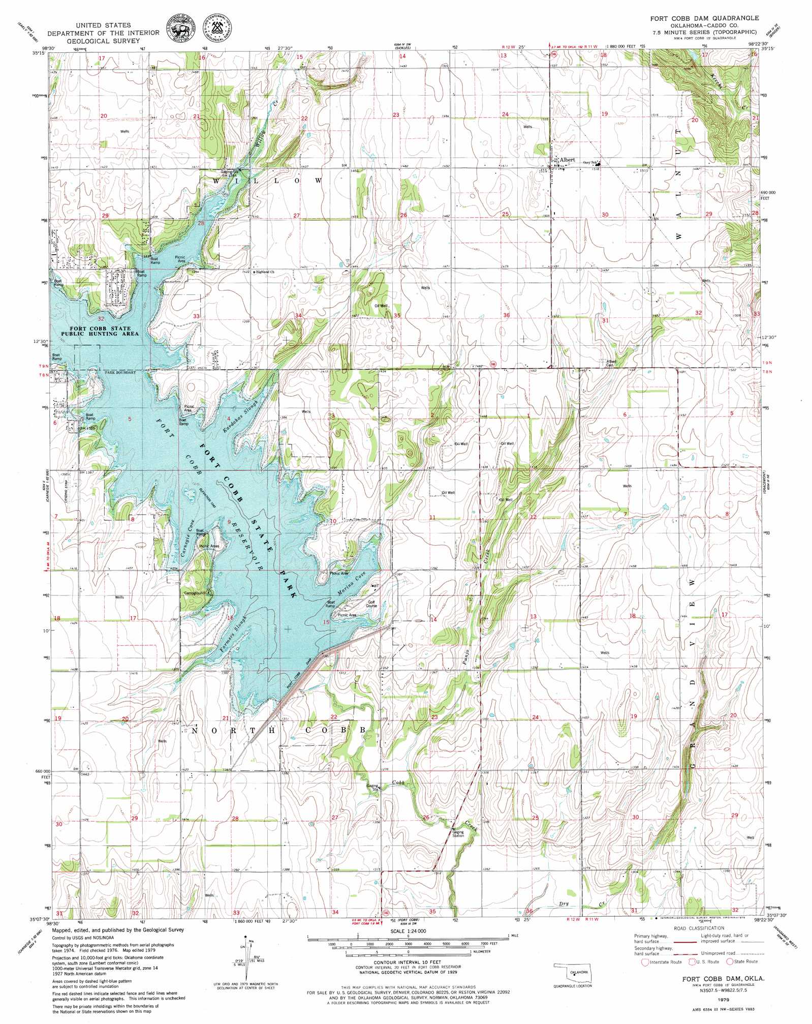
USGS Topo Quad 35098b4 - 1:24,000 scale
| Topo Map Name: | Fort Cobb Dam |
| USGS Topo Quad ID: | 35098b4 |
| Print Size: | ca. 21 1/4" wide x 27" high |
| Southeast Coordinates: | 35.125° N latitude / 98.375° W longitude |
| Map Center Coordinates: | 35.1875° N latitude / 98.4375° W longitude |
| U.S. State: | OK |
| Filename: | o35098b4.jpg |
| Download Map JPG Image: | Fort Cobb Dam topo map 1:24,000 scale |
| Map Type: | Topographic |
| Topo Series: | 7.5´ |
| Map Scale: | 1:24,000 |
| Source of Map Images: | United States Geological Survey (USGS) |
| Alternate Map Versions: |
Fort Cobb Dam OK 1979, updated 1979 Download PDF Buy paper map Fort Cobb Dam OK 2010 Download PDF Buy paper map Fort Cobb Dam OK 2012 Download PDF Buy paper map Fort Cobb Dam OK 2016 Download PDF Buy paper map |
1:24,000 Topo Quads surrounding Fort Cobb Dam
Crowder Lake |
Eakly Ne |
Rock Mary |
Hinton |
Cogar Nw |
Colony |
Eakly |
Sickles |
Binger |
Cogar |
Cowden |
Alfalfa |
Fort Cobb Dam |
Gracemont |
Anadarko Nw |
Stinking Creek |
Carnegie |
Fort Cobb |
Anadarko West |
Anadarko East |
Bally Mountain |
Alden |
Boone |
Apache |
Cyril |
> Back to 35098a1 at 1:100,000 scale
> Back to 35098a1 at 1:250,000 scale
> Back to U.S. Topo Maps home
Fort Cobb Dam topo map: Gazetteer
Fort Cobb Dam: Bays
Carnegie Cove elevation 409m 1341′Farmers Slough elevation 409m 1341′
Kardokas Slough elevation 409m 1341′
Marina Cove elevation 409m 1341′
Fort Cobb Dam: Dams
Fort Cobb Dam elevation 409m 1341′Fort Cobb Dam elevation 415m 1361′
Oknoname 015018 Dam elevation 425m 1394′
Fort Cobb Dam: Parks
Fort Cobb State Park elevation 409m 1341′Fort Cobb State Public Hunting Area elevation 409m 1341′
Fort Cobb Dam: Populated Places
Albert elevation 463m 1519′Nowhere elevation 410m 1345′
Fort Cobb Dam: Reservoirs
Fort Cobb Reservoir elevation 409m 1341′Fort Cobb Reservoir elevation 409m 1341′
Oknaname 015018 Reservoir elevation 425m 1394′
Fort Cobb Dam: Streams
Punjo Creek elevation 387m 1269′Willow Creek elevation 410m 1345′
Fort Cobb Dam digital topo map on disk
Buy this Fort Cobb Dam topo map showing relief, roads, GPS coordinates and other geographical features, as a high-resolution digital map file on DVD: