Hinton Topo Map Oklahoma
To zoom in, hover over the map of Hinton
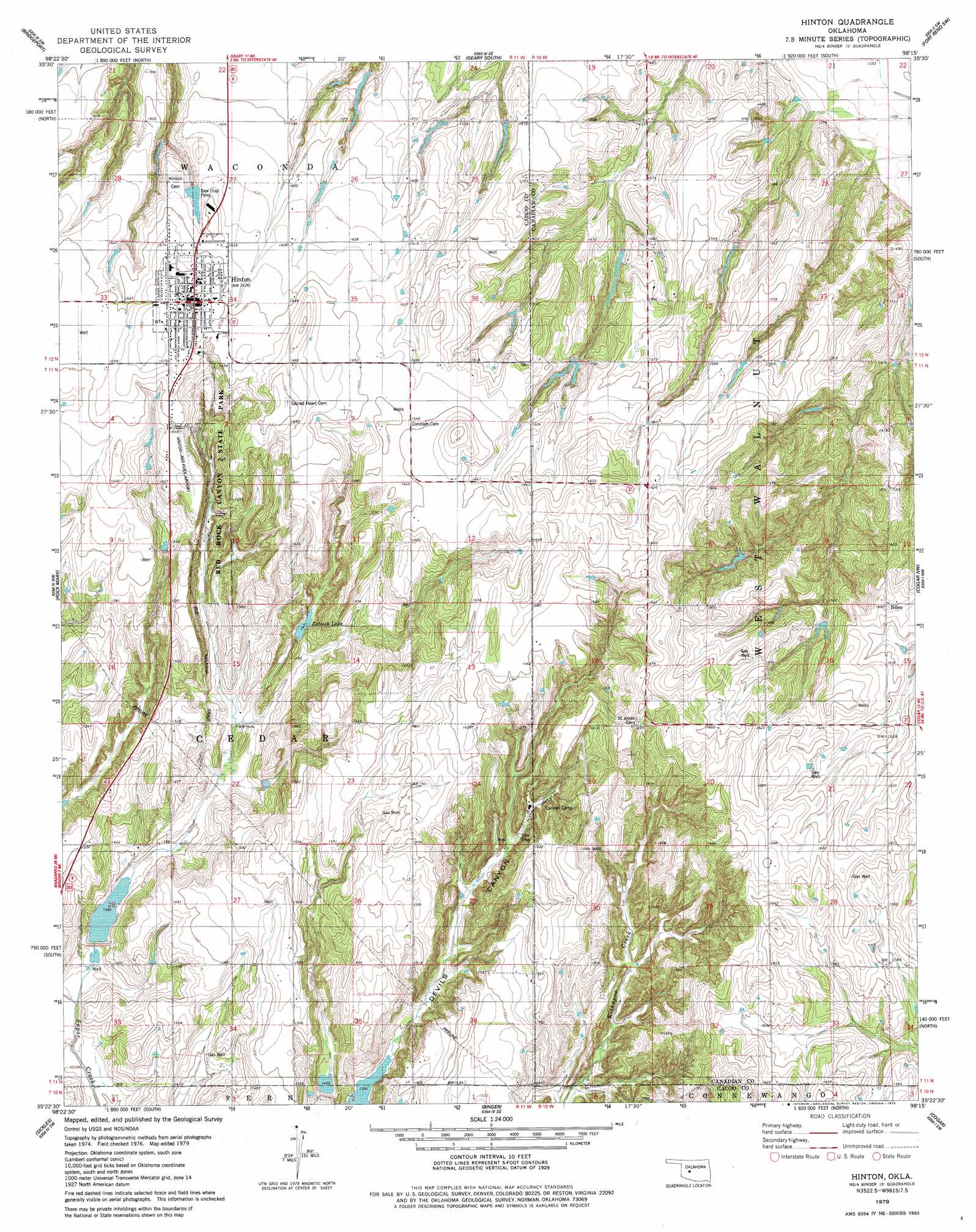
USGS Topo Quad 35098d3 - 1:24,000 scale
| Topo Map Name: | Hinton |
| USGS Topo Quad ID: | 35098d3 |
| Print Size: | ca. 21 1/4" wide x 27" high |
| Southeast Coordinates: | 35.375° N latitude / 98.25° W longitude |
| Map Center Coordinates: | 35.4375° N latitude / 98.3125° W longitude |
| U.S. State: | OK |
| Filename: | o35098d3.jpg |
| Download Map JPG Image: | Hinton topo map 1:24,000 scale |
| Map Type: | Topographic |
| Topo Series: | 7.5´ |
| Map Scale: | 1:24,000 |
| Source of Map Images: | United States Geological Survey (USGS) |
| Alternate Map Versions: |
Hinton OK 1979, updated 1979 Download PDF Buy paper map Hinton OK 2010 Download PDF Buy paper map Hinton OK 2013 Download PDF Buy paper map Hinton OK 2016 Download PDF Buy paper map |
1:24,000 Topo Quads surrounding Hinton
Squaw Creek |
Greenfield |
Geary North |
Porcupine Butte |
Fort Reno Ne |
Hydro |
Bridgeport |
Geary South |
Fort Reno Sw |
Fort Reno |
Eakly Ne |
Rock Mary |
Hinton |
Cogar Nw |
Cogar Ne |
Eakly |
Sickles |
Binger |
Cogar |
Cogar Se |
Alfalfa |
Fort Cobb Dam |
Gracemont |
Anadarko Nw |
Anadarko Ne |
> Back to 35098a1 at 1:100,000 scale
> Back to 35098a1 at 1:250,000 scale
> Back to U.S. Topo Maps home
Hinton topo map: Gazetteer
Hinton: Airports
Red Rock Airport elevation 501m 1643′Hinton: Dams
Fast Runner Site 4 Dam elevation 421m 1381′Fay Abbott Dam elevation 470m 1541′
Hinton Sewage Pond Dam elevation 490m 1607′
Oknoname 015002 Dam elevation 483m 1584′
Oknoname 015003 Dam elevation 467m 1532′
Sugar Creek Site 21 Dam elevation 424m 1391′
Sugar Creek Site 210 Dam elevation 435m 1427′
Sugar Creek Site 41 Dam elevation 520m 1706′
Zobisch Lake Dam elevation 449m 1473′
Hinton: Parks
Red Rock Canyon State Park elevation 480m 1574′Hinton: Populated Places
Hinton elevation 512m 1679′Niles elevation 497m 1630′
Hinton: Reservoirs
Fast Runner Site 4 Reservoir elevation 421m 1381′Fay Abbott Reservoir elevation 470m 1541′
Hinton Sewage Pond elevation 490m 1607′
Oknoname 015002 Reservoir elevation 483m 1584′
Oknoname 015003 Reservoir elevation 467m 1532′
Sugar Creek Site 21 Reservoir elevation 424m 1391′
Sugar Creek Site 210 Reservoir elevation 435m 1427′
Sugar Creek Site 41 Reservoir elevation 520m 1706′
Zobisch Lake elevation 449m 1473′
Hinton digital topo map on disk
Buy this Hinton topo map showing relief, roads, GPS coordinates and other geographical features, as a high-resolution digital map file on DVD: