Fort Reno Topo Map Oklahoma
To zoom in, hover over the map of Fort Reno
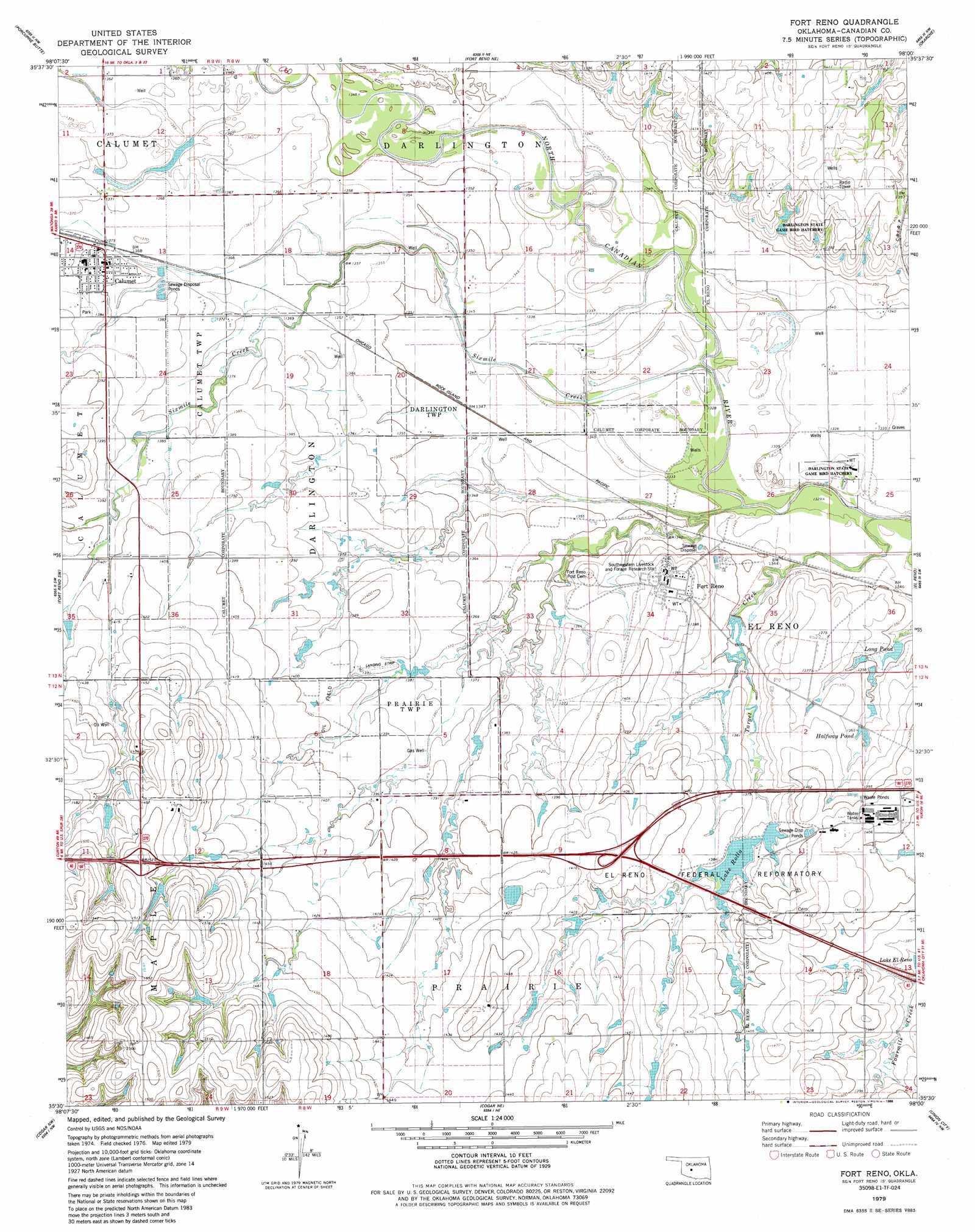
USGS Topo Quad 35098e1 - 1:24,000 scale
| Topo Map Name: | Fort Reno |
| USGS Topo Quad ID: | 35098e1 |
| Print Size: | ca. 21 1/4" wide x 27" high |
| Southeast Coordinates: | 35.5° N latitude / 98° W longitude |
| Map Center Coordinates: | 35.5625° N latitude / 98.0625° W longitude |
| U.S. State: | OK |
| Filename: | o35098e1.jpg |
| Download Map JPG Image: | Fort Reno topo map 1:24,000 scale |
| Map Type: | Topographic |
| Topo Series: | 7.5´ |
| Map Scale: | 1:24,000 |
| Source of Map Images: | United States Geological Survey (USGS) |
| Alternate Map Versions: |
Fort Reno OK 1979, updated 1988 Download PDF Buy paper map Fort Reno OK 2009 Download PDF Buy paper map Fort Reno OK 2012 Download PDF Buy paper map Fort Reno OK 2016 Download PDF Buy paper map |
1:24,000 Topo Quads surrounding Fort Reno
Watonga Se |
Omega |
Loyal Se |
Kingfisher |
Kingfisher Se |
Geary North |
Porcupine Butte |
Fort Reno Ne |
Okarche |
El Reno Ne |
Geary South |
Fort Reno Sw |
Fort Reno |
El Reno |
Richland |
Hinton |
Cogar Nw |
Cogar Ne |
Union City |
Minco Ne |
Binger |
Cogar |
Cogar Se |
Minco |
Tuttle |
> Back to 35098e1 at 1:100,000 scale
> Back to 35098a1 at 1:250,000 scale
> Back to U.S. Topo Maps home
Fort Reno topo map: Gazetteer
Fort Reno: Airports
Brandley Airport elevation 437m 1433′Harman Airport elevation 407m 1335′
Pellar Farm Airport elevation 437m 1433′
Fort Reno: Dams
Oknoname 017002 Dam elevation 415m 1361′Fort Reno: Populated Places
Calumet elevation 421m 1381′Cheyenne and Arapaho Agency (historical) elevation 407m 1335′
Fort Reno: Reservoirs
Halfway Pond elevation 412m 1351′Lake Rolla elevation 418m 1371′
Long Pond elevation 409m 1341′
Oknoname 017002 Reservoir elevation 415m 1361′
Fort Reno: Streams
Sixmile Creek elevation 402m 1318′Target Creek elevation 402m 1318′
Fort Reno digital topo map on disk
Buy this Fort Reno topo map showing relief, roads, GPS coordinates and other geographical features, as a high-resolution digital map file on DVD: