Dempsey Topo Map Oklahoma
To zoom in, hover over the map of Dempsey
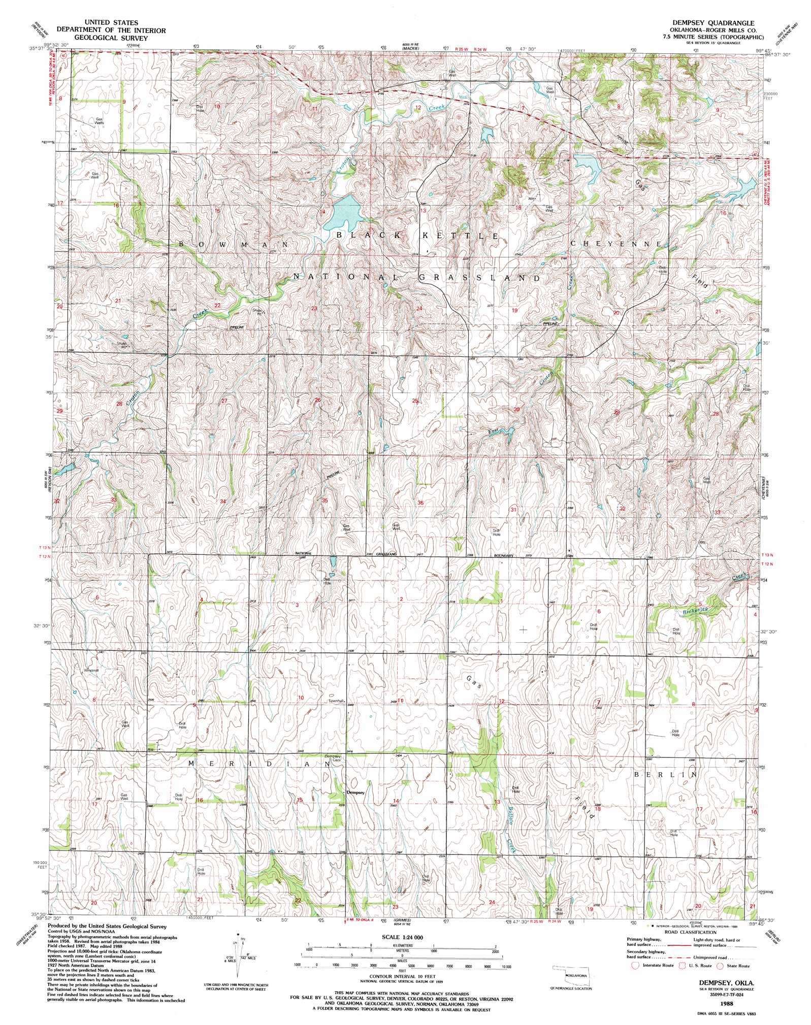
USGS Topo Quad 35099e7 - 1:24,000 scale
| Topo Map Name: | Dempsey |
| USGS Topo Quad ID: | 35099e7 |
| Print Size: | ca. 21 1/4" wide x 27" high |
| Southeast Coordinates: | 35.5° N latitude / 99.75° W longitude |
| Map Center Coordinates: | 35.5625° N latitude / 99.8125° W longitude |
| U.S. State: | OK |
| Filename: | o35099e7.jpg |
| Download Map JPG Image: | Dempsey topo map 1:24,000 scale |
| Map Type: | Topographic |
| Topo Series: | 7.5´ |
| Map Scale: | 1:24,000 |
| Source of Map Images: | United States Geological Survey (USGS) |
| Alternate Map Versions: |
Dempsey OK 1988, updated 1989 Download PDF Buy paper map Dempsey OK 1998, updated 2001 Download PDF Buy paper map Dempsey OK 2011 Download PDF Buy paper map Dempsey OK 2012 Download PDF Buy paper map Dempsey OK 2016 Download PDF Buy paper map |
| FStopo: | US Forest Service topo Dempsey is available: Download FStopo PDF Download FStopo TIF |
1:24,000 Topo Quads surrounding Dempsey
Gem |
Durham |
Crawford |
Roll |
Roll Se |
Hackberry Creek |
Reydon |
Mackie |
Cheyenne Nw |
Strong City |
Allison |
Reydon Sw |
Dempsey |
Cheyenne |
Herring |
Kelton |
Sweetwater |
Grimes |
Berlin |
Baker Lake |
Kelton Se |
Mayfield |
Prentiss |
Sayre |
Doxey |
> Back to 35099e1 at 1:100,000 scale
> Back to 35098a1 at 1:250,000 scale
> Back to U.S. Topo Maps home
Dempsey topo map: Gazetteer
Dempsey: Dams
Broken Leg Creek Site 2 Dam elevation 620m 2034′Broken Leg Creek Site 3 Dam elevation 624m 2047′
Upper Washita Site 57 Dam elevation 666m 2185′
Upper Washita Site 58 Dam elevation 641m 2103′
Upper Washita Site 59 Dam elevation 637m 2089′
Upper Washita Site 60 Dam elevation 642m 2106′
Dempsey: Populated Places
Dempsey elevation 727m 2385′Dempsey: Reservoirs
Broken Leg Creek Site 2 Reservoir elevation 620m 2034′Broken Leg Creek Site 3 Reservoir elevation 624m 2047′
Upper Washita Site 57 Reservoir elevation 666m 2185′
Upper Washita Site 58 Reservoir elevation 641m 2103′
Upper Washita Site 59 Reservoir elevation 637m 2089′
Upper Washita Site 60 Reservoir elevation 642m 2106′
Dempsey: Streams
East Croton Creek elevation 625m 2050′Dempsey digital topo map on disk
Buy this Dempsey topo map showing relief, roads, GPS coordinates and other geographical features, as a high-resolution digital map file on DVD: