Mcclure Topo Map Oklahoma
To zoom in, hover over the map of Mcclure
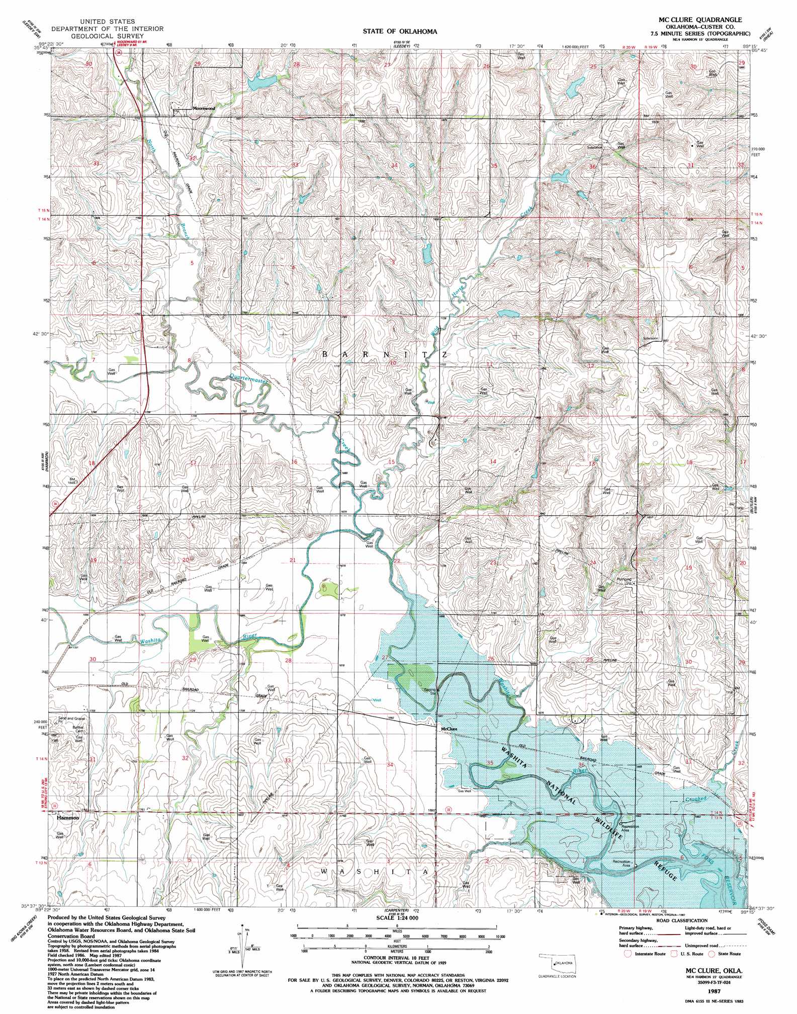
USGS Topo Quad 35099f3 - 1:24,000 scale
| Topo Map Name: | Mcclure |
| USGS Topo Quad ID: | 35099f3 |
| Print Size: | ca. 21 1/4" wide x 27" high |
| Southeast Coordinates: | 35.625° N latitude / 99.25° W longitude |
| Map Center Coordinates: | 35.6875° N latitude / 99.3125° W longitude |
| U.S. State: | OK |
| Filename: | o35099f3.jpg |
| Download Map JPG Image: | Mcclure topo map 1:24,000 scale |
| Map Type: | Topographic |
| Topo Series: | 7.5´ |
| Map Scale: | 1:24,000 |
| Source of Map Images: | United States Geological Survey (USGS) |
| Alternate Map Versions: |
Mc Clure OK 1987, updated 1987 Download PDF Buy paper map McClure OK 2010 Download PDF Buy paper map McClure OK 2012 Download PDF Buy paper map McClure OK 2016 Download PDF Buy paper map |
1:24,000 Topo Quads surrounding Mcclure
Roll Ne |
Flying Creek |
Trail |
Webb |
Aledo Nw |
Roll Se |
Leedey Sw |
Leedey |
Rhea |
Aledo |
Strong City |
Hammon |
Mcclure |
Butler |
Anthon |
Herring |
Big Kiowa Creek |
Carpenter |
Foss Dam |
Stafford |
Baker Lake |
Elk City |
Canute |
Foss |
Dill City Ne |
> Back to 35099e1 at 1:100,000 scale
> Back to 35098a1 at 1:250,000 scale
> Back to U.S. Topo Maps home
Mcclure topo map: Gazetteer
Mcclure: Dams
Oknoname 039001 Dam elevation 563m 1847′Quartermaster Creek Site 28 Dam elevation 531m 1742′
Quartermaster Creek Site 29 Dam elevation 531m 1742′
Quartermaster Creek Site 30 Dam elevation 541m 1774′
Quartermaster Site 25 Dam elevation 544m 1784′
Quartermaster Site 27 Dam elevation 545m 1788′
Mcclure: Populated Places
McClure elevation 509m 1669′Moorewood elevation 557m 1827′
Mcclure: Reservoirs
Oknoname 039001 Reservoir elevation 563m 1847′Quartermaster Creek Site 28 Reservoir elevation 531m 1742′
Quartermaster Creek Site 29 Reservoir elevation 531m 1742′
Quartermaster Creek Site 30 Reservoir elevation 541m 1774′
Quartermaster Site 25 Reservoir elevation 544m 1784′
Quartermaster Site 27 Reservoir elevation 545m 1788′
Mcclure: Streams
North Branch Quartermaster Creek elevation 517m 1696′Quartermaster Creek elevation 511m 1676′
White Shield Creek elevation 515m 1689′
Wild Horse Creek elevation 513m 1683′
Mcclure digital topo map on disk
Buy this Mcclure topo map showing relief, roads, GPS coordinates and other geographical features, as a high-resolution digital map file on DVD: