Crawford Topo Map Oklahoma
To zoom in, hover over the map of Crawford
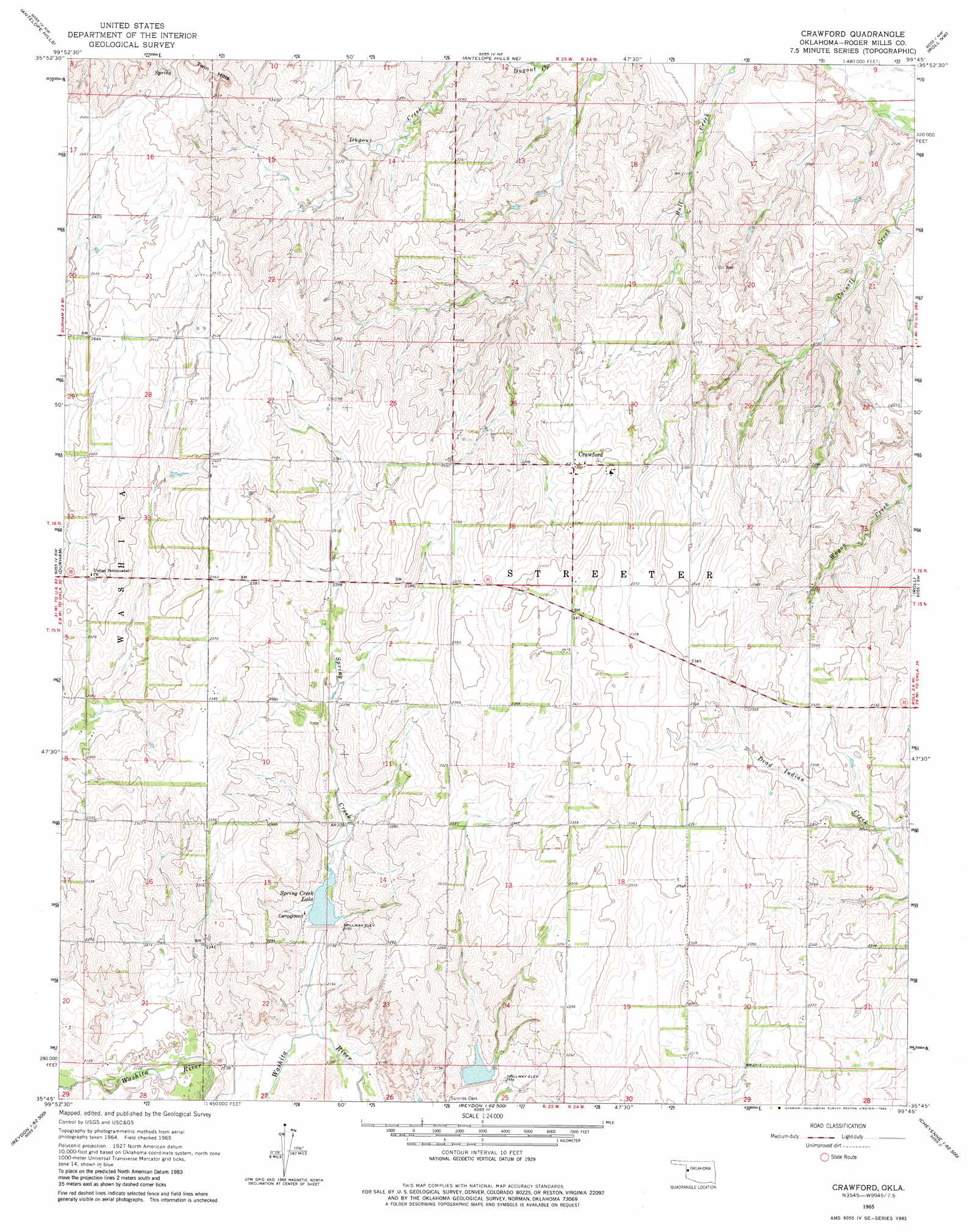
USGS Topo Quad 35099g7 - 1:24,000 scale
| Topo Map Name: | Crawford |
| USGS Topo Quad ID: | 35099g7 |
| Print Size: | ca. 21 1/4" wide x 27" high |
| Southeast Coordinates: | 35.75° N latitude / 99.75° W longitude |
| Map Center Coordinates: | 35.8125° N latitude / 99.8125° W longitude |
| U.S. State: | OK |
| Filename: | o35099g7.jpg |
| Download Map JPG Image: | Crawford topo map 1:24,000 scale |
| Map Type: | Topographic |
| Topo Series: | 7.5´ |
| Map Scale: | 1:24,000 |
| Source of Map Images: | United States Geological Survey (USGS) |
| Alternate Map Versions: |
Crawford OK 1965, updated 1967 Download PDF Buy paper map Crawford OK 1998, updated 2001 Download PDF Buy paper map Crawford OK 2011 Download PDF Buy paper map Crawford OK 2012 Download PDF Buy paper map Crawford OK 2016 Download PDF Buy paper map |
| FStopo: | US Forest Service topo Crawford is available: Download FStopo PDF Download FStopo TIF |
1:24,000 Topo Quads surrounding Crawford
Higgins South |
Arnett Sw |
Arnett Se |
Harmon Sw |
Harmon Se |
Dreyfoos |
Antelope Hills |
Antelope Hills Ne |
Roll Nw |
Roll Ne |
Gem |
Durham |
Crawford |
Roll |
Roll Se |
Hackberry Creek |
Reydon |
Mackie |
Cheyenne Nw |
Strong City |
Allison |
Reydon Sw |
Dempsey |
Cheyenne |
Herring |
> Back to 35099e1 at 1:100,000 scale
> Back to 35098a1 at 1:250,000 scale
> Back to U.S. Topo Maps home
Crawford topo map: Gazetteer
Crawford: Dams
Upper Washita Site 42 Dam elevation 663m 2175′Upper Washita Site 43 Dam elevation 651m 2135′
Crawford: Populated Places
Crawford elevation 710m 2329′Crawford: Reservoirs
Spring Creek Lake elevation 665m 2181′Upper Washita Site 42 Reservoir elevation 663m 2175′
Upper Washita Site 43 Reservoir elevation 651m 2135′
Crawford: Streams
Spring Creek elevation 643m 2109′Crawford: Summits
Twin Hills elevation 776m 2545′Crawford digital topo map on disk
Buy this Crawford topo map showing relief, roads, GPS coordinates and other geographical features, as a high-resolution digital map file on DVD: