Durham Topo Map Oklahoma
To zoom in, hover over the map of Durham
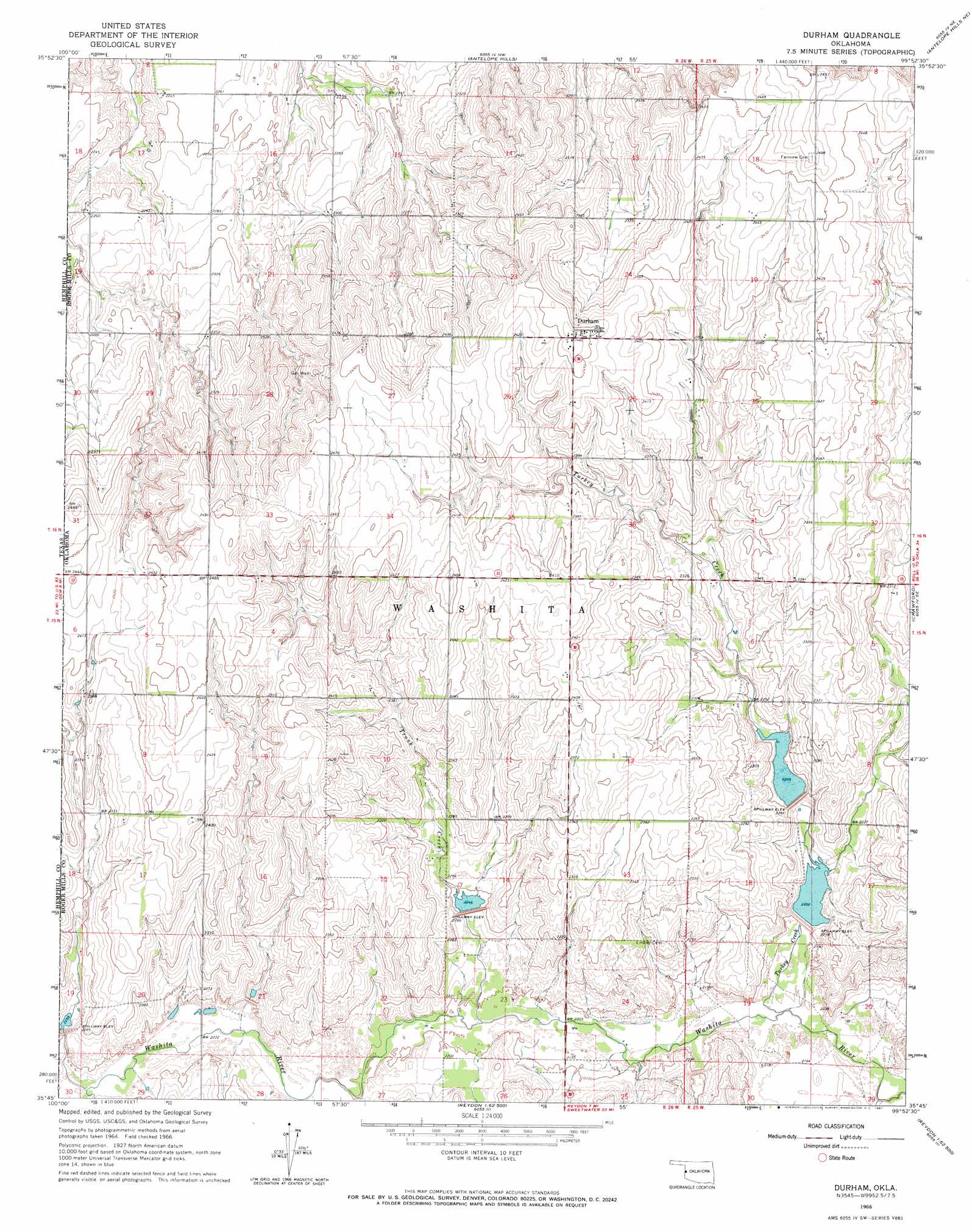
USGS Topo Quad 35099g8 - 1:24,000 scale
| Topo Map Name: | Durham |
| USGS Topo Quad ID: | 35099g8 |
| Print Size: | ca. 21 1/4" wide x 27" high |
| Southeast Coordinates: | 35.75° N latitude / 99.875° W longitude |
| Map Center Coordinates: | 35.8125° N latitude / 99.9375° W longitude |
| U.S. State: | OK |
| Filename: | o35099g8.jpg |
| Download Map JPG Image: | Durham topo map 1:24,000 scale |
| Map Type: | Topographic |
| Topo Series: | 7.5´ |
| Map Scale: | 1:24,000 |
| Source of Map Images: | United States Geological Survey (USGS) |
| Alternate Map Versions: |
Durham OK 1966, updated 1967 Download PDF Buy paper map Durham OK 1998, updated 2001 Download PDF Buy paper map Durham OK 2011 Download PDF Buy paper map Durham OK 2012 Download PDF Buy paper map Durham OK 2016 Download PDF Buy paper map |
| FStopo: | US Forest Service topo Durham is available: Download FStopo PDF Download FStopo TIF |
1:24,000 Topo Quads surrounding Durham
Coburn |
Higgins South |
Arnett Sw |
Arnett Se |
Harmon Sw |
Lake Marvin |
Dreyfoos |
Antelope Hills |
Antelope Hills Ne |
Roll Nw |
Blue Ridge School |
Gem |
Durham |
Crawford |
Roll |
Lake June |
Hackberry Creek |
Reydon |
Mackie |
Cheyenne Nw |
Allison Sw |
Allison |
Reydon Sw |
Dempsey |
Cheyenne |
> Back to 35099e1 at 1:100,000 scale
> Back to 35098a1 at 1:250,000 scale
> Back to U.S. Topo Maps home
Durham topo map: Gazetteer
Durham: Dams
Upper Washita Site 103 Dam elevation 734m 2408′Upper Washita Site 104 Dam elevation 716m 2349′
Upper Washita Site 33 Dam elevation 689m 2260′
Upper Washita Site 34 Dam elevation 679m 2227′
Upper Washita Site 38 Dam elevation 667m 2188′
Upper Washita Site 39 Dam elevation 683m 2240′
Upper Washita Site 40 Dam elevation 672m 2204′
Durham: Populated Places
Durham elevation 753m 2470′Durham: Reservoirs
Upper Washita Site 103 Reservoir elevation 734m 2408′Upper Washita Site 104 Reservoir elevation 716m 2349′
Upper Washita Site 33 Reservoir elevation 689m 2260′
Upper Washita Site 34 Reservoir elevation 679m 2227′
Upper Washita Site 38 Reservoir elevation 667m 2188′
Upper Washita Site 39 Reservoir elevation 683m 2240′
Upper Washita Site 40 Reservoir elevation 672m 2204′
Durham: Streams
Trunk Creek elevation 668m 2191′Turkey Creek elevation 659m 2162′
Durham digital topo map on disk
Buy this Durham topo map showing relief, roads, GPS coordinates and other geographical features, as a high-resolution digital map file on DVD: