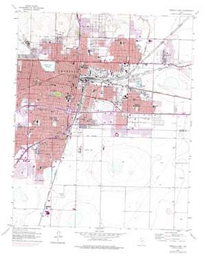
Amarillo East Topo Map Texas
To zoom in, hover over the map of Amarillo East
USGS Topo Quad 35101b7 - 1:24,000 scale
| Topo Map Name: | Amarillo East |
| USGS Topo Quad ID: | 35101b7 |
| Print Size: | ca. 21 1/4" wide x 27" high |
| Southeast Coordinates: | 35.125° N latitude / 101.75° W longitude |
| Map Center Coordinates: | 35.1875° N latitude / 101.8125° W longitude |
| U.S. State: | TX |
| Filename: | o35101b7.jpg |
| Download Map JPG Image: | Amarillo East topo map 1:24,000 scale |
| Map Type: | Topographic |
| Topo Series: | 7.5´ |
| Map Scale: | 1:24,000 |
| Source of Map Images: | United States Geological Survey (USGS) |
| Alternate Map Versions: |
Amarillo East TX 1956, updated 1957 Download PDF Buy paper map Amarillo East TX 1956, updated 1968 Download PDF Buy paper map Amarillo East TX 1956, updated 1975 Download PDF Buy paper map Amarillo East TX 2010 Download PDF Buy paper map Amarillo East TX 2012 Download PDF Buy paper map Amarillo East TX 2016 Download PDF Buy paper map |
1:24,000 Topo Quads surrounding Amarillo East
> Back to 35101a1 at 1:100,000 scale
> Back to 35100a1 at 1:250,000 scale
> Back to U.S. Topo Maps home
Amarillo East topo map: Gazetteer
Amarillo East: Airports
Osage Airpark elevation 1100m 3608′Palo Duro Airport elevation 1107m 3631′
Tradewind Airport elevation 1108m 3635′
Amarillo East: Dams
Amarillo Terminal Reservoir Levee elevation 1113m 3651′Amarillo East: Lakes
Amarillo Lake elevation 1101m 3612′Amarillo East: Mines
Caliche Pits elevation 1087m 3566′Amarillo East: Parks
Austin Park elevation 1108m 3635′Benton Park elevation 1110m 3641′
Bones Hooks Park elevation 1105m 3625′
Dick Bivins Stadium elevation 1110m 3641′
Eakle Park elevation 1119m 3671′
East Park elevation 1110m 3641′
El Alamo Park elevation 1109m 3638′
Elwood Park elevation 1119m 3671′
Forest Hill Park elevation 1116m 3661′
Gene Howe Park elevation 1104m 3622′
Glenwood Park elevation 1112m 3648′
Hines Park elevation 1104m 3622′
Martin Road Park elevation 1104m 3622′
Memorial Park elevation 1123m 3684′
North Height Park elevation 1095m 3592′
Potter County Memorial Stadium elevation 1112m 3648′
Rattlers Civic Arena elevation 1117m 3664′
San Jacinto Park elevation 1108m 3635′
Sandborn Park elevation 1117m 3664′
South Lawn Park elevation 1114m 3654′
Southeast Park elevation 1088m 3569′
Thompson Park elevation 1087m 3566′
Tri-State Fairgrounds Arena elevation 1104m 3622′
Will Rogers Park elevation 1117m 3664′
Amarillo East: Populated Places
Amarillo elevation 1118m 3667′Dumas Junction elevation 1114m 3654′
Zita elevation 1114m 3654′
Amarillo East: Reservoirs
Amarillo Terminal Reservoir elevation 1113m 3651′Amarillo East digital topo map on disk
Buy this Amarillo East topo map showing relief, roads, GPS coordinates and other geographical features, as a high-resolution digital map file on DVD:


