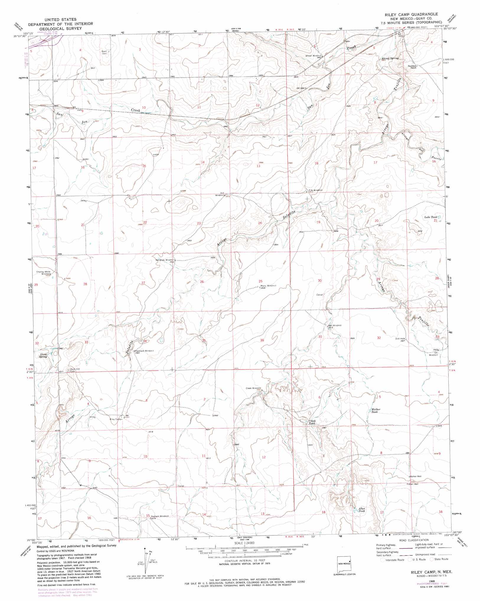
Riley Camp Topo Map New Mexico
To zoom in, hover over the map of Riley Camp
USGS Topo Quad 35103a2 - 1:24,000 scale
| Topo Map Name: | Riley Camp |
| USGS Topo Quad ID: | 35103a2 |
| Print Size: | ca. 21 1/4" wide x 27" high |
| Southeast Coordinates: | 35° N latitude / 103.125° W longitude |
| Map Center Coordinates: | 35.0625° N latitude / 103.1875° W longitude |
| U.S. State: | NM |
| Filename: | o35103a2.jpg |
| Download Map JPG Image: | Riley Camp topo map 1:24,000 scale |
| Map Type: | Topographic |
| Topo Series: | 7.5´ |
| Map Scale: | 1:24,000 |
| Source of Map Images: | United States Geological Survey (USGS) |
| Alternate Map Versions: |
Riley Camp NM 1968, updated 1971 Download PDF Buy paper map Riley Camp NM 1968, updated 1982 Download PDF Buy paper map Riley Camp NM 2010 Download PDF Buy paper map Riley Camp NM 2013 Download PDF Buy paper map Riley Camp NM 2017 Download PDF Buy paper map |
1:24,000 Topo Quads surrounding Riley Camp
Logan South |
Tuscocoillo Canyon |
Blue Hole |
Martin Draw |
Signal Spring |
San Jon Nw |
Porter |
Bard |
Glenrio |
Moser Ranch |
Bedford Hill |
San Jon |
Riley Camp |
Rock Camp |
Sand Point |
Apache Canyon |
Wheatland |
Day Canyon |
Endee Hill |
Mustang Lake |
Grady Sw |
Grady |
Broadview |
Bellview |
Garcia Lake |
> Back to 35103a1 at 1:100,000 scale
> Back to 35102a1 at 1:250,000 scale
> Back to U.S. Topo Maps home
Riley Camp topo map: Gazetteer
Riley Camp: Lakes
Tank Lake elevation 1195m 3920′Riley Camp: Populated Places
Allen (historical) elevation 1221m 4005′Riley Camp: Post Offices
Allen Post Office (historical) elevation 1221m 4005′Riley Camp: Reservoirs
Allen Tank elevation 1236m 4055′Creek Tank elevation 1220m 4002′
Walker Tank elevation 1207m 3959′
Riley Camp: Springs
Alamo Spring elevation 1168m 3832′Llano Spring elevation 1219m 3999′
Riley Camp: Streams
Arroyo del Puerto elevation 1172m 3845′Arroyo Saladito elevation 1177m 3861′
Arroyo Trujillo elevation 1165m 3822′
San Jon Creek elevation 1165m 3822′
Riley Camp: Wells
05200 Water Well elevation 1213m 3979′05202 Water Well elevation 1209m 3966′
05203 Water Well elevation 1214m 3982′
05207 Water Well elevation 1202m 3943′
05209 Water Well elevation 1202m 3943′
05211 Water Well elevation 1219m 3999′
05213 Water Well elevation 1219m 3999′
05214 Water Well elevation 1213m 3979′
05216 Water Well elevation 1217m 3992′
Allen Well elevation 1221m 4005′
Walker Well elevation 1219m 3999′
Riley Camp digital topo map on disk
Buy this Riley Camp topo map showing relief, roads, GPS coordinates and other geographical features, as a high-resolution digital map file on DVD: