Glenrio Topo Map New Mexico
To zoom in, hover over the map of Glenrio
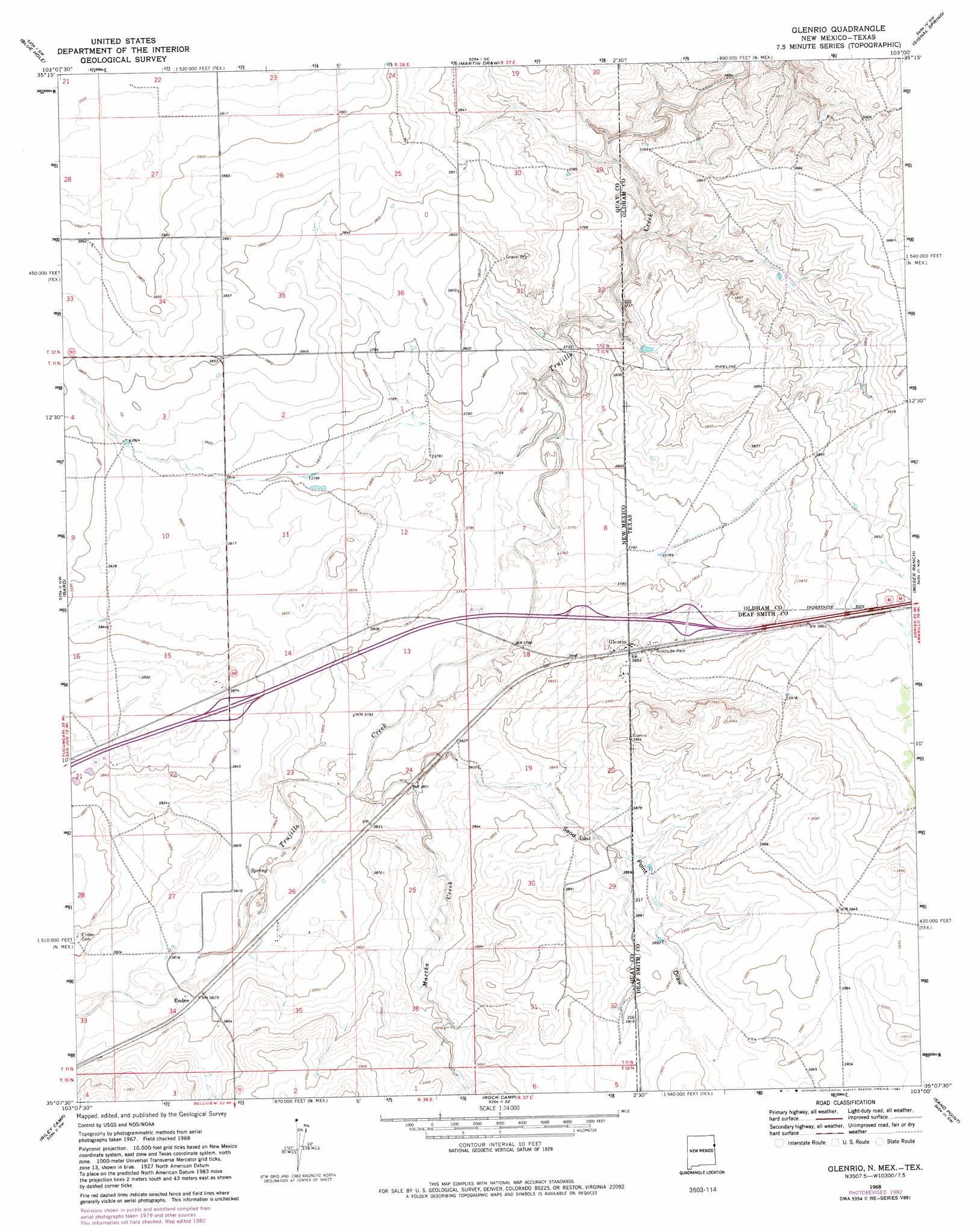
USGS Topo Quad 35103b1 - 1:24,000 scale
| Topo Map Name: | Glenrio |
| USGS Topo Quad ID: | 35103b1 |
| Print Size: | ca. 21 1/4" wide x 27" high |
| Southeast Coordinates: | 35.125° N latitude / 103° W longitude |
| Map Center Coordinates: | 35.1875° N latitude / 103.0625° W longitude |
| U.S. States: | NM, TX |
| Filename: | o35103b1.jpg |
| Download Map JPG Image: | Glenrio topo map 1:24,000 scale |
| Map Type: | Topographic |
| Topo Series: | 7.5´ |
| Map Scale: | 1:24,000 |
| Source of Map Images: | United States Geological Survey (USGS) |
| Alternate Map Versions: |
Glenrio NM 1968, updated 1971 Download PDF Buy paper map Glenrio NM 1968, updated 1982 Download PDF Buy paper map Glenrio NM 2010 Download PDF Buy paper map Glenrio NM 2013 Download PDF Buy paper map Glenrio NM 2017 Download PDF Buy paper map |
1:24,000 Topo Quads surrounding Glenrio
Logan Ne |
Cammak Camp |
Sanchez Springs |
Trujillo Camp |
Vat Camp |
Tuscocoillo Canyon |
Blue Hole |
Martin Draw |
Signal Spring |
Signal Spring Se |
Porter |
Bard |
Glenrio |
Moser Ranch |
Boise |
San Jon |
Riley Camp |
Rock Camp |
Sand Point |
Norton Lake |
Wheatland |
Day Canyon |
Endee Hill |
Mustang Lake |
Walcott |
> Back to 35103a1 at 1:100,000 scale
> Back to 35102a1 at 1:250,000 scale
> Back to U.S. Topo Maps home
Glenrio topo map: Gazetteer
Glenrio: Populated Places
Endee elevation 1165m 3822′Glenrio elevation 1175m 3854′
Glenrio: Post Offices
Endee Post Office (historical) elevation 1167m 3828′Glenrio Post Office elevation 1160m 3805′
Glenrio: Streams
Martha Creek elevation 1179m 3868′Martha Creek elevation 1156m 3792′
Glenrio: Valleys
Sand Point Draw elevation 1159m 3802′Sand Point Draw elevation 1159m 3802′
Glenrio digital topo map on disk
Buy this Glenrio topo map showing relief, roads, GPS coordinates and other geographical features, as a high-resolution digital map file on DVD: