Porter Topo Map New Mexico
To zoom in, hover over the map of Porter
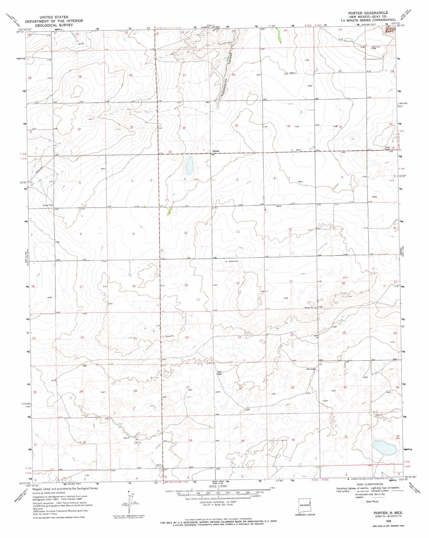
USGS Topo Quad 35103b3 - 1:24,000 scale
| Topo Map Name: | Porter |
| USGS Topo Quad ID: | 35103b3 |
| Print Size: | ca. 21 1/4" wide x 27" high |
| Southeast Coordinates: | 35.125° N latitude / 103.25° W longitude |
| Map Center Coordinates: | 35.1875° N latitude / 103.3125° W longitude |
| U.S. State: | NM |
| Filename: | o35103b3.jpg |
| Download Map JPG Image: | Porter topo map 1:24,000 scale |
| Map Type: | Topographic |
| Topo Series: | 7.5´ |
| Map Scale: | 1:24,000 |
| Source of Map Images: | United States Geological Survey (USGS) |
| Alternate Map Versions: |
Porter NM 1968, updated 1971 Download PDF Buy paper map Porter NM 2010 Download PDF Buy paper map Porter NM 2013 Download PDF Buy paper map Porter NM 2017 Download PDF Buy paper map |
1:24,000 Topo Quads surrounding Porter
Montesito Creek |
Logan North |
Logan Ne |
Cammak Camp |
Sanchez Springs |
Hudson |
Logan South |
Tuscocoillo Canyon |
Blue Hole |
Martin Draw |
Lesbia |
San Jon Nw |
Porter |
Bard |
Glenrio |
Tucumcari Se |
Bedford Hill |
San Jon |
Riley Camp |
Rock Camp |
Norton |
Apache Canyon |
Wheatland |
Day Canyon |
Endee Hill |
> Back to 35103a1 at 1:100,000 scale
> Back to 35102a1 at 1:250,000 scale
> Back to U.S. Topo Maps home
Porter topo map: Gazetteer
Porter: Populated Places
Porter elevation 1246m 4087′Porter: Post Offices
Anniston Post Office (historical) elevation 1248m 4094′Porter Post Office (historical) elevation 1246m 4087′
Porter: Wells
05206 Water Well elevation 1224m 4015′05398 Water Well elevation 1243m 4078′
05399 Water Well elevation 1238m 4061′
05400 Water Well elevation 1236m 4055′
05401 Water Well elevation 1255m 4117′
05402 Water Well elevation 1247m 4091′
05403 Water Well elevation 1247m 4091′
05404 Water Well elevation 1252m 4107′
05405 Water Well elevation 1246m 4087′
05406 Water Well elevation 1246m 4087′
05418 Water Well elevation 1243m 4078′
05419 Water Well elevation 1244m 4081′
05535 Water Well elevation 1254m 4114′
05536 Water Well elevation 1247m 4091′
05537 Water Well elevation 1253m 4110′
05538 Water Well elevation 1252m 4107′
05539 Water Well elevation 1252m 4107′
05540 Water Well elevation 1252m 4107′
05541 Water Well elevation 1253m 4110′
05548 Water Well elevation 1244m 4081′
05549 Water Well elevation 1239m 4064′
05557 Water Well elevation 1228m 4028′
05558 Water Well elevation 1228m 4028′
05560 Water Well elevation 1224m 4015′
05570 Water Well elevation 1241m 4071′
Porter digital topo map on disk
Buy this Porter topo map showing relief, roads, GPS coordinates and other geographical features, as a high-resolution digital map file on DVD: