Chinaberry Canyon Topo Map New Mexico
To zoom in, hover over the map of Chinaberry Canyon
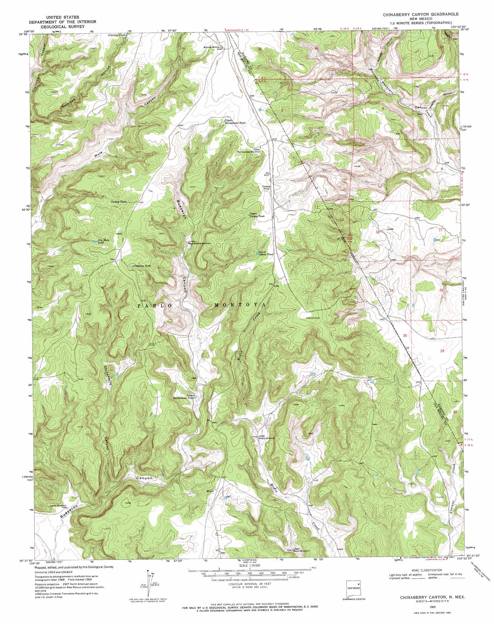
USGS Topo Quad 35103f8 - 1:24,000 scale
| Topo Map Name: | Chinaberry Canyon |
| USGS Topo Quad ID: | 35103f8 |
| Print Size: | ca. 21 1/4" wide x 27" high |
| Southeast Coordinates: | 35.625° N latitude / 103.875° W longitude |
| Map Center Coordinates: | 35.6875° N latitude / 103.9375° W longitude |
| U.S. State: | NM |
| Filename: | o35103f8.jpg |
| Download Map JPG Image: | Chinaberry Canyon topo map 1:24,000 scale |
| Map Type: | Topographic |
| Topo Series: | 7.5´ |
| Map Scale: | 1:24,000 |
| Source of Map Images: | United States Geological Survey (USGS) |
| Alternate Map Versions: |
Chinaberry Canyon NM 1969, updated 1972 Download PDF Buy paper map Chinaberry Canyon NM 2010 Download PDF Buy paper map Chinaberry Canyon NM 2013 Download PDF Buy paper map Chinaberry Canyon NM 2017 Download PDF Buy paper map |
1:24,000 Topo Quads surrounding Chinaberry Canyon
Roy |
Kansas Valley Lake |
Sabino |
Albert |
Bueyeros |
La Cinta Canyon |
Solano |
Mosquero |
Arroyo Del Alamo |
Circle Bar Ranch |
Montoya Point |
Waggoner Ranch |
Chinaberry Canyon |
Salitre Canyon |
Buffalo Springs |
Minese Mesa |
Bell Ranch |
Campana |
Alamosa Canyon |
Gallegos |
Conchas Dam |
La Cinta Mesa |
Carpenter Mesa Nw |
Medina Mesa |
Hampton Ranch |
> Back to 35103e1 at 1:100,000 scale
> Back to 35102a1 at 1:250,000 scale
> Back to U.S. Topo Maps home
Chinaberry Canyon topo map: Gazetteer
Chinaberry Canyon: Mines
Polita Number Two elevation 1416m 4645′Chinaberry Canyon: Reservoirs
Antelope Tank elevation 1649m 5410′Cimaron Tank elevation 1615m 5298′
Dry Mule Tank elevation 1601m 5252′
Lower Cabeza Tank elevation 1605m 5265′
Lower Rattlesnake Tank elevation 1462m 4796′
Turkey Tank elevation 1616m 5301′
Upper Cabeza Tank elevation 1620m 5314′
Upper Rattlesnake Tank elevation 1655m 5429′
Chinaberry Canyon: Valleys
Antelope Canyon elevation 1534m 5032′Chinaberry Canyon elevation 1407m 4616′
Fragoso Canyon elevation 1379m 4524′
Orchard Canyon elevation 1426m 4678′
Chinaberry Canyon digital topo map on disk
Buy this Chinaberry Canyon topo map showing relief, roads, GPS coordinates and other geographical features, as a high-resolution digital map file on DVD: