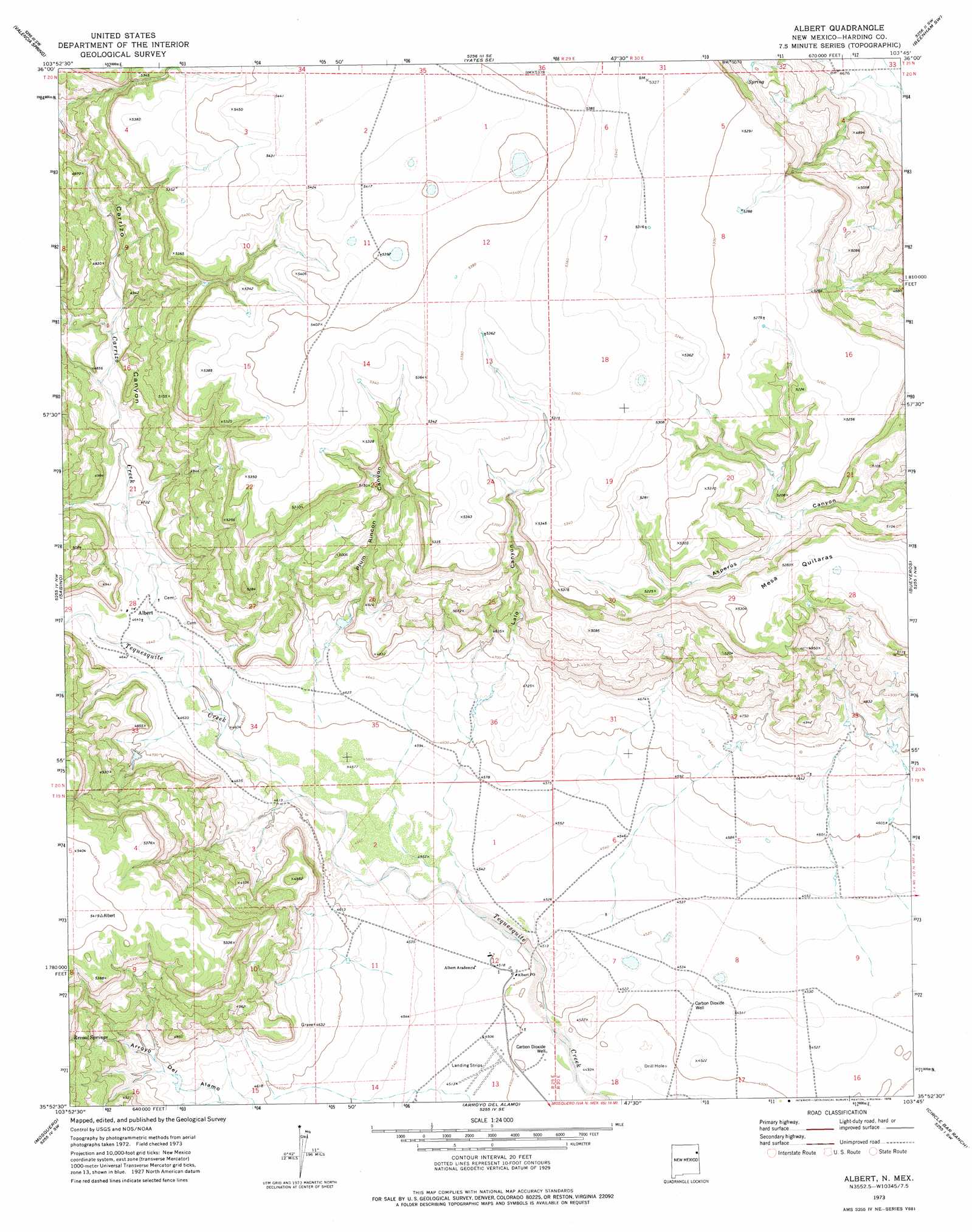
Albert Topo Map New Mexico
To zoom in, hover over the map of Albert
USGS Topo Quad 35103h7 - 1:24,000 scale
| Topo Map Name: | Albert |
| USGS Topo Quad ID: | 35103h7 |
| Print Size: | ca. 21 1/4" wide x 27" high |
| Southeast Coordinates: | 35.875° N latitude / 103.75° W longitude |
| Map Center Coordinates: | 35.9375° N latitude / 103.8125° W longitude |
| U.S. State: | NM |
| Filename: | o35103h7.jpg |
| Download Map JPG Image: | Albert topo map 1:24,000 scale |
| Map Type: | Topographic |
| Topo Series: | 7.5´ |
| Map Scale: | 1:24,000 |
| Source of Map Images: | United States Geological Survey (USGS) |
| Alternate Map Versions: |
Albert NM 1973, updated 1978 Download PDF Buy paper map Albert NM 2010 Download PDF Buy paper map Albert NM 2013 Download PDF Buy paper map Albert NM 2017 Download PDF Buy paper map |
1:24,000 Topo Quads surrounding Albert
Divine Lake |
Yates |
Aragon Hill |
Beenham |
Garcia Creek |
Kansas Valley |
Valencia Spring |
Yates Se |
Beenham Sw |
Minnie Butte |
Kansas Valley Lake |
Sabino |
Albert |
Bueyeros |
Bueyeros Ne |
Solano |
Mosquero |
Arroyo Del Alamo |
Circle Bar Ranch |
Indian Bathtub |
Waggoner Ranch |
Chinaberry Canyon |
Salitre Canyon |
Buffalo Springs |
Gallegos Ne |
> Back to 35103e1 at 1:100,000 scale
> Back to 35102a1 at 1:250,000 scale
> Back to U.S. Topo Maps home
Albert topo map: Gazetteer
Albert: Mines
Amerigas Number Six Mitchell elevation 1378m 4520′Amoco Number One State F C elevation 1632m 5354′
Clay Number One State elevation 1387m 4550′
Albert: Populated Places
Albert elevation 1419m 4655′Albert: Post Offices
Albert Post Office (historical) elevation 1419m 4655′Albert: Streams
Carrizo Creek elevation 1402m 4599′Albert: Summits
Mesa Quitaras elevation 1617m 5305′Albert: Valleys
Carrizo Canyon elevation 1415m 4642′Lalo Canyon elevation 1415m 4642′
Plum Rincon Canyon elevation 1414m 4639′
Tequesquite Canyon elevation 1416m 4645′
Albert digital topo map on disk
Buy this Albert topo map showing relief, roads, GPS coordinates and other geographical features, as a high-resolution digital map file on DVD: