Potrillo Hill Topo Map New Mexico
To zoom in, hover over the map of Potrillo Hill
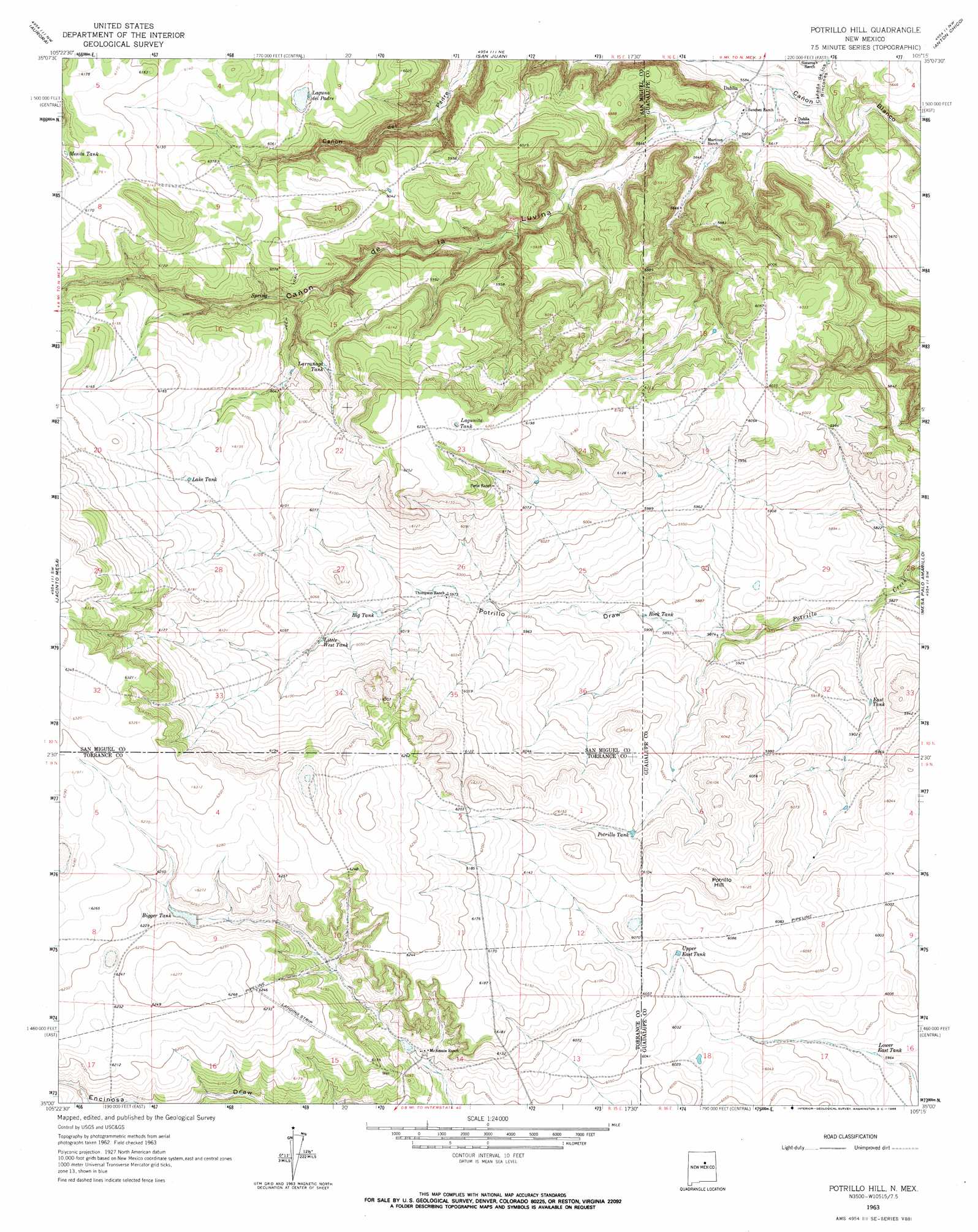
USGS Topo Quad 35105a3 - 1:24,000 scale
| Topo Map Name: | Potrillo Hill |
| USGS Topo Quad ID: | 35105a3 |
| Print Size: | ca. 21 1/4" wide x 27" high |
| Southeast Coordinates: | 35° N latitude / 105.25° W longitude |
| Map Center Coordinates: | 35.0625° N latitude / 105.3125° W longitude |
| U.S. State: | NM |
| Filename: | o35105a3.jpg |
| Download Map JPG Image: | Potrillo Hill topo map 1:24,000 scale |
| Map Type: | Topographic |
| Topo Series: | 7.5´ |
| Map Scale: | 1:24,000 |
| Source of Map Images: | United States Geological Survey (USGS) |
| Alternate Map Versions: |
Potrillo Hill NM 1963, updated 1966 Download PDF Buy paper map Potrillo Hill NM 2010 Download PDF Buy paper map Potrillo Hill NM 2013 Download PDF Buy paper map Potrillo Hill NM 2017 Download PDF Buy paper map |
1:24,000 Topo Quads surrounding Potrillo Hill
Laguna Ortiz |
Sena |
Villanueva |
Apache Springs |
Mesa Chupinas |
Leyba |
Aurora |
San Juan |
Anton Chico |
Dilia |
El Cabo |
Jacinto Mesa |
Potrillo Hill |
Mesa Palo Amarillo |
Thompson Ranch |
Waller Ranch |
Palma |
Milagro Spring |
Milagro |
Pintada |
North Lucy |
Santo Nino Canyon |
Pinavete Canyon |
George Ranch |
Tapia Ranch |
> Back to 35105a1 at 1:100,000 scale
> Back to 35104a1 at 1:250,000 scale
> Back to U.S. Topo Maps home
Potrillo Hill topo map: Gazetteer
Potrillo Hill: Populated Places
Dahlia elevation 1715m 5626′Potrillo Hill: Post Offices
Dahlia Post Office elevation 1715m 5626′Potrillo Hill: Reservoirs
Big Tank elevation 1835m 6020′Bigger Tank elevation 1889m 6197′
East Tank elevation 1793m 5882′
Lake Tank elevation 1872m 6141′
Laquna del Padre elevation 1847m 6059′
Laqunita Tank elevation 1894m 6213′
Larranaga Tank elevation 1840m 6036′
Little West Tank elevation 1847m 6059′
Lower East Tank elevation 1820m 5971′
Potrillo Tank elevation 1846m 6056′
Upper East Tank elevation 1842m 6043′
Potrillo Hill: Streams
Cañada los Rincones elevation 1695m 5561′Potrillo Hill: Summits
Potrillo Hill elevation 1880m 6167′Potrillo Hill: Valleys
Cañon de la Luvina elevation 1713m 5620′Potrillo Draw elevation 1790m 5872′
Potrillo Hill digital topo map on disk
Buy this Potrillo Hill topo map showing relief, roads, GPS coordinates and other geographical features, as a high-resolution digital map file on DVD: