Longhorn Reservoir Topo Map New Mexico
To zoom in, hover over the map of Longhorn Reservoir
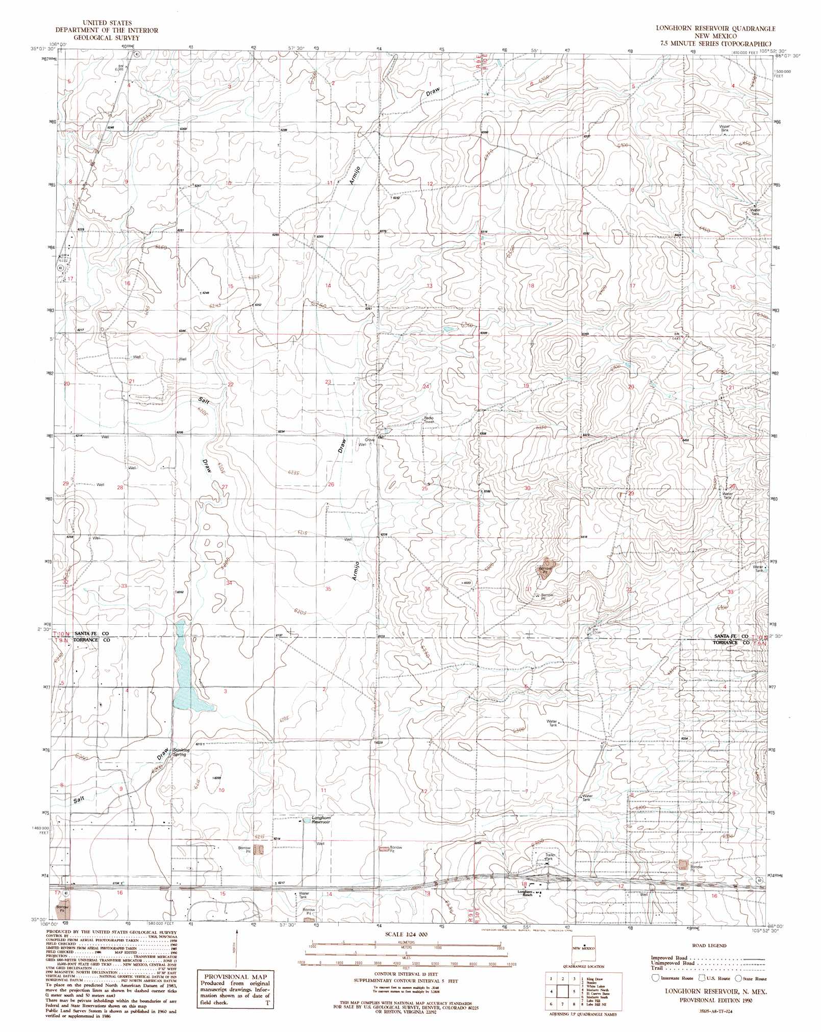
USGS Topo Quad 35105a8 - 1:24,000 scale
| Topo Map Name: | Longhorn Reservoir |
| USGS Topo Quad ID: | 35105a8 |
| Print Size: | ca. 21 1/4" wide x 27" high |
| Southeast Coordinates: | 35° N latitude / 105.875° W longitude |
| Map Center Coordinates: | 35.0625° N latitude / 105.9375° W longitude |
| U.S. State: | NM |
| Filename: | o35105a8.jpg |
| Download Map JPG Image: | Longhorn Reservoir topo map 1:24,000 scale |
| Map Type: | Topographic |
| Topo Series: | 7.5´ |
| Map Scale: | 1:24,000 |
| Source of Map Images: | United States Geological Survey (USGS) |
| Alternate Map Versions: |
Longhorn Reservoir NM 1990, updated 1990 Download PDF Buy paper map Longhorn Reservoir NM 2010 Download PDF Buy paper map Longhorn Reservoir NM 2013 Download PDF Buy paper map Longhorn Reservoir NM 2017 Download PDF Buy paper map |
1:24,000 Topo Quads surrounding Longhorn Reservoir
Golden |
Captain Davis Mountain |
Ojo Hedionda |
Wildhorse Mesa |
Rencona |
San Pedro |
King Draw |
Stanley |
White |
Mesa El Toro |
Edgewood |
Moriarty North |
Longhorn Reservoir |
El Cuervo Butte |
Clines Corners |
Chilili |
Moriarty South |
Lobo Hill |
Lobo Hill Ne |
Rock Lake |
Milbourn Ranch |
Estancia |
Lobo Hill Sw |
Lobo Hill Se |
Pedernal Mountain |
> Back to 35105a1 at 1:100,000 scale
> Back to 35104a1 at 1:250,000 scale
> Back to U.S. Topo Maps home
Longhorn Reservoir topo map: Gazetteer
Longhorn Reservoir: Crossings
Longhorn Ranch Interchange elevation 1929m 6328′Longhorn Reservoir: Parks
Greggs Trail Historical Marker elevation 1929m 6328′Lake Estancia Historical Marker elevation 1929m 6328′
Longhorn Reservoir: Reservoirs
Longhorn Reservoir elevation 1897m 6223′Longhorn Reservoir: Springs
Stinking Spring elevation 1890m 6200′Longhorn Reservoir: Valleys
Armijo Draw elevation 1892m 6207′Longhorn Reservoir: Wells
10016 Water Well elevation 1894m 6213′10018 Water Well elevation 1903m 6243′
101008 Water Well elevation 1902m 6240′
10112 Water Well elevation 1900m 6233′
Longhorn Reservoir digital topo map on disk
Buy this Longhorn Reservoir topo map showing relief, roads, GPS coordinates and other geographical features, as a high-resolution digital map file on DVD: