Las Vegas Topo Map New Mexico
To zoom in, hover over the map of Las Vegas
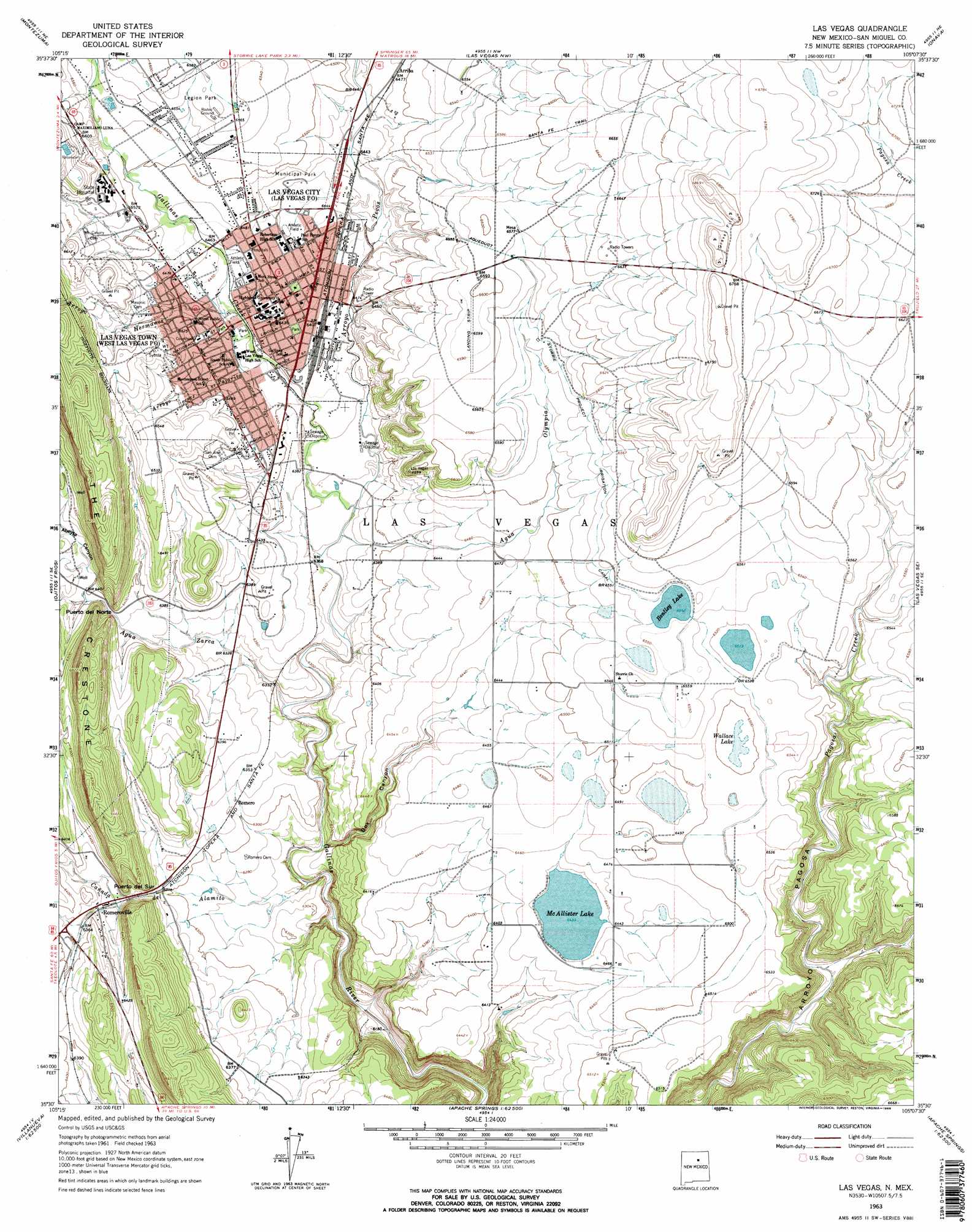
USGS Topo Quad 35105e2 - 1:24,000 scale
| Topo Map Name: | Las Vegas |
| USGS Topo Quad ID: | 35105e2 |
| Print Size: | ca. 21 1/4" wide x 27" high |
| Southeast Coordinates: | 35.5° N latitude / 105.125° W longitude |
| Map Center Coordinates: | 35.5625° N latitude / 105.1875° W longitude |
| U.S. State: | NM |
| Filename: | o35105e2.jpg |
| Download Map JPG Image: | Las Vegas topo map 1:24,000 scale |
| Map Type: | Topographic |
| Topo Series: | 7.5´ |
| Map Scale: | 1:24,000 |
| Source of Map Images: | United States Geological Survey (USGS) |
| Alternate Map Versions: |
Las Vegas NM 1963, updated 1965 Download PDF Buy paper map Las Vegas NM 2010 Download PDF Buy paper map Las Vegas NM 2013 Download PDF Buy paper map Las Vegas NM 2017 Download PDF Buy paper map |
| FStopo: | US Forest Service topo Las Vegas is available: Download FStopo PDF Download FStopo TIF |
1:24,000 Topo Quads surrounding Las Vegas
Rociada |
Sapello |
Lake Isabel |
Loma Parda |
Watrous |
El Porvenir |
Montezuma |
Las Vegas Nw |
Onava |
Goetsch Lake |
San Geronimo |
Ojitos Frios |
Las Vegas |
Las Vegas Se |
Laguna La Monia |
San Jose |
Tecolote |
Los Montoyas |
La Liendre |
Mesa Lauriano |
Sena |
Villanueva |
Apache Springs |
Mesa Chupinas |
Chaperito |
> Back to 35105e1 at 1:100,000 scale
> Back to 35104a1 at 1:250,000 scale
> Back to U.S. Topo Maps home
Las Vegas topo map: Gazetteer
Las Vegas: Canals
Storrie Project Irrigation Canal elevation 2000m 6561′Las Vegas: Gaps
Puerto del Norte elevation 1945m 6381′Puerto del Sur elevation 1933m 6341′
Las Vegas: Lakes
Bentley Lake elevation 1995m 6545′McAllister Lake elevation 1962m 6437′
Wallace Lake elevation 1978m 6489′
Las Vegas: Mines
Marquez Pit elevation 1956m 6417′Las Vegas: Parks
AT and SF RR Depot Locomotive 1129 elevation 1961m 6433′Harold K Brandt Baseball Field elevation 1958m 6423′
Hogbacks Historical Marker elevation 1984m 6509′
Las Vegas Historical Marker elevation 1984m 6509′
Las Vegas National Wildlife Refuge elevation 1979m 6492′
Perkins Stadium elevation 1958m 6423′
Truder Park elevation 1961m 6433′
Las Vegas: Populated Places
Arriba elevation 1978m 6489′East Las Vegas (historical) elevation 1984m 6509′
Las Vegas elevation 1958m 6423′
Romero elevation 1927m 6322′
Romeroville elevation 1939m 6361′
Las Vegas: Post Offices
Las Vegas Post Office elevation 1961m 6433′Old Las Vegas Post Office elevation 1959m 6427′
Romero Post Office (historical) elevation 1927m 6322′
Romeroville Post Office (historical) elevation 1939m 6361′
Las Vegas: Springs
World College Fountain Historic Site elevation 1961m 6433′Las Vegas: Streams
Agua Olympia elevation 1932m 6338′Agua Zarca elevation 1910m 6266′
Arroyo Hermanos elevation 1959m 6427′
Arroyo Pajarito elevation 1952m 6404′
Arroyo Pecos elevation 1933m 6341′
Cañada del Alamito elevation 1886m 6187′
Gallinas Creek elevation 1933m 6341′
Las Vegas: Valleys
Abeyta Canyon elevation 1950m 6397′Box Canyon elevation 1908m 6259′
Las Vegas digital topo map on disk
Buy this Las Vegas topo map showing relief, roads, GPS coordinates and other geographical features, as a high-resolution digital map file on DVD: