Honey Boy Ranch Topo Map New Mexico
To zoom in, hover over the map of Honey Boy Ranch
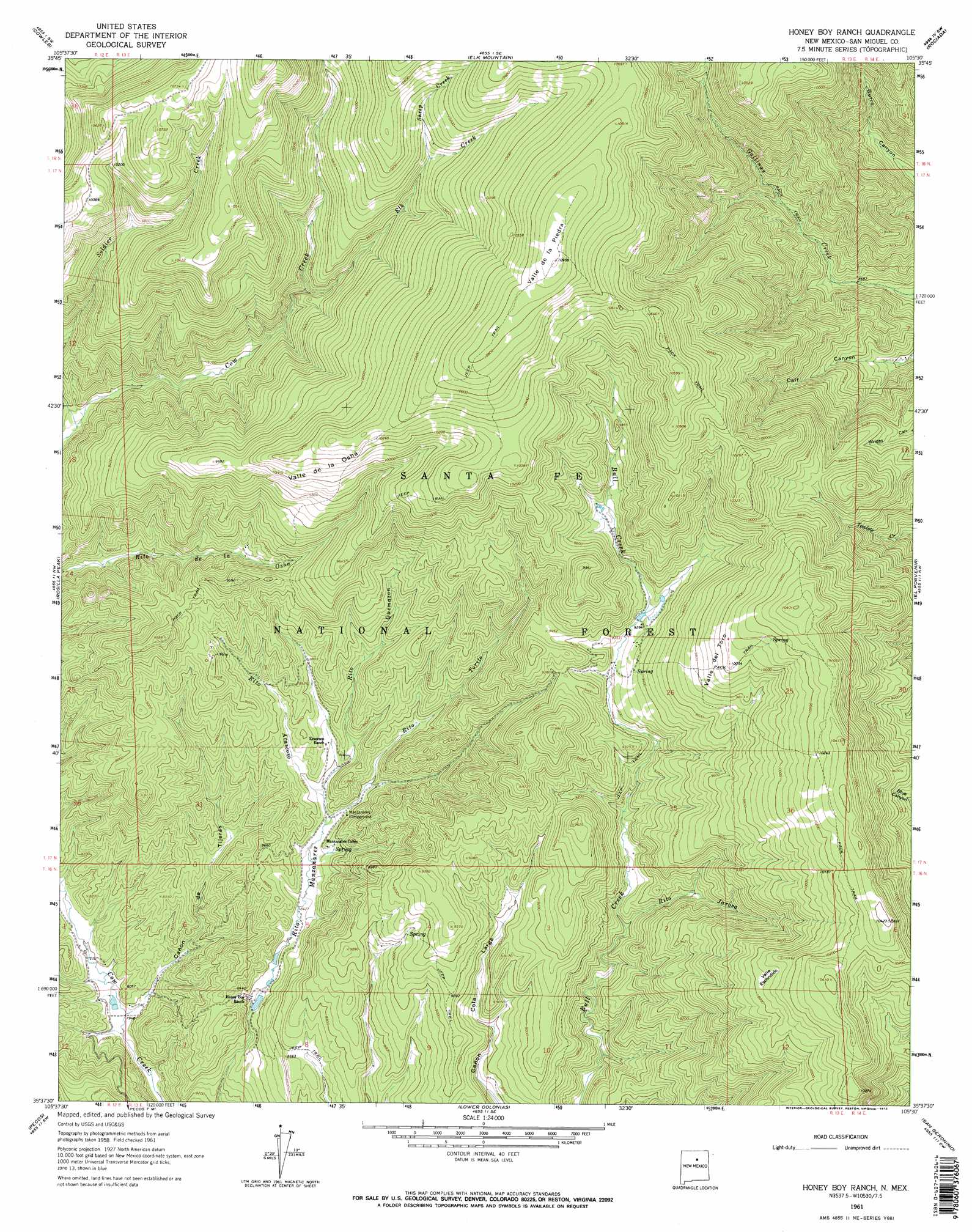
USGS Topo Quad 35105f5 - 1:24,000 scale
| Topo Map Name: | Honey Boy Ranch |
| USGS Topo Quad ID: | 35105f5 |
| Print Size: | ca. 21 1/4" wide x 27" high |
| Southeast Coordinates: | 35.625° N latitude / 105.5° W longitude |
| Map Center Coordinates: | 35.6875° N latitude / 105.5625° W longitude |
| U.S. State: | NM |
| Filename: | o35105f5.jpg |
| Download Map JPG Image: | Honey Boy Ranch topo map 1:24,000 scale |
| Map Type: | Topographic |
| Topo Series: | 7.5´ |
| Map Scale: | 1:24,000 |
| Source of Map Images: | United States Geological Survey (USGS) |
| Alternate Map Versions: |
Honey Boy Ranch NM 1961, updated 1966 Download PDF Buy paper map Honey Boy Ranch NM 1961, updated 1972 Download PDF Buy paper map Honey Boy Ranch NM 1961, updated 1972 Download PDF Buy paper map Honey Boy Ranch NM 2002, updated 2003 Download PDF Buy paper map Honey Boy Ranch NM 2011 Download PDF Buy paper map Honey Boy Ranch NM 2013 Download PDF Buy paper map Honey Boy Ranch NM 2017 Download PDF Buy paper map |
| FStopo: | US Forest Service topo Honey Boy Ranch is available: Download FStopo PDF Download FStopo TIF |
1:24,000 Topo Quads surrounding Honey Boy Ranch
Sierra Mosca |
Truchas Peak |
Pecos Falls |
Gascon |
Mora |
Aspen Basin |
Cowles |
Elk Mountain |
Rociada |
Sapello |
Mcclure Reservoir |
Rosilla Peak |
Honey Boy Ranch |
El Porvenir |
Montezuma |
Glorieta |
Pecos |
Lower Colonias |
San Geronimo |
Ojitos Frios |
Bull Canyon |
Rowe |
North San Ysidro |
San Jose |
Tecolote |
> Back to 35105e1 at 1:100,000 scale
> Back to 35104a1 at 1:250,000 scale
> Back to U.S. Topo Maps home
Honey Boy Ranch topo map: Gazetteer
Honey Boy Ranch: Areas
Valle de la Osha elevation 3089m 10134′Valle de la Piedra elevation 3340m 10958′
Valle del Toro elevation 3032m 9947′
Valle Escondido elevation 3056m 10026′
Honey Boy Ranch: Mines
Faith elevation 2813m 9229′Guy Number One elevation 3060m 10039′
High Peak elevation 2779m 9117′
Honey Boy Ranch: Streams
Elk Creek elevation 2801m 9189′Rito Atascoso elevation 2605m 8546′
Rito de las Quemazones elevation 2675m 8776′
Rito Quemazon elevation 2614m 8576′
Rito Torito elevation 2594m 8510′
Sheep Creek elevation 3010m 9875′
Soldier Creek elevation 2654m 8707′
Honey Boy Ranch: Valleys
Cañon de Tijeras elevation 2419m 7936′Honey Boy Ranch digital topo map on disk
Buy this Honey Boy Ranch topo map showing relief, roads, GPS coordinates and other geographical features, as a high-resolution digital map file on DVD: