Gascon Topo Map New Mexico
To zoom in, hover over the map of Gascon
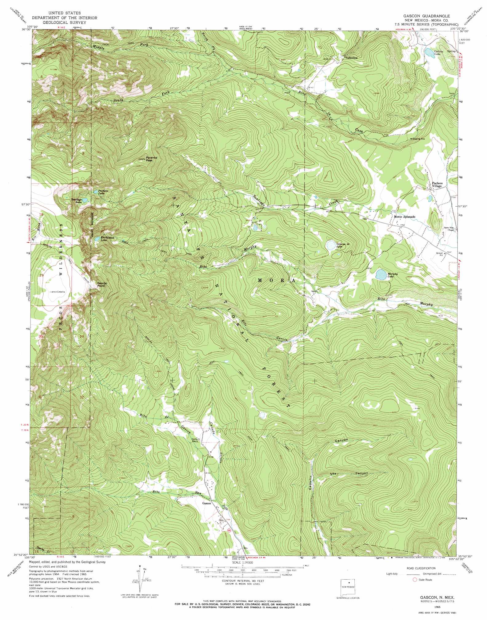
USGS Topo Quad 35105h4 - 1:24,000 scale
| Topo Map Name: | Gascon |
| USGS Topo Quad ID: | 35105h4 |
| Print Size: | ca. 21 1/4" wide x 27" high |
| Southeast Coordinates: | 35.875° N latitude / 105.375° W longitude |
| Map Center Coordinates: | 35.9375° N latitude / 105.4375° W longitude |
| U.S. State: | NM |
| Filename: | o35105h4.jpg |
| Download Map JPG Image: | Gascon topo map 1:24,000 scale |
| Map Type: | Topographic |
| Topo Series: | 7.5´ |
| Map Scale: | 1:24,000 |
| Source of Map Images: | United States Geological Survey (USGS) |
| Alternate Map Versions: |
Gascon NM 1965, updated 1968 Download PDF Buy paper map Gascon NM 1965, updated 1968 Download PDF Buy paper map Gascon NM 2002, updated 2003 Download PDF Buy paper map Gascon NM 2011 Download PDF Buy paper map Gascon NM 2013 Download PDF Buy paper map Gascon NM 2017 Download PDF Buy paper map |
| FStopo: | US Forest Service topo Gascon is available: Download FStopo PDF Download FStopo TIF |
1:24,000 Topo Quads surrounding Gascon
Penasco |
Tres Ritos |
Cerro Vista |
Chacon |
Guadalupita |
El Valle |
Jicarita Peak |
Holman |
Comanche Peak |
Lucero |
Truchas Peak |
Pecos Falls |
Gascon |
Mora |
Rainsville |
Cowles |
Elk Mountain |
Rociada |
Sapello |
Lake Isabel |
Rosilla Peak |
Honey Boy Ranch |
El Porvenir |
Montezuma |
Las Vegas Nw |
> Back to 35105e1 at 1:100,000 scale
> Back to 35104a1 at 1:250,000 scale
> Back to U.S. Topo Maps home
Gascon topo map: Gazetteer
Gascon: Capes
Gascon Point elevation 3574m 11725′Gascon: Dams
Morphy Dam elevation 2397m 7864′Gascon: Lakes
Collins Lake elevation 2287m 7503′Enchanted Lake elevation 3274m 10741′
Laguna de Agua elevation 2557m 8389′
Pacheco Lake elevation 3264m 10708′
Santiago Lake elevation 3312m 10866′
Gascon: Parks
Morphy Lake State Park elevation 2385m 7824′Gascon: Populated Places
Gascon elevation 2454m 8051′Monte Aplanado elevation 2381m 7811′
Pacheco Village elevation 2385m 7824′
Vallecitos elevation 2459m 8067′
Gascon: Post Offices
Gascon Post Office (historical) elevation 2454m 8051′Vallecitos Post Office elevation 2459m 8067′
Gascon: Reservoirs
Morphy Lake elevation 2397m 7864′Gascon: Streams
Cañada Lovato elevation 2447m 8028′Middle Fork Rio de la Casa elevation 2561m 8402′
North Fork Rio la Casa elevation 2517m 8257′
Rito de Gascon elevation 2462m 8077′
Rito Garcia elevation 2351m 7713′
South Fork Rio Casa elevation 2517m 8257′
Gascon: Summits
Pyramid Peak elevation 3227m 10587′Gascon: Trails
Gascon Trail elevation 3315m 10875′Gascon: Valleys
Ute Canyon elevation 2462m 8077′Gascon digital topo map on disk
Buy this Gascon topo map showing relief, roads, GPS coordinates and other geographical features, as a high-resolution digital map file on DVD: