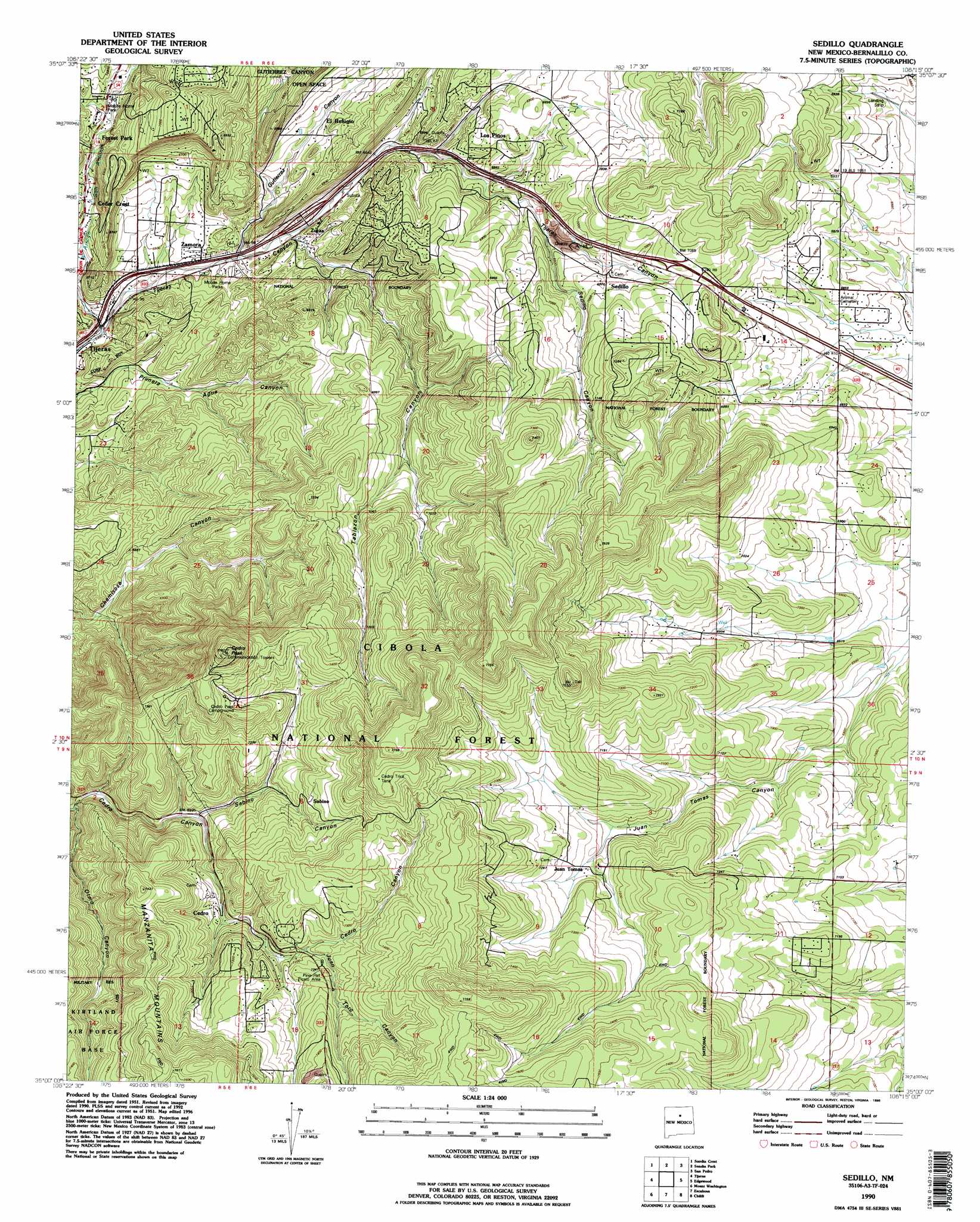
Sedillo Topo Map New Mexico
To zoom in, hover over the map of Sedillo
USGS Topo Quad 35106a3 - 1:24,000 scale
| Topo Map Name: | Sedillo |
| USGS Topo Quad ID: | 35106a3 |
| Print Size: | ca. 21 1/4" wide x 27" high |
| Southeast Coordinates: | 35° N latitude / 106.25° W longitude |
| Map Center Coordinates: | 35.0625° N latitude / 106.3125° W longitude |
| U.S. State: | NM |
| Filename: | o35106a3.jpg |
| Download Map JPG Image: | Sedillo topo map 1:24,000 scale |
| Map Type: | Topographic |
| Topo Series: | 7.5´ |
| Map Scale: | 1:24,000 |
| Source of Map Images: | United States Geological Survey (USGS) |
| Alternate Map Versions: |
Sedillo NM 1954, updated 1955 Download PDF Buy paper map Sedillo NM 1954, updated 1960 Download PDF Buy paper map Sedillo NM 1954, updated 1970 Download PDF Buy paper map Sedillo NM 1954, updated 1986 Download PDF Buy paper map Sedillo NM 1990, updated 1996 Download PDF Buy paper map Sedillo NM 1995, updated 1998 Download PDF Buy paper map Sedillo NM 2011 Download PDF Buy paper map Sedillo NM 2013 Download PDF Buy paper map Sedillo NM 2017 Download PDF Buy paper map |
| FStopo: | US Forest Service topo Sedillo is available: Download FStopo PDF Download FStopo TIF |
1:24,000 Topo Quads surrounding Sedillo
Bernalillo |
Placitas |
Hagan |
Golden |
Captain Davis Mountain |
Alameda |
Sandia Crest |
Sandia Park |
San Pedro |
King Draw |
Albuquerque East |
Tijeras |
Sedillo |
Edgewood |
Moriarty North |
Hubbell Spring |
Mount Washington |
Escabosa |
Chilili |
Moriarty South |
Los Lunas Se |
Bosque Peak |
Tajique |
Milbourn Ranch |
Estancia |
> Back to 35106a1 at 1:100,000 scale
> Back to 35106a1 at 1:250,000 scale
> Back to U.S. Topo Maps home
Sedillo topo map: Gazetteer
Sedillo: Arroyos
Arroyo San Antonio elevation 1951m 6400′Sedillo: Crossings
178-Zuzax Interchange elevation 2002m 6568′Sedillo: Dams
Westgate Detention Dam elevation 2201m 7221′Sedillo: Mines
Hattie Clay Pits elevation 2275m 7463′Holmes Mine elevation 2077m 6814′
Limestone Quarry elevation 2158m 7080′
Mary M. elevation 1994m 6541′
Section One Mine elevation 2114m 6935′
Sedillo: Populated Places
Cedar Crest elevation 2006m 6581′Cedro elevation 2159m 7083′
Comers elevation 2139m 7017′
Dennis Chaves Estates elevation 2106m 6909′
El Refugio elevation 2035m 6676′
El Tablazon elevation 2006m 6581′
Forest Park elevation 2035m 6676′
Juan Tomas elevation 2176m 7139′
Los Pinos elevation 2095m 6873′
Rincon elevation 2031m 6663′
Sedillo elevation 2120m 6955′
Zamora elevation 1993m 6538′
Sedillo: Post Offices
Cedar Crest Post Office elevation 2006m 6581′Los Pinos Post Office elevation 2095m 6873′
Sedillo: Reservoirs
Cedro Trick Tank elevation 2329m 7641′Sedillo: Summits
Cedro Peak elevation 2369m 7772′Sedillo: Valleys
Cañoncito elevation 2056m 6745′Gutierrez Canyon elevation 1982m 6502′
Juan Toro Canyon elevation 2190m 7185′
Otero Canyon elevation 2074m 6804′
Sabino Canyon elevation 2128m 6981′
Sedillo Canyon elevation 2085m 6840′
Tablazon Canyon elevation 1995m 6545′
Sedillo: Wells
100512343 Water Well elevation 1976m 6482′10060 Water Well elevation 1980m 6496′
100605332 Water Well elevation 2032m 6666′
10152 Water Well elevation 2103m 6899′
160 Water Well elevation 1994m 6541′
17 Water Well elevation 1964m 6443′
188 Water Well elevation 2195m 7201′
19 Water Well elevation 1969m 6459′
197 Water Well elevation 2132m 6994′
207 Water Well elevation 2175m 7135′
224 Water Well elevation 2071m 6794′
225 Water Well elevation 2064m 6771′
226 Water Well elevation 2064m 6771′
229 Water Well elevation 2069m 6788′
256 Water Well elevation 2014m 6607′
260 Water Well elevation 2118m 6948′
319 Water Well elevation 2075m 6807′
E-3190 Water Well elevation 2133m 6998′
E-3342 Water Well elevation 2124m 6968′
E-3893 Water Well elevation 2161m 7089′
Junction Water Well elevation 2025m 6643′
RG-22111 Water Well elevation 2166m 7106′
RG-31689 Water Well elevation 2170m 7119′
RG-38914 Water Well elevation 2218m 7276′
RG-39652 Water Well elevation 2181m 7155′
S-137-S Water Well elevation 1994m 6541′
S-184 Water Well elevation 2142m 7027′
S-20 Water Well elevation 2141m 7024′
S-347 Water Well elevation 2049m 6722′
S-373 Water Well elevation 2086m 6843′
S-448 Water Well elevation 2180m 7152′
S-484 Water Well elevation 2064m 6771′
S-488 Water Well elevation 2133m 6998′
S-595 Water Well elevation 2011m 6597′
S-62 Water Well elevation 2025m 6643′
S-635 Water Well elevation 2067m 6781′
S-655 Water Well elevation 1994m 6541′
S-671 Water Well elevation 2091m 6860′
S-697 Water Well elevation 2025m 6643′
S-73 Water Well elevation 1978m 6489′
S-81 Water Well elevation 2080m 6824′
S-82 Water Well elevation 2075m 6807′
S-821 Water Well elevation 2083m 6833′
S-881 Water Well elevation 2101m 6893′
S-886 Water Well elevation 2098m 6883′
S-899 Water Well elevation 2094m 6870′
S-93 Water Well elevation 1978m 6489′
S-959 Water Well elevation 2052m 6732′
Zamora 1 Water Well elevation 1984m 6509′
Sedillo digital topo map on disk
Buy this Sedillo topo map showing relief, roads, GPS coordinates and other geographical features, as a high-resolution digital map file on DVD: