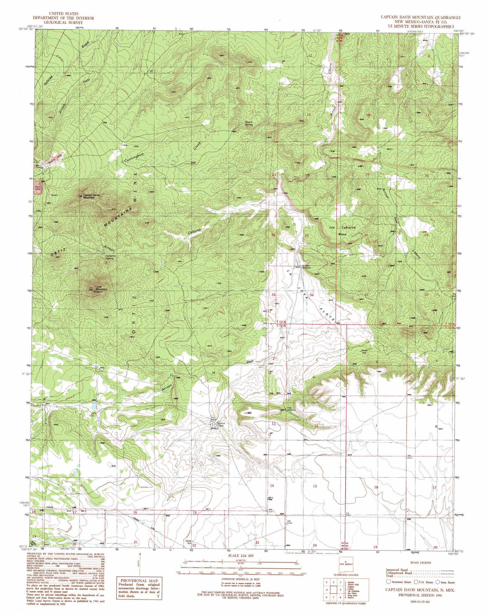
Captain Davis Mountain Topo Map New Mexico
To zoom in, hover over the map of Captain Davis Mountain
USGS Topo Quad 35106c1 - 1:24,000 scale
| Topo Map Name: | Captain Davis Mountain |
| USGS Topo Quad ID: | 35106c1 |
| Print Size: | ca. 21 1/4" wide x 27" high |
| Southeast Coordinates: | 35.25° N latitude / 106° W longitude |
| Map Center Coordinates: | 35.3125° N latitude / 106.0625° W longitude |
| U.S. State: | NM |
| Filename: | o35106c1.jpg |
| Download Map JPG Image: | Captain Davis Mountain topo map 1:24,000 scale |
| Map Type: | Topographic |
| Topo Series: | 7.5´ |
| Map Scale: | 1:24,000 |
| Source of Map Images: | United States Geological Survey (USGS) |
| Alternate Map Versions: |
Captain Davis Mountain NM 1990, updated 1990 Download PDF Buy paper map Captain Davis Mountain NM 2010 Download PDF Buy paper map Captain Davis Mountain NM 2013 Download PDF Buy paper map Captain Davis Mountain NM 2017 Download PDF Buy paper map |
1:24,000 Topo Quads surrounding Captain Davis Mountain
Santo Domingo Pueblo |
Tetilla Peak |
Turquoise Hill |
Seton Village |
Glorieta |
San Felipe Pueblo Ne |
Madrid |
Picture Rock |
Galisteo |
Bull Canyon |
Hagan |
Golden |
Captain Davis Mountain |
Ojo Hedionda |
Wildhorse Mesa |
Sandia Park |
San Pedro |
King Draw |
Stanley |
White |
Sedillo |
Edgewood |
Moriarty North |
Longhorn Reservoir |
El Cuervo Butte |
> Back to 35106a1 at 1:100,000 scale
> Back to 35106a1 at 1:250,000 scale
> Back to U.S. Topo Maps home
Captain Davis Mountain topo map: Gazetteer
Captain Davis Mountain: Flats
La Joya Flats elevation 1911m 6269′Captain Davis Mountain: Mines
Dolores Mine elevation 2070m 6791′Universal elevation 2047m 6715′
Captain Davis Mountain: Populated Places
Dennison Place elevation 2000m 6561′Dolores (historical) elevation 2070m 6791′
Tinen Place elevation 2012m 6601′
Captain Davis Mountain: Post Offices
Dennison Post Office (historical) elevation 2000m 6561′Captain Davis Mountain: Springs
Cañamo Spring elevation 1995m 6545′Peach Spring elevation 1889m 6197′
Captain Davis Mountain: Streams
Arroyo Cañamo elevation 1877m 6158′Arroyo la Joya elevation 1850m 6069′
Arroyo San Lazaro elevation 1850m 6069′
Captain Davis Mountain: Summits
Captain Davis Mountain elevation 2164m 7099′Lone Mountain elevation 2228m 7309′
Los Cobreros Mesa elevation 1968m 6456′
Captain Davis Mountain: Wells
Gage Well elevation 2059m 6755′La Joya Wind Mill Water Well elevation 1897m 6223′
McKee Number 1 Water Well elevation 1808m 5931′
Mine Shack Water Well elevation 2019m 6624′
Number 10 Water Well elevation 1941m 6368′
Number 8 Water Well elevation 1960m 6430′
Number 9 Water Well elevation 1916m 6286′
Pauls Water Well elevation 1928m 6325′
RG-22911 Water Well elevation 2019m 6624′
Captain Davis Mountain digital topo map on disk
Buy this Captain Davis Mountain topo map showing relief, roads, GPS coordinates and other geographical features, as a high-resolution digital map file on DVD: