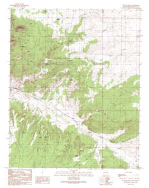
Picture Rock Topo Map New Mexico
To zoom in, hover over the map of Picture Rock
USGS Topo Quad 35106d1 - 1:24,000 scale
| Topo Map Name: | Picture Rock |
| USGS Topo Quad ID: | 35106d1 |
| Print Size: | ca. 21 1/4" wide x 27" high |
| Southeast Coordinates: | 35.375° N latitude / 106° W longitude |
| Map Center Coordinates: | 35.4375° N latitude / 106.0625° W longitude |
| U.S. State: | NM |
| Filename: | o35106d1.jpg |
| Download Map JPG Image: | Picture Rock topo map 1:24,000 scale |
| Map Type: | Topographic |
| Topo Series: | 7.5´ |
| Map Scale: | 1:24,000 |
| Source of Map Images: | United States Geological Survey (USGS) |
| Alternate Map Versions: |
Picture Rock NM 1990, updated 1990 Download PDF Buy paper map Picture Rock NM 2010 Download PDF Buy paper map Picture Rock NM 2013 Download PDF Buy paper map Picture Rock NM 2017 Download PDF Buy paper map |
1:24,000 Topo Quads surrounding Picture Rock
> Back to 35106a1 at 1:100,000 scale
> Back to 35106a1 at 1:250,000 scale
> Back to U.S. Topo Maps home
Picture Rock topo map: Gazetteer
Picture Rock: Arroyos
Gallina Arroyo elevation 1799m 5902′Picture Rock: Cliffs
Garden of the Gods elevation 1810m 5938′Picture Rock: Flats
Poverty Flats elevation 1788m 5866′Picture Rock: Mines
Cash Entry Mine elevation 1877m 6158′Franklin Mine elevation 1879m 6164′
Mina de Terra Mine elevation 1837m 6026′
Mina Del Tiro elevation 1833m 6013′
Turquoise Mines elevation 1856m 6089′
Yellow Pearl Placer elevation 1774m 5820′
Picture Rock: Parks
Garden of the Gods Historical Marker elevation 1810m 5938′Picture Rock: Populated Places
Cerrillos elevation 1745m 5725′Los Cerrilos elevation 1735m 5692′
Picture Rock: Reservoirs
Cerrillos Reservoir elevation 1797m 5895′Finger Lake elevation 1788m 5866′
Picture Rock: Springs
Cottonwood Spring elevation 1813m 5948′Coyote Spring elevation 1830m 6003′
Coyote Spring elevation 1842m 6043′
Hillside Spring elevation 1824m 5984′
Oak Spring elevation 1849m 6066′
San Marcos Spring elevation 1836m 6023′
Picture Rock: Streams
Arroyo Chorro elevation 1781m 5843′Arroyo Coyote elevation 1842m 6043′
Arroyo de la Vaca elevation 1764m 5787′
Arroyo Jara elevation 1791m 5875′
Arroyo Viejo elevation 1748m 5734′
Cañada de la Cueva elevation 1769m 5803′
Cunningham Creek elevation 1787m 5862′
San Marcos Arroyo elevation 1735m 5692′
Picture Rock: Summits
El Cerro della Cosena elevation 2053m 6735′Mount Chalchihuitl elevation 1886m 6187′
Picture Rock elevation 1878m 6161′
Picture Rock: Valleys
Dolores Gulch elevation 1762m 5780′Picture Rock: Wells
10209 Water Well elevation 1866m 6122′E 85-S5 Water Well elevation 1876m 6154′
Harris Water Well elevation 1860m 6102′
Movie Ranch Water Well elevation 1844m 6049′
New Wind Mill Water Well elevation 1777m 5830′
Old Delres Water Well elevation 1792m 5879′
RG-13214 Water Well elevation 1894m 6213′
RG-15702 Water Well elevation 1885m 6184′
RG-18333 Water Well elevation 1878m 6161′
RG-18380 Water Well elevation 1872m 6141′
RG-19106 Water Well elevation 1763m 5784′
RG-19106 Water Well elevation 1764m 5787′
RG-19252 Water Well elevation 1878m 6161′
RG-19831 Water Well elevation 1788m 5866′
RG-20177 Water Well elevation 1768m 5800′
RG-22186 Water Well elevation 1883m 6177′
RG-22752 Water Well elevation 1897m 6223′
RG-22840 Water Well elevation 1871m 6138′
RG-22915 Water Well elevation 1831m 6007′
RG-24423 Water Well elevation 1760m 5774′
RG-24629X5 Water Well elevation 1812m 5944′
RG-24629X6 Water Well elevation 1859m 6099′
RG-24629X7 Water Well elevation 1867m 6125′
RG-24629X8 Water Well elevation 1878m 6161′
RG-24749 WAter Well elevation 1860m 6102′
RG-25247 Water Well elevation 1824m 5984′
RG-26046 Water Well elevation 1848m 6062′
RG-26341 Water Well elevation 1898m 6227′
RG-26502-X Water Well elevation 1760m 5774′
RG-26994 Water Well elevation 1858m 6095′
RG-27187 Water Well elevation 1865m 6118′
RG-27604 Water Well elevation 1829m 6000′
RG-27617 Water Well elevation 1849m 6066′
RG-27758 Water Well elevation 1876m 6154′
RG-27923 Water Well elevation 1836m 6023′
RG-27923 Water Well elevation 1830m 6003′
RG-28132 Water Well elevation 1767m 5797′
RG-28290 Water Well elevation 1784m 5853′
RG-28347 Water Well elevation 1864m 6115′
RG-28436 Water Well elevation 1780m 5839′
RG-28715 Water Well elevation 1879m 6164′
RG-29041 Water Well elevation 1884m 6181′
RG-29082 Water Well elevation 1869m 6131′
RG-29103-1 Water Well elevation 1845m 6053′
RG-29103-2 Water Well elevation 1868m 6128′
RG-29103-3 Water Well elevation 1872m 6141′
RG-29104 Water Well elevation 1858m 6095′
RG-29432 Water Well elevation 1842m 6043′
RG-29998 Water Well elevation 1736m 5695′
RG-30318 Water Well elevation 1843m 6046′
RG-30382 Water Well elevation 1923m 6309′
RG-30690 Water Well elevation 1919m 6295′
RG-31004 Water Well elevation 1860m 6102′
RG-31417 Water Well elevation 1788m 5866′
RG-32087 Water Well elevation 1873m 6145′
RG-32513 Water Well elevation 1830m 6003′
RG-8989 Water Well elevation 1862m 6108′
RGT-30172 Water Well elevation 1738m 5702′
Test 3 Water Well elevation 1845m 6053′
Picture Rock digital topo map on disk
Buy this Picture Rock topo map showing relief, roads, GPS coordinates and other geographical features, as a high-resolution digital map file on DVD:


