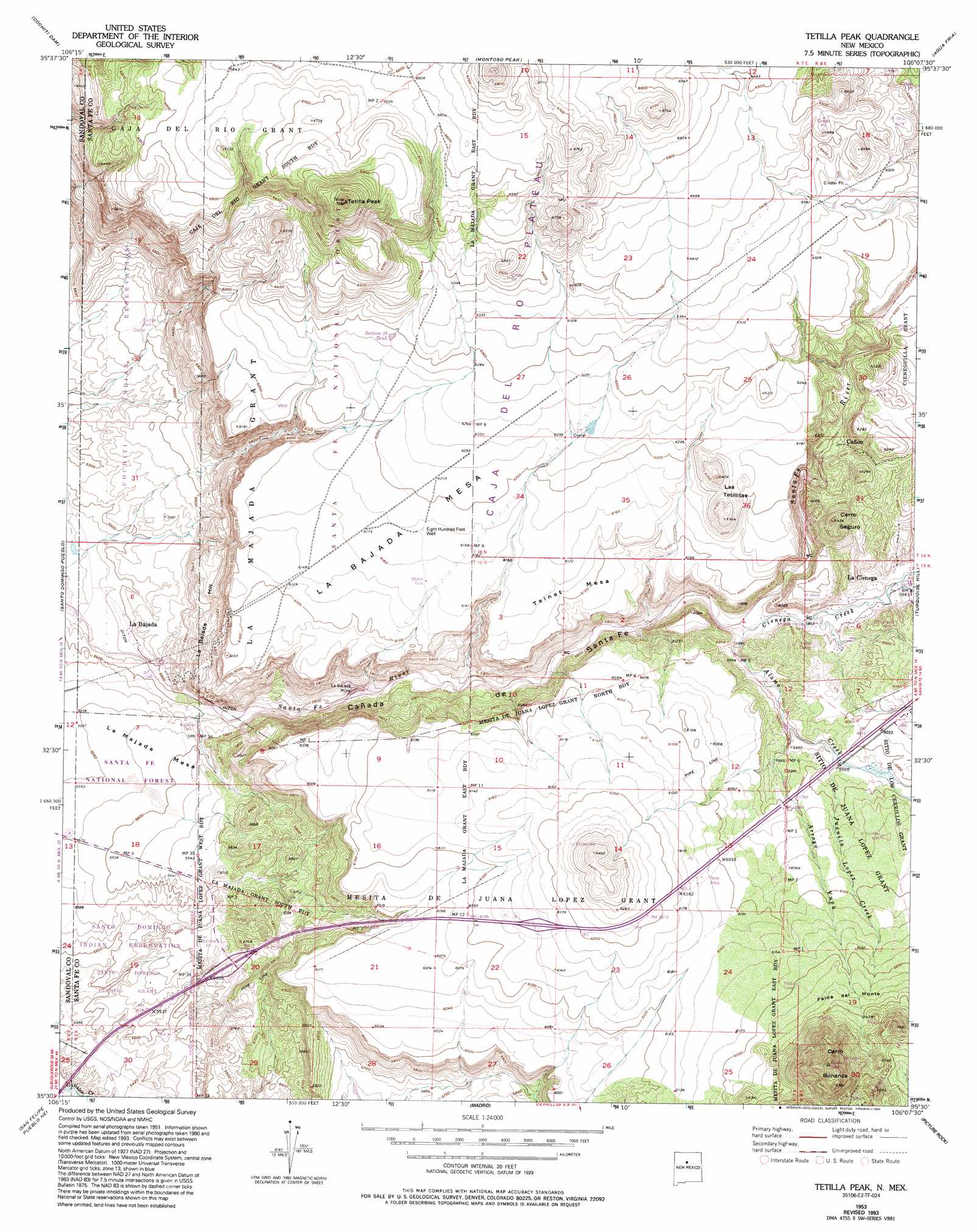
Tetilla Peak Topo Map New Mexico
To zoom in, hover over the map of Tetilla Peak
USGS Topo Quad 35106e2 - 1:24,000 scale
| Topo Map Name: | Tetilla Peak |
| USGS Topo Quad ID: | 35106e2 |
| Print Size: | ca. 21 1/4" wide x 27" high |
| Southeast Coordinates: | 35.5° N latitude / 106.125° W longitude |
| Map Center Coordinates: | 35.5625° N latitude / 106.1875° W longitude |
| U.S. State: | NM |
| Filename: | o35106e2.jpg |
| Download Map JPG Image: | Tetilla Peak topo map 1:24,000 scale |
| Map Type: | Topographic |
| Topo Series: | 7.5´ |
| Map Scale: | 1:24,000 |
| Source of Map Images: | United States Geological Survey (USGS) |
| Alternate Map Versions: |
Tetilla Peak NM 1953, updated 1954 Download PDF Buy paper map Tetilla Peak NM 1953, updated 1963 Download PDF Buy paper map Tetilla Peak NM 1953, updated 1974 Download PDF Buy paper map Tetilla Peak NM 1953, updated 1978 Download PDF Buy paper map Tetilla Peak NM 1953, updated 1993 Download PDF Buy paper map Tetilla Peak NM 2002, updated 2003 Download PDF Buy paper map Tetilla Peak NM 2011 Download PDF Buy paper map Tetilla Peak NM 2013 Download PDF Buy paper map Tetilla Peak NM 2017 Download PDF Buy paper map |
| FStopo: | US Forest Service topo Tetilla Peak is available: Download FStopo PDF Download FStopo TIF |
1:24,000 Topo Quads surrounding Tetilla Peak
Bland |
Frijoles |
White Rock |
Horcado Ranch |
Tesuque |
Canada |
Cochiti Dam |
Montoso Peak |
Agua Fria |
Santa Fe |
Santo Domingo Pueblo Sw |
Santo Domingo Pueblo |
Tetilla Peak |
Turquoise Hill |
Seton Village |
San Felipe Pueblo |
San Felipe Pueblo Ne |
Madrid |
Picture Rock |
Galisteo |
Placitas |
Hagan |
Golden |
Captain Davis Mountain |
Ojo Hedionda |
> Back to 35106e1 at 1:100,000 scale
> Back to 35106a1 at 1:250,000 scale
> Back to U.S. Topo Maps home
Tetilla Peak topo map: Gazetteer
Tetilla Peak: Arroyos
Arroyo Yupa elevation 1796m 5892′Tetilla Peak: Benches
La Bajada Mesa elevation 1885m 6184′Tsinat Mesa elevation 1866m 6122′
Tetilla Peak: Crossings
267 Waldo Interchange elevation 1873m 6145′La Bajada Interchange elevation 1726m 5662′
Tetilla Peak: Mines
Evelyn Mine elevation 1935m 6348′Hiser-Moore Claims elevation 1793m 5882′
La Bajada Mine elevation 1707m 5600′
La Cienega elevation 1860m 6102′
La Cieniga Scoria elevation 1929m 6328′
La Majada elevation 1774m 5820′
Lone Star Mine elevation 1707m 5600′
Trio Claim elevation 1929m 6328′
Tetilla Peak: Parks
Gold and Turquoise Historical Marker elevation 1885m 6184′La Bajada Historical Marker elevation 1885m 6184′
La Bajada Historical Marker elevation 1747m 5731′
South End of the Rockies Historical Marker elevation 1885m 6184′
Tetilla Peak: Populated Places
La Bajada elevation 1677m 5501′La Cienega elevation 1808m 5931′
Tetilla Peak: Post Offices
La Bajada Post Office (historical) elevation 1677m 5501′La Cienega Post Office (historical) elevation 1808m 5931′
Tetilla Peak: Reservoirs
Cochiti Well elevation 1713m 5620′Rim Well elevation 1892m 6207′
Section 28 Tank elevation 1917m 6289′
Section Twenty-Eight Tank elevation 1917m 6289′
Tetilla Trick Tant elevation 1890m 6200′
Tetilla Peak: Slopes
Falda del Monte elevation 1905m 6250′La Bajada Hill elevation 1747m 5731′
Tetilla Peak: Streams
Alamo Creek elevation 1775m 5823′Cienega Creek elevation 1779m 5836′
Juanita Lopez Creek elevation 1805m 5921′
Tetilla Peak: Summits
Cerro Bonanza elevation 2148m 7047′Cerro Seguro elevation 1957m 6420′
Las Tetillitas elevation 1955m 6414′
Tetilla Peak elevation 2183m 7162′
Tetilla Peak: Valleys
Cañada de Santa Fe elevation 1676m 5498′Tetilla Peak: Wells
10095 Water Well elevation 1854m 6082′Cochiti Well elevation 1711m 5613′
Eight Hundred Foot Well elevation 1883m 6177′
RG-13743 Water Well elevation 1808m 5931′
RG-16860 Water Well elevation 1794m 5885′
RG-18706 Water Well elevation 1865m 6118′
RG-22606 Water Well elevation 1800m 5905′
RG-22771 Water Well elevation 1895m 6217′
RG-23362 Water Well elevation 1820m 5971′
RG-24679 Water Well elevation 1820m 5971′
RG-30067 Water Well elevation 1967m 6453′
RG-3869 Water Well elevation 1820m 5971′
RG-4050 Water Well elevation 1801m 5908′
RG-7308 Water Well elevation 1824m 5984′
RG-7373 Water Well elevation 1863m 6112′
RG-8247 Water Well elevation 1820m 5971′
Thompson 1 Water Well elevation 1812m 5944′
Tetilla Peak digital topo map on disk
Buy this Tetilla Peak topo map showing relief, roads, GPS coordinates and other geographical features, as a high-resolution digital map file on DVD: