Valle San Antonio Topo Map New Mexico
To zoom in, hover over the map of Valle San Antonio
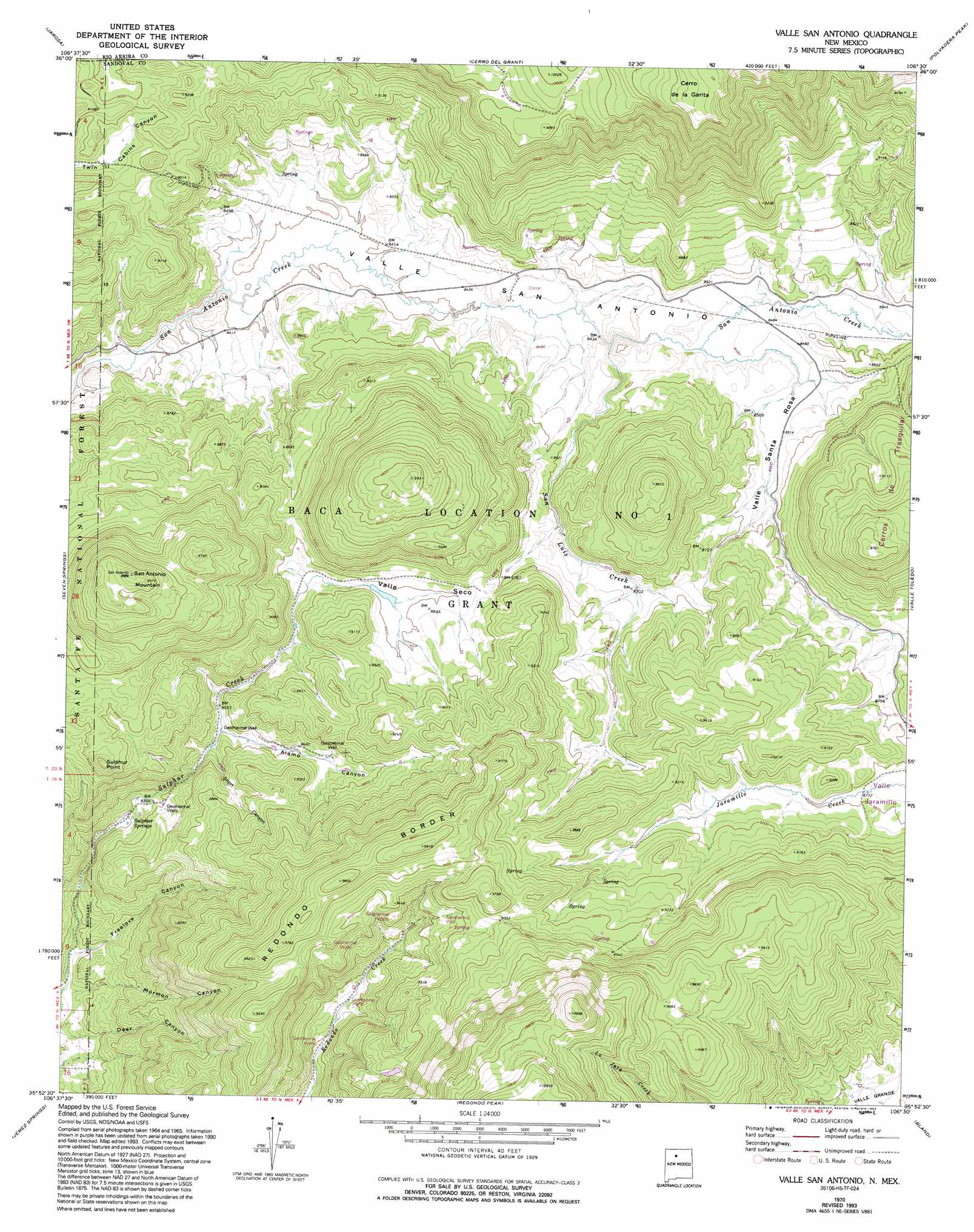
USGS Topo Quad 35106h5 - 1:24,000 scale
| Topo Map Name: | Valle San Antonio |
| USGS Topo Quad ID: | 35106h5 |
| Print Size: | ca. 21 1/4" wide x 27" high |
| Southeast Coordinates: | 35.875° N latitude / 106.5° W longitude |
| Map Center Coordinates: | 35.9375° N latitude / 106.5625° W longitude |
| U.S. State: | NM |
| Filename: | o35106h5.jpg |
| Download Map JPG Image: | Valle San Antonio topo map 1:24,000 scale |
| Map Type: | Topographic |
| Topo Series: | 7.5´ |
| Map Scale: | 1:24,000 |
| Source of Map Images: | United States Geological Survey (USGS) |
| Alternate Map Versions: |
Valle San Antonio NM 1970, updated 1973 Download PDF Buy paper map Valle San Antonio NM 1970, updated 1978 Download PDF Buy paper map Valle San Antonio NM 1970, updated 1993 Download PDF Buy paper map Valle San Antonio NM 2002, updated 2003 Download PDF Buy paper map Valle San Antonio NM 2011 Download PDF Buy paper map Valle San Antonio NM 2013 Download PDF Buy paper map Valle San Antonio NM 2017 Download PDF Buy paper map |
| FStopo: | US Forest Service topo Valle San Antonio is available: Download FStopo PDF Download FStopo TIF |
1:24,000 Topo Quads surrounding Valle San Antonio
Gallina |
Arroyo Del Agua |
Youngsville |
Canones |
Abiquiu |
Nacimiento Peak |
Jarosa |
Cerro Del Grant |
Polvadera Peak |
Vallecitos |
Rancho Del Chaparral |
Seven Springs |
Valle San Antonio |
Valle Toledo |
Guaje Mountain |
San Miguel Mountain |
Jemez Springs |
Redondo Peak |
Bland |
Frijoles |
Gilman |
Ponderosa |
Bear Springs Peak |
Canada |
Cochiti Dam |
> Back to 35106e1 at 1:100,000 scale
> Back to 35106a1 at 1:250,000 scale
> Back to U.S. Topo Maps home
Valle San Antonio topo map: Gazetteer
Valle San Antonio: Craters
Valles Caldera elevation 2860m 9383′Valle San Antonio: Mines
Steam Well Mine elevation 2837m 9307′Steam Well Mine elevation 2585m 8480′
Steam Well Mine elevation 2658m 8720′
Sulphur Bank Group elevation 2507m 8225′
Sulphur Springs elevation 2540m 8333′
Valle San Antonio: Parks
Valles Caldera National Preserve elevation 2722m 8930′Valle San Antonio: Populated Places
Sulphur Springs elevation 2500m 8202′Valle San Antonio: Post Offices
Sulphur Springs Post Office (historical) elevation 2500m 8202′Valle San Antonio: Ridges
Redondo Border elevation 3006m 9862′Valle San Antonio: Springs
Electric Spring elevation 2499m 8198′Footbath Spring elevation 2501m 8205′
Kidney and Stomach Trouble Spring elevation 2499m 8198′
Ladies Bath House elevation 2522m 8274′
Laxitive Spring elevation 2491m 8172′
Lemonade Spring elevation 2501m 8205′
Mens Bath House elevation 2517m 8257′
San Antonio Warm Spring elevation 2578m 8458′
Sulphur Springs elevation 2496m 8188′
Turkey Spring elevation 2604m 8543′
Valle San Antonio: Streams
San Luis Creek elevation 2573m 8441′Valle San Antonio: Summits
Cerro de la Garita elevation 3225m 10580′Cerros de Trasquilar elevation 2953m 9688′
San Antonio Mountain elevation 3041m 9977′
Sulphur Point elevation 2825m 9268′
Valle San Antonio: Valleys
Alamo Canyon elevation 2585m 8480′Freelove Canyon elevation 2410m 7906′
Mormon Canyon elevation 2400m 7874′
Short Canyon elevation 2587m 8487′
Valle San Antonio elevation 2544m 8346′
Valle Santa Rosa elevation 2582m 8471′
Valle Seco elevation 2652m 8700′
Valle San Antonio digital topo map on disk
Buy this Valle San Antonio topo map showing relief, roads, GPS coordinates and other geographical features, as a high-resolution digital map file on DVD: