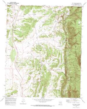
San Pablo Topo Map New Mexico
To zoom in, hover over the map of San Pablo
USGS Topo Quad 35106h8 - 1:24,000 scale
| Topo Map Name: | San Pablo |
| USGS Topo Quad ID: | 35106h8 |
| Print Size: | ca. 21 1/4" wide x 27" high |
| Southeast Coordinates: | 35.875° N latitude / 106.875° W longitude |
| Map Center Coordinates: | 35.9375° N latitude / 106.9375° W longitude |
| U.S. State: | NM |
| Filename: | o35106h8.jpg |
| Download Map JPG Image: | San Pablo topo map 1:24,000 scale |
| Map Type: | Topographic |
| Topo Series: | 7.5´ |
| Map Scale: | 1:24,000 |
| Source of Map Images: | United States Geological Survey (USGS) |
| Alternate Map Versions: |
San Pablo NM 1970, updated 1973 Download PDF Buy paper map San Pablo NM 2002, updated 2003 Download PDF Buy paper map San Pablo NM 2011 Download PDF Buy paper map San Pablo NM 2013 Download PDF Buy paper map San Pablo NM 2017 Download PDF Buy paper map |
| FStopo: | US Forest Service topo San Pablo is available: Download FStopo PDF Download FStopo TIF |
1:24,000 Topo Quads surrounding San Pablo
> Back to 35106e1 at 1:100,000 scale
> Back to 35106a1 at 1:250,000 scale
> Back to U.S. Topo Maps home
San Pablo topo map: Gazetteer
San Pablo: Mines
Alpha Humas Pit elevation 2196m 7204′Black Rose Prospect elevation 2103m 6899′
Dennison - Bunn Prospect elevation 2337m 7667′
Don Number 11 elevation 2427m 7962′
Mauldian Prospect elevation 2214m 7263′
McDonald and Kissler Prospect elevation 2114m 6935′
Nacimiento Copper Mine elevation 2316m 7598′
Nacimiento Mine elevation 2277m 7470′
Padilla Mine elevation 2107m 6912′
San Miguel - Padilla Mine elevation 2106m 6909′
San Miguel Mine elevation 2109m 6919′
San Ysidro Number One Humos Pit elevation 2069m 6788′
Senorita Mine elevation 2169m 7116′
Warm Springs Mine elevation 2109m 6919′
San Pablo: Populated Places
Lagunitas elevation 2082m 6830′San Miguel elevation 2159m 7083′
San Pablo elevation 2160m 7086′
Señorito elevation 2172m 7125′
San Pablo: Post Offices
Señorito Post Office (historical) elevation 2172m 7125′San Pablo: Ridges
Cerro Castrado elevation 2691m 8828′San Pablo: Springs
Horseshoe Spring elevation 2396m 7860′San Miguel Spring elevation 2228m 7309′
San Pablo: Streams
Arroyo Chijuilla elevation 2042m 6699′Arroyo Hondo elevation 2053m 6735′
San Pablo: Summits
Marion Butte elevation 2085m 6840′San Pablo: Valleys
La Guzpa Canyon elevation 2012m 6601′San Miguel Canyon elevation 2042m 6699′
San Miguelito Canyon elevation 2190m 7185′
San Pablo Canyon elevation 2031m 6663′
Señorito Canyon elevation 2053m 6735′
San Pablo: Wells
Brandy 2 Water Well elevation 2066m 6778′San Pablo digital topo map on disk
Buy this San Pablo topo map showing relief, roads, GPS coordinates and other geographical features, as a high-resolution digital map file on DVD:


