San Rafael Topo Map New Mexico
To zoom in, hover over the map of San Rafael
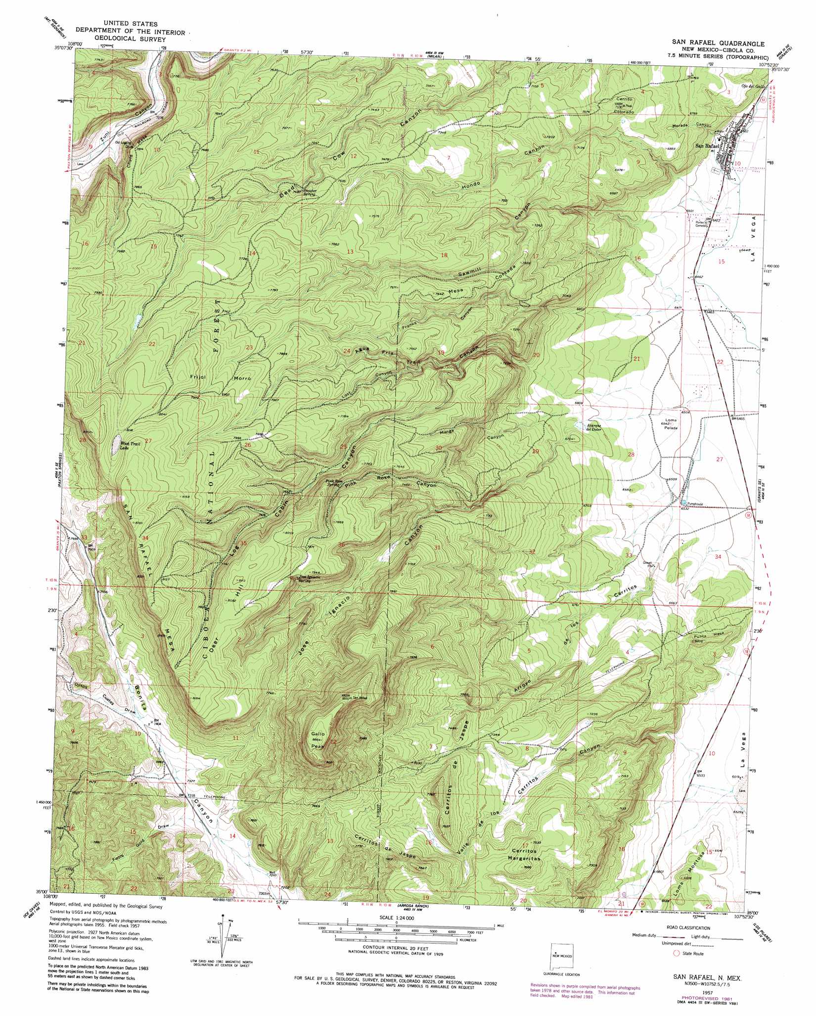
USGS Topo Quad 35107a8 - 1:24,000 scale
| Topo Map Name: | San Rafael |
| USGS Topo Quad ID: | 35107a8 |
| Print Size: | ca. 21 1/4" wide x 27" high |
| Southeast Coordinates: | 35° N latitude / 107.875° W longitude |
| Map Center Coordinates: | 35.0625° N latitude / 107.9375° W longitude |
| U.S. State: | NM |
| Filename: | o35107a8.jpg |
| Download Map JPG Image: | San Rafael topo map 1:24,000 scale |
| Map Type: | Topographic |
| Topo Series: | 7.5´ |
| Map Scale: | 1:24,000 |
| Source of Map Images: | United States Geological Survey (USGS) |
| Alternate Map Versions: |
San Rafael NM 1957, updated 1959 Download PDF Buy paper map San Rafael NM 1957, updated 1981 Download PDF Buy paper map San Rafael NM 1995, updated 1998 Download PDF Buy paper map San Rafael NM 2011 Download PDF Buy paper map San Rafael NM 2013 Download PDF Buy paper map |
| FStopo: | US Forest Service topo San Rafael is available: Download FStopo PDF Download FStopo TIF |
1:24,000 Topo Quads surrounding San Rafael
Pine Canyon |
Prewitt |
Bluewater |
Dos Lomas |
San Mateo |
Post Office Flat |
Mount Sedgwick |
Milan |
Grants |
Lobo Springs |
Valle Largo |
Paxton Springs |
San Rafael |
Grants Se |
Mccartys |
Cerro Hueco |
Ice Caves |
Arrosa Ranch |
Los Pilares |
Crow Point |
Cerro Brilliante |
Ice Caves Se |
North Pasture |
Laguna Honda |
Blue Mesa |
> Back to 35107a1 at 1:100,000 scale
> Back to 35106a1 at 1:250,000 scale
> Back to U.S. Topo Maps home
San Rafael topo map: Gazetteer
San Rafael: Areas
Frijol Morro elevation 2405m 7890′San Rafael: Lakes
West Trail Lake elevation 2475m 8120′San Rafael: Mines
Boneekay Mine elevation 2373m 7785′Cibola elevation 2251m 7385′
Cooperation District Mine elevation 2421m 7942′
Copper Hill District Mine elevation 2421m 7942′
Hanosh Mine elevation 2421m 7942′
Irene Number Two Mine elevation 2282m 7486′
Low Lease Mine elevation 2421m 7942′
Mathew - Whiteside Mine elevation 2421m 7942′
Miable Mine elevation 2421m 7942′
Montezuma District Mine elevation 2421m 7942′
Section 15 Prospect elevation 2282m 7486′
San Rafael: Parks
San Rafael Historical Marker elevation 1972m 6469′San Rafael: Populated Places
San Rafael elevation 1972m 6469′San Rafael: Post Offices
San Rafael Post Office elevation 1972m 6469′San Rafael: Reservoirs
Atarque del Doter elevation 2019m 6624′San Rafael: Ridges
Chute Mesa elevation 2381m 7811′Punta Mesa elevation 2059m 6755′
San Rafael: Springs
Jose Ignacio Spring elevation 2389m 7837′Ojo del Gallo elevation 1970m 6463′
Ojo del Gallo elevation 1969m 6459′
Pink Rose Spring elevation 2312m 7585′
Snooter Spring elevation 2285m 7496′
San Rafael: Summits
Cerrito Colorado elevation 2159m 7083′Cerritos Margaritas elevation 2307m 7568′
Deer Hill elevation 2495m 8185′
Gallo Peak elevation 2642m 8667′
Loma Montosa elevation 2049m 6722′
Loma Pelada elevation 1995m 6545′
Mesa Cortada elevation 2232m 7322′
Punta Mesa elevation 2077m 6814′
San Rafael Mesa elevation 2533m 8310′
San Rafael: Valleys
Agua Fria Trail Canyon elevation 2061m 6761′Arroyo de los Cerritos elevation 1980m 6496′
Fools Gold Draw elevation 2218m 7276′
Franks Canyon elevation 2034m 6673′
Hondo Canyon elevation 1987m 6519′
Jose Ignacio Canyon elevation 2023m 6637′
Log Cabin Canyon elevation 2160m 7086′
Lost Canyon elevation 2223m 7293′
Manga Canyon elevation 2060m 6758′
Morada Canyon elevation 1979m 6492′
Ojitos Cuates Draw elevation 2259m 7411′
Pink Rose Canyon elevation 2169m 7116′
Sawmill Canyon elevation 2000m 6561′
Valle de los Cerritos elevation 2008m 6587′
San Rafael: Wells
10021 Water Well elevation 1988m 6522′10036 Water Well elevation 1974m 6476′
10037 Water Well elevation 1970m 6463′
10038 Water Well elevation 1970m 6463′
10039 Water Well elevation 1968m 6456′
10043 Water Well elevation 1990m 6528′
Slide Water Well elevation 2342m 7683′
San Rafael digital topo map on disk
Buy this San Rafael topo map showing relief, roads, GPS coordinates and other geographical features, as a high-resolution digital map file on DVD: