Hospah Topo Map New Mexico
To zoom in, hover over the map of Hospah
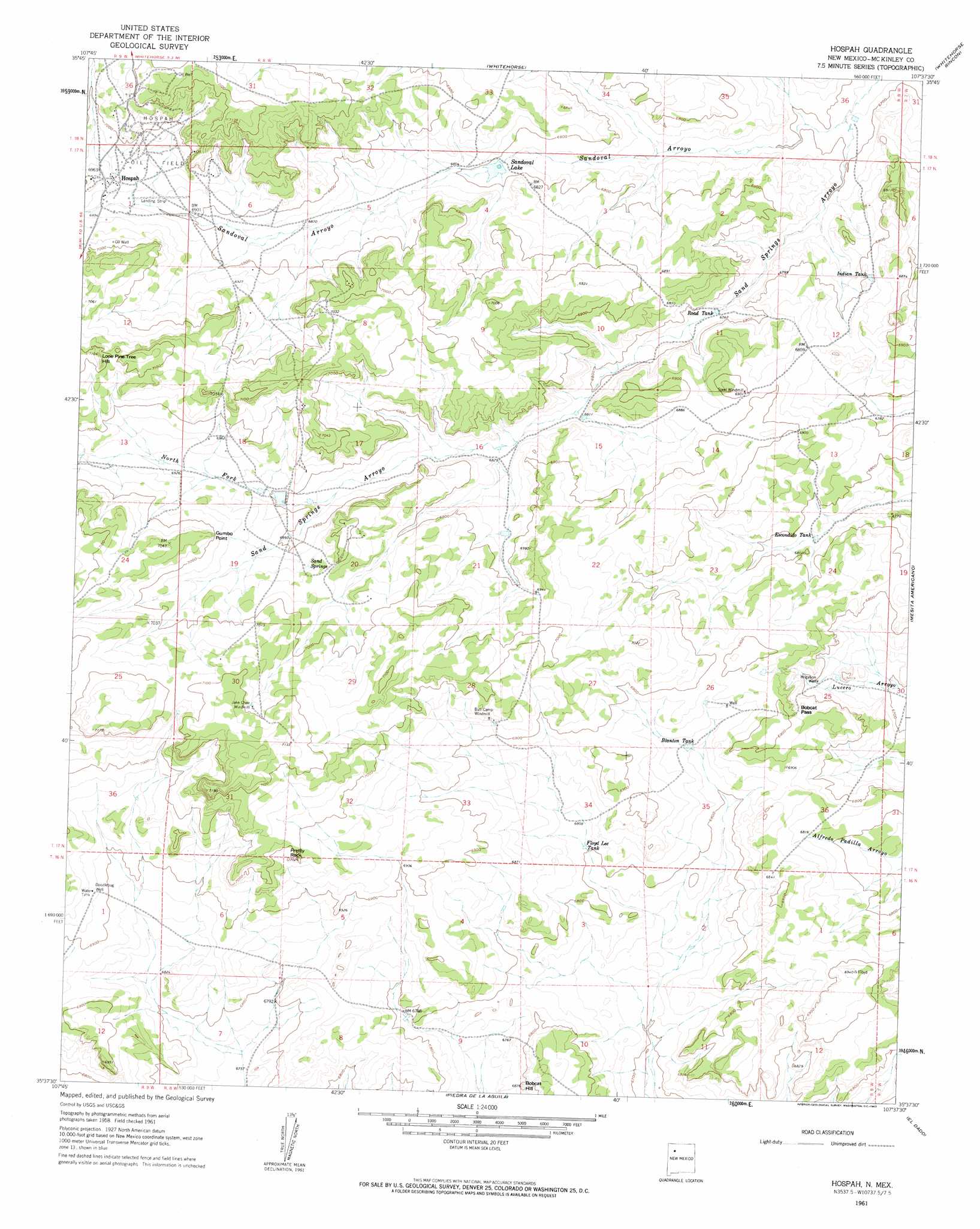
USGS Topo Quad 35107f6 - 1:24,000 scale
| Topo Map Name: | Hospah |
| USGS Topo Quad ID: | 35107f6 |
| Print Size: | ca. 21 1/4" wide x 27" high |
| Southeast Coordinates: | 35.625° N latitude / 107.625° W longitude |
| Map Center Coordinates: | 35.6875° N latitude / 107.6875° W longitude |
| U.S. State: | NM |
| Filename: | o35107f6.jpg |
| Download Map JPG Image: | Hospah topo map 1:24,000 scale |
| Map Type: | Topographic |
| Topo Series: | 7.5´ |
| Map Scale: | 1:24,000 |
| Source of Map Images: | United States Geological Survey (USGS) |
| Alternate Map Versions: |
Hospah NM 1961, updated 1963 Download PDF Buy paper map Hospah NM 1961, updated 1963 Download PDF Buy paper map Hospah NM 2010 Download PDF Buy paper map Hospah NM 2013 Download PDF Buy paper map Hospah NM 2017 Download PDF Buy paper map |
1:24,000 Topo Quads surrounding Hospah
Seven Lakes Nw |
Seven Lakes Ne |
Pueblo Pintado |
Pueblo Alto Trading Post |
Star Lake |
Seven Lakes |
Seven Lakes Se |
Whitehorse |
Whitehorse Rincon |
Rincon Marquez |
Laguna Castillo |
Orphan Annie Rock |
Hospah |
Mesita Americana |
Mesita Del Gavilan |
Borrego Pass |
Mesa De Los Toros |
Piedra De La Aguila |
El Dado |
Mesa Cortada |
Goat Mountain |
Ambrosia Lake |
San Lucas Dam |
Cerro Alesna |
El Dado Mesa |
> Back to 35107e1 at 1:100,000 scale
> Back to 35106a1 at 1:250,000 scale
> Back to U.S. Topo Maps home
Hospah topo map: Gazetteer
Hospah: Cliffs
Gumbo Point elevation 2134m 7001′Hospah: Gaps
Bobcat Pass elevation 2093m 6866′Hospah: Oilfields
Hospah Oil Field elevation 2130m 6988′Hospah: Populated Places
Hospah elevation 2121m 6958′Hospah: Reservoirs
Blanton Tank elevation 2080m 6824′Escondido Tank elevation 2066m 6778′
Floyd Lee Tank elevation 2074m 6804′
Indian Tank elevation 2076m 6811′
Road Tank elevation 2064m 6771′
Sandoval Lake elevation 2070m 6791′
Hospah: Springs
Sand Springs elevation 2120m 6955′Hospah: Streams
North Fork Sand Springs Arroyo elevation 2095m 6873′Sandoval Arroyo elevation 2037m 6683′
Hospah: Summits
Bobcat Hill elevation 2076m 6811′Lone Pine Tree Hill elevation 2178m 7145′
Pretty Rock elevation 2133m 6998′
Hospah: Wells
15R-321 Water Well elevation 2136m 7007′15R-321A Water Well elevation 2136m 7007′
15R-321B Water Well elevation 2136m 7007′
Doodlebug Well elevation 2113m 6932′
Hospah digital topo map on disk
Buy this Hospah topo map showing relief, roads, GPS coordinates and other geographical features, as a high-resolution digital map file on DVD: