Seven Lakes Topo Map New Mexico
To zoom in, hover over the map of Seven Lakes
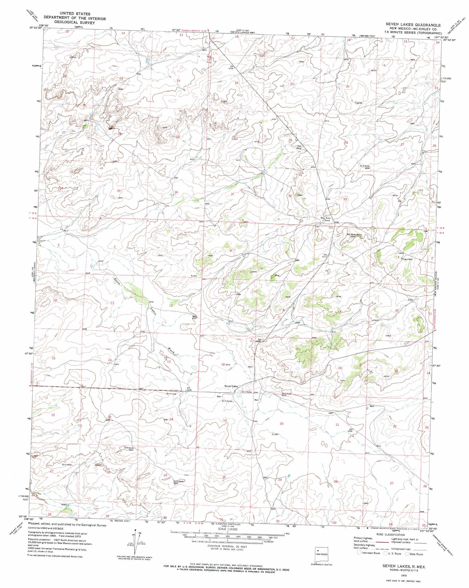
USGS Topo Quad 35107g8 - 1:24,000 scale
| Topo Map Name: | Seven Lakes |
| USGS Topo Quad ID: | 35107g8 |
| Print Size: | ca. 21 1/4" wide x 27" high |
| Southeast Coordinates: | 35.75° N latitude / 107.875° W longitude |
| Map Center Coordinates: | 35.8125° N latitude / 107.9375° W longitude |
| U.S. State: | NM |
| Filename: | o35107g8.jpg |
| Download Map JPG Image: | Seven Lakes topo map 1:24,000 scale |
| Map Type: | Topographic |
| Topo Series: | 7.5´ |
| Map Scale: | 1:24,000 |
| Source of Map Images: | United States Geological Survey (USGS) |
| Alternate Map Versions: |
Seven Lakes NM 1970, updated 1983 Download PDF Buy paper map Seven Lakes NM 2010 Download PDF Buy paper map Seven Lakes NM 2013 Download PDF Buy paper map Seven Lakes NM 2017 Download PDF Buy paper map |
1:24,000 Topo Quads surrounding Seven Lakes
La Vida Mission |
Kin Klizhin Ruins |
Pueblo Bonito |
Sargent Ranch |
Fire Rock Well |
Milk Lake |
Nose Rock |
Seven Lakes Nw |
Seven Lakes Ne |
Pueblo Pintado |
Antelope Lookout Mesa |
Becenti Lake |
Seven Lakes |
Seven Lakes Se |
Whitehorse |
Crownpoint |
Heart Rock |
Laguna Castillo |
Orphan Annie Rock |
Hospah |
Hosta Butte |
Casamero Lake |
Borrego Pass |
Mesa De Los Toros |
Piedra De La Aguila |
> Back to 35107e1 at 1:100,000 scale
> Back to 35106a1 at 1:250,000 scale
> Back to U.S. Topo Maps home
Seven Lakes topo map: Gazetteer
Seven Lakes: Populated Places
Seven Lakes elevation 1994m 6541′Seven Lakes: Wells
Artesian 1 Water Well elevation 1999m 6558′Artesian 3 Water Well elevation 1998m 6555′
Ferris 6 Water Well elevation 1995m 6545′
Hubbel Well elevation 2018m 6620′
M Parks 1 Water Well elevation 2021m 6630′
Pitt Number 5 Water Well elevation 1983m 6505′
Pitt Number 8 Water Well elevation 2024m 6640′
Ruby Water Well elevation 2061m 6761′
Ruby Wells elevation 2087m 6847′
Togie Well elevation 2091m 6860′
Seven Lakes digital topo map on disk
Buy this Seven Lakes topo map showing relief, roads, GPS coordinates and other geographical features, as a high-resolution digital map file on DVD: