Paxton Springs Topo Map New Mexico
To zoom in, hover over the map of Paxton Springs
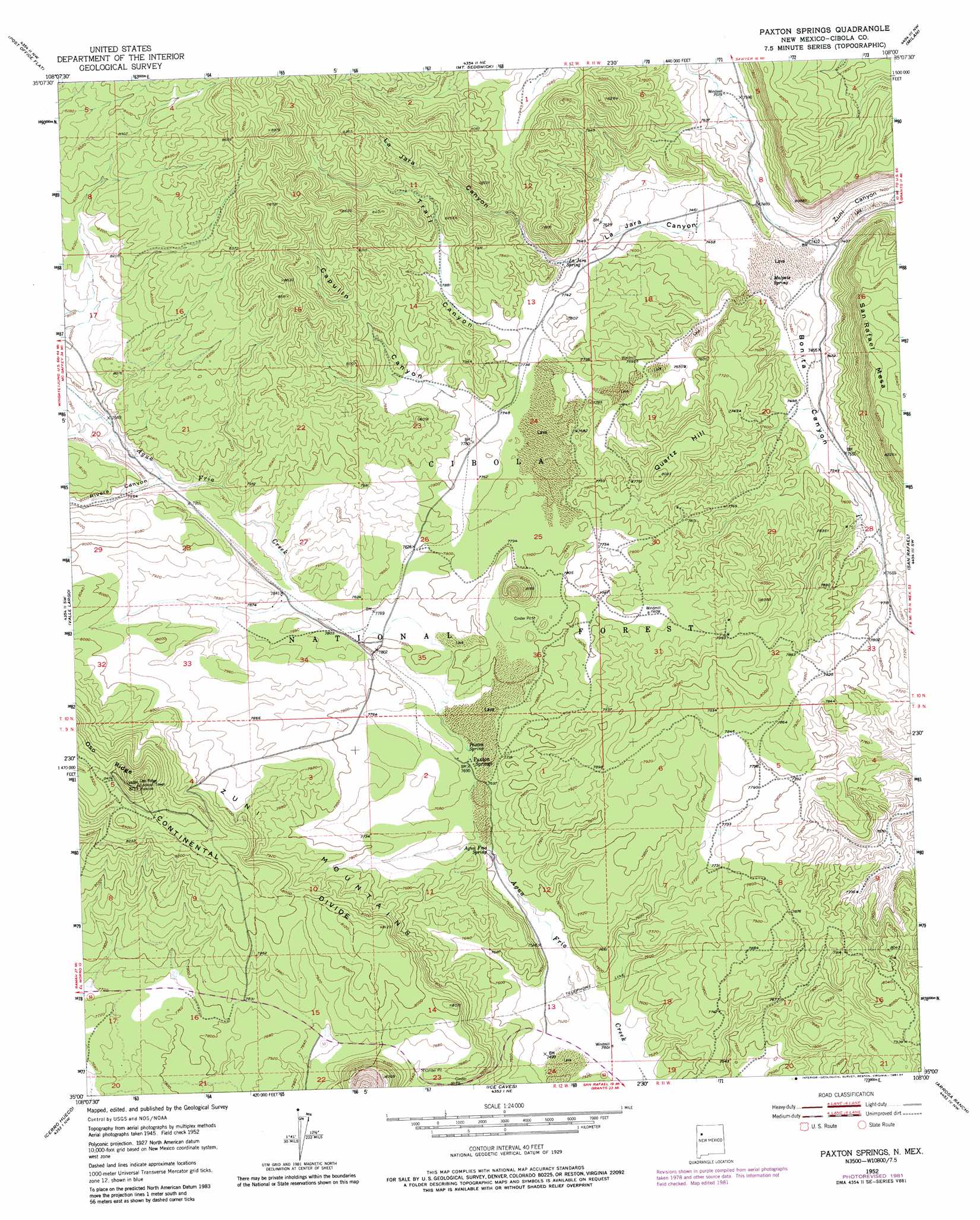
USGS Topo Quad 35108a1 - 1:24,000 scale
| Topo Map Name: | Paxton Springs |
| USGS Topo Quad ID: | 35108a1 |
| Print Size: | ca. 21 1/4" wide x 27" high |
| Southeast Coordinates: | 35° N latitude / 108° W longitude |
| Map Center Coordinates: | 35.0625° N latitude / 108.0625° W longitude |
| U.S. State: | NM |
| Filename: | o35108a1.jpg |
| Download Map JPG Image: | Paxton Springs topo map 1:24,000 scale |
| Map Type: | Topographic |
| Topo Series: | 7.5´ |
| Map Scale: | 1:24,000 |
| Source of Map Images: | United States Geological Survey (USGS) |
| Alternate Map Versions: |
Paxton Springs NM 1952, updated 1954 Download PDF Buy paper map Paxton Springs NM 1952, updated 1954 Download PDF Buy paper map Paxton Springs NM 1952, updated 1958 Download PDF Buy paper map Paxton Springs NM 1952, updated 1971 Download PDF Buy paper map Paxton Springs NM 1952, updated 1971 Download PDF Buy paper map Paxton Springs NM 1952, updated 1977 Download PDF Buy paper map Paxton Springs NM 1952, updated 1981 Download PDF Buy paper map Paxton Springs NM 1952, updated 1984 Download PDF Buy paper map Paxton Springs NM 1995, updated 1998 Download PDF Buy paper map Paxton Springs NM 2011 Download PDF Buy paper map Paxton Springs NM 2013 Download PDF Buy paper map |
| FStopo: | US Forest Service topo Paxton Springs is available: Download FStopo PDF Download FStopo TIF |
1:24,000 Topo Quads surrounding Paxton Springs
Cottonwood Canyon |
Pine Canyon |
Prewitt |
Bluewater |
Dos Lomas |
Kettner Canyon |
Post Office Flat |
Mount Sedgwick |
Milan |
Grants |
El Morro |
Valle Largo |
Paxton Springs |
San Rafael |
Grants Se |
Goat Hill |
Cerro Hueco |
Ice Caves |
Arrosa Ranch |
Los Pilares |
Cerro Alto |
Cerro Brilliante |
Ice Caves Se |
North Pasture |
Laguna Honda |
> Back to 35108a1 at 1:100,000 scale
> Back to 35108a1 at 1:250,000 scale
> Back to U.S. Topo Maps home
Paxton Springs topo map: Gazetteer
Paxton Springs: Airports
University of New Mexico Hospital Heliport elevation 2447m 8028′Paxton Springs: Mines
Betts Deposit elevation 2312m 7585′Bonita Mine elevation 2364m 7755′
Breece Deposit elevation 2432m 7979′
Holy Terror Prospect elevation 2387m 7831′
Juniper Deposit elevation 2399m 7870′
Malpais - Zuni Group Mine elevation 2399m 7870′
Stella Mae Prospect elevation 2358m 7736′
Zorro Deposit elevation 2335m 7660′
Zuni Number 1 Prospect elevation 2414m 7919′
Paxton Springs: Parks
Old Fort Wingate-Zuni Wagon Road Historic Site elevation 2322m 7618′Paxton Springs: Populated Places
Paxton Springs elevation 2352m 7716′Paxton Springs: Post Offices
Paxton Springs Post Office (historical) elevation 2429m 7969′Paxton Springs: Springs
Agua Fria Spring elevation 2322m 7618′La Jara Spring elevation 2333m 7654′
Malpais Spring elevation 2265m 7431′
Paxton Spring elevation 2354m 7723′
Paxton Springs: Streams
Agua Fria Creek elevation 2289m 7509′Paxton Springs: Summits
Quartz Hill elevation 2444m 8018′San Rafael Mesa elevation 2501m 8205′
Paxton Springs: Valleys
Capulin Canyon elevation 2363m 7752′La Jara Canyon elevation 2263m 7424′
Rivera Canyon elevation 2407m 7896′
Trail Canyon elevation 2373m 7785′
Winslow Canyon elevation 2380m 7808′
Paxton Springs: Wells
Aqua Fria Water Well elevation 2291m 7516′Lava Water Well elevation 2383m 7818′
Quartz Hill Water Well elevation 2317m 7601′
Paxton Springs digital topo map on disk
Buy this Paxton Springs topo map showing relief, roads, GPS coordinates and other geographical features, as a high-resolution digital map file on DVD: