El Morro Topo Map New Mexico
To zoom in, hover over the map of El Morro
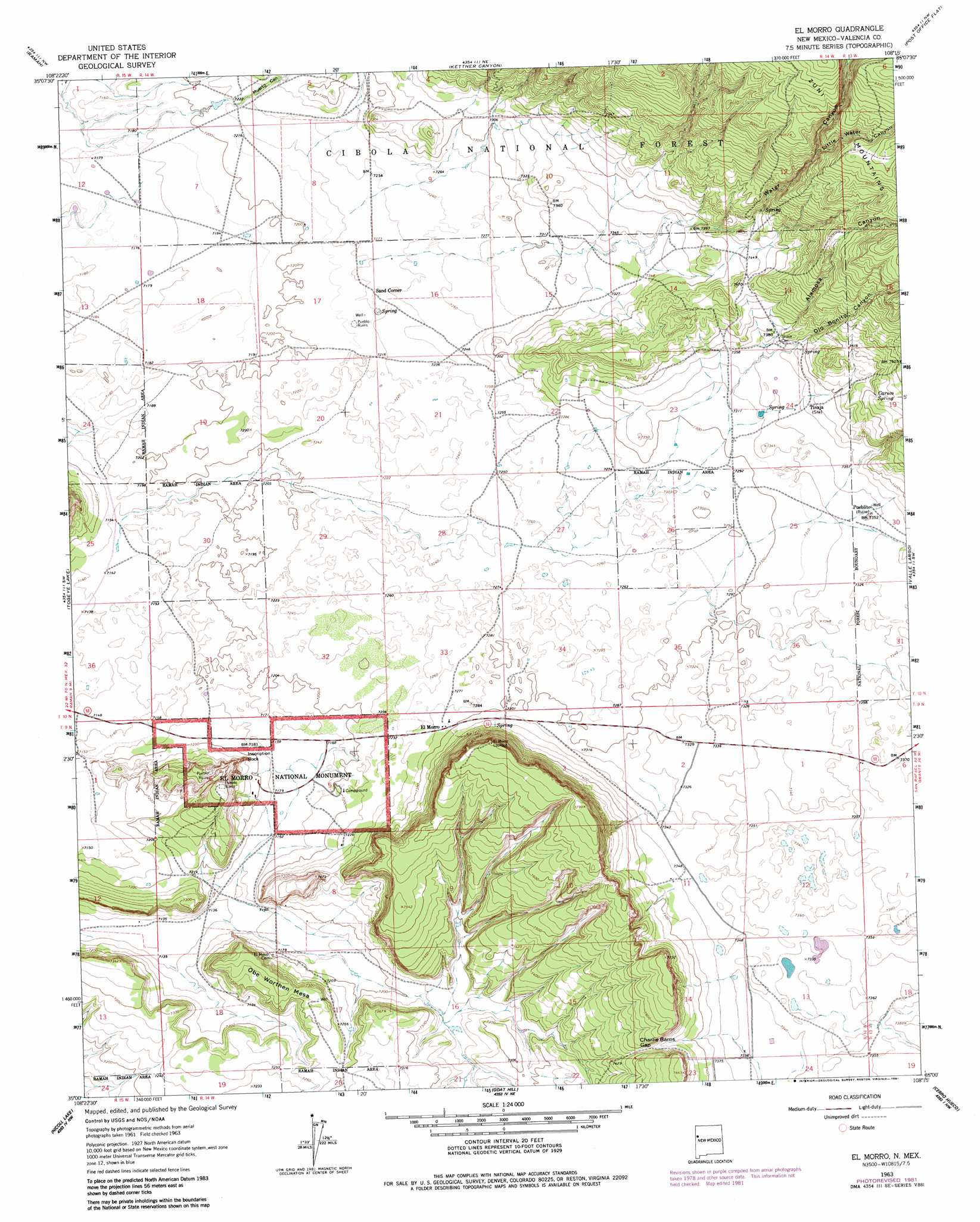
USGS Topo Quad 35108a3 - 1:24,000 scale
| Topo Map Name: | El Morro |
| USGS Topo Quad ID: | 35108a3 |
| Print Size: | ca. 21 1/4" wide x 27" high |
| Southeast Coordinates: | 35° N latitude / 108.25° W longitude |
| Map Center Coordinates: | 35.0625° N latitude / 108.3125° W longitude |
| U.S. State: | NM |
| Filename: | o35108a3.jpg |
| Download Map JPG Image: | El Morro topo map 1:24,000 scale |
| Map Type: | Topographic |
| Topo Series: | 7.5´ |
| Map Scale: | 1:24,000 |
| Source of Map Images: | United States Geological Survey (USGS) |
| Alternate Map Versions: |
El Morro NM 1963, updated 1965 Download PDF Buy paper map El Morro NM 1963, updated 1980 Download PDF Buy paper map El Morro NM 1963, updated 1981 Download PDF Buy paper map El Morro NM 1995, updated 1998 Download PDF Buy paper map El Morro NM 2011 Download PDF Buy paper map El Morro NM 2013 Download PDF Buy paper map |
| FStopo: | US Forest Service topo El Morro is available: Download FStopo PDF Download FStopo TIF |
1:24,000 Topo Quads surrounding El Morro
Upper Nutria |
Page |
Cottonwood Canyon |
Pine Canyon |
Prewitt |
Burned Timber Canyon |
Ramah |
Kettner Canyon |
Post Office Flat |
Mount Sedgwick |
Pescado |
Togeye Lake |
El Morro |
Valle Largo |
Paxton Springs |
Shoemaker Canyon |
Nicoll Lake |
Goat Hill |
Cerro Hueco |
Ice Caves |
Shoemaker Canyon Se |
Red Lake Mission |
Cerro Alto |
Cerro Brilliante |
Ice Caves Se |
> Back to 35108a1 at 1:100,000 scale
> Back to 35108a1 at 1:250,000 scale
> Back to U.S. Topo Maps home
El Morro topo map: Gazetteer
El Morro: Arches
Woodpecker Arch elevation 2233m 7326′El Morro: Gaps
Charlie Barns Gap elevation 2280m 7480′El Morro: Parks
El Morro National Monument elevation 2257m 7404′El Morro National Monument Inscription Rock Historical Marker elevation 2224m 7296′
Lava Beds Historical Marker elevation 2257m 7404′
Pueblo Revolt Tricentennial Historical Marker elevation 2257m 7404′
El Morro: Populated Places
El Morro elevation 2199m 7214′El Morro elevation 2224m 7296′
Sand Corner elevation 2205m 7234′
Tinaja elevation 2247m 7372′
El Morro: Post Offices
El Morro Post Office (historical) elevation 2224m 7296′El Morro: Springs
Caruco Spring elevation 2294m 7526′El Morro: Summits
Obe Worthen Mesa elevation 2247m 7372′El Morro: Valleys
Alamosa Canyon elevation 2238m 7342′Lily Canyon elevation 2240m 7349′
Little Water Canyon elevation 2373m 7785′
Muerto Canyon elevation 2202m 7224′
Ojo Bonito Canyon elevation 2234m 7329′
Water Canyon elevation 2250m 7381′
El Morro: Wells
Davis Brothers Water Well elevation 2191m 7188′El Morro Water Well elevation 2183m 7162′
El Morro digital topo map on disk
Buy this El Morro topo map showing relief, roads, GPS coordinates and other geographical features, as a high-resolution digital map file on DVD: