Kettner Canyon Topo Map New Mexico
To zoom in, hover over the map of Kettner Canyon
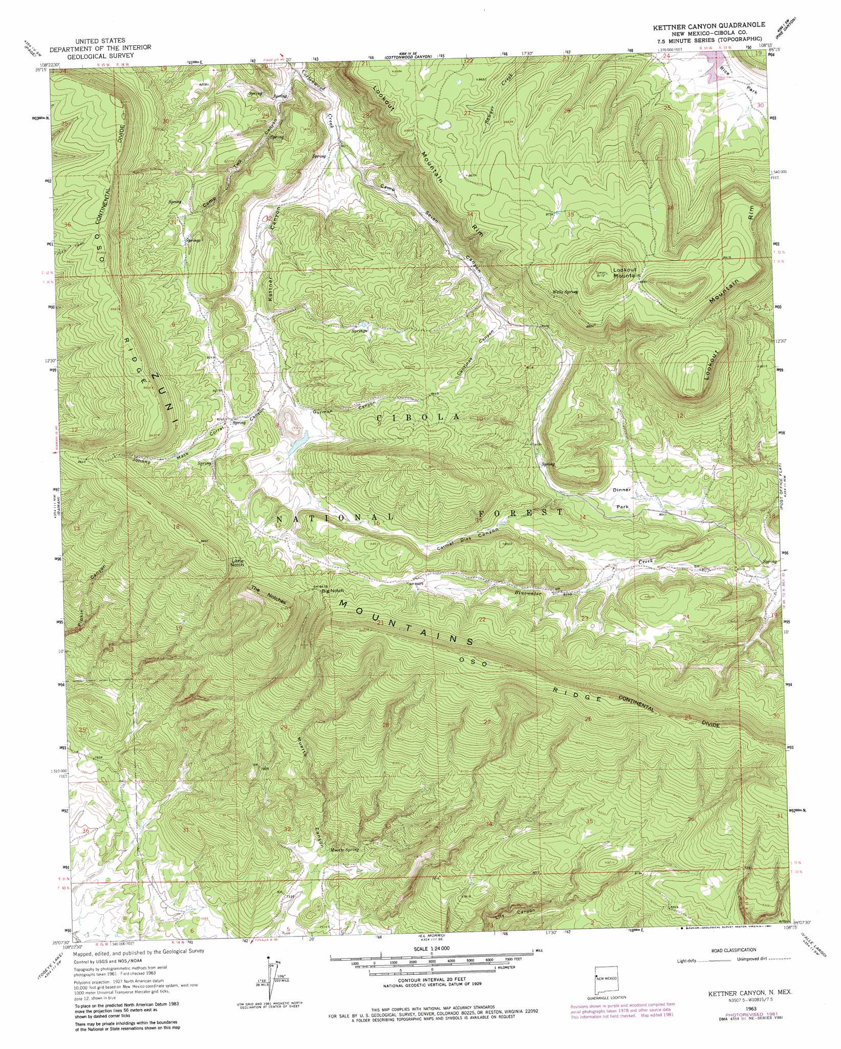
USGS Topo Quad 35108b3 - 1:24,000 scale
| Topo Map Name: | Kettner Canyon |
| USGS Topo Quad ID: | 35108b3 |
| Print Size: | ca. 21 1/4" wide x 27" high |
| Southeast Coordinates: | 35.125° N latitude / 108.25° W longitude |
| Map Center Coordinates: | 35.1875° N latitude / 108.3125° W longitude |
| U.S. State: | NM |
| Filename: | o35108b3.jpg |
| Download Map JPG Image: | Kettner Canyon topo map 1:24,000 scale |
| Map Type: | Topographic |
| Topo Series: | 7.5´ |
| Map Scale: | 1:24,000 |
| Source of Map Images: | United States Geological Survey (USGS) |
| Alternate Map Versions: |
Kettner Canyon NM 1963, updated 1965 Download PDF Buy paper map Kettner Canyon NM 1963, updated 1981 Download PDF Buy paper map Kettner Canyon NM 1995, updated 1997 Download PDF Buy paper map Kettner Canyon NM 2011 Download PDF Buy paper map Kettner Canyon NM 2013 Download PDF Buy paper map |
| FStopo: | US Forest Service topo Kettner Canyon is available: Download FStopo PDF Download FStopo TIF |
1:24,000 Topo Quads surrounding Kettner Canyon
Fort Wingate |
Ciniza |
Continental Divide |
Thoreau |
Thoreau Ne |
Upper Nutria |
Page |
Cottonwood Canyon |
Pine Canyon |
Prewitt |
Burned Timber Canyon |
Ramah |
Kettner Canyon |
Post Office Flat |
Mount Sedgwick |
Pescado |
Togeye Lake |
El Morro |
Valle Largo |
Paxton Springs |
Shoemaker Canyon |
Nicoll Lake |
Goat Hill |
Cerro Hueco |
Ice Caves |
> Back to 35108a1 at 1:100,000 scale
> Back to 35108a1 at 1:250,000 scale
> Back to U.S. Topo Maps home
Kettner Canyon topo map: Gazetteer
Kettner Canyon: Cliffs
Lookout Mountain Rim elevation 2636m 8648′Kettner Canyon: Flats
Dinner Park elevation 2461m 8074′Rice Park elevation 2509m 8231′
Kettner Canyon: Gaps
Big Notch elevation 2582m 8471′Little Notch elevation 2586m 8484′
The Notches elevation 2580m 8464′
Kettner Canyon: Lakes
Black Lake elevation 2647m 8684′Kettner Canyon: Ranges
Zuñi Mountains elevation 2681m 8795′Kettner Canyon: Reservoirs
Lookout Mountain Stock Tank elevation 2663m 8736′Kettner Canyon: Ridges
Oso Ridge elevation 2648m 8687′Kettner Canyon: Springs
Camp Two Spring elevation 2496m 8188′Muerto Spring elevation 2245m 7365′
Wells Spring elevation 2670m 8759′
Kettner Canyon: Summits
Lookout Mountain elevation 2777m 9110′Kettner Canyon: Valleys
Camp Seven Canyon elevation 2440m 8005′Camp Two Canyon elevation 2424m 7952′
Cantinas Canyon elevation 2530m 8300′
Carmel Dias Canyon elevation 2446m 8024′
Gurman Canyon elevation 2494m 8182′
Johnny Mack Corral Canyon elevation 2498m 8195′
Kettner Canyon elevation 2438m 7998′
Kettner Canyon: Wells
Muerto Well elevation 2246m 7368′Kettner Canyon digital topo map on disk
Buy this Kettner Canyon topo map showing relief, roads, GPS coordinates and other geographical features, as a high-resolution digital map file on DVD: